Details: Golzern - Hohenweg Maderanertal 
Distance: 5.0 - 9.8 miles (loop)
Bernese Oberland, near Altdorf in The Bernese Oberland
Hike Facts
- Distance: 5.0 - 9.8 miles (loop)
- Elevation: 4,577-ft. - 6,667-ft.
- Elevation Gain: 2,099-ft.
- Difficulty: moderate-strenuous
- Trail Highlights: See Trail Intro
- Basecamp(s): Altdorf
- Region: The Bernese Oberland
This is another of Switzerland's wonderful high routes with almost nonstop views. The trail loops around the Maderanertal, a pristine valley surrounds by soaring mountains, visiting the Windgallen Hut along the way. Waterfalls, wildflowers and small hamlets add interest to the hike.
Golzern to Windgallen Hut
Distance from Trailhead: 2.5 miles (one way)
Ending/Highest Elevation: 6,667-ft.
Elevation Gain: 2,099-ft.
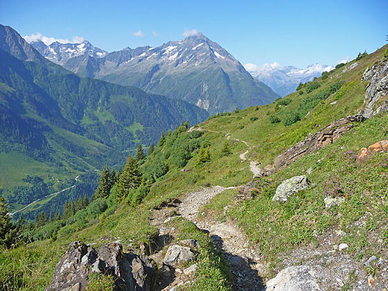
Upon arriving at the village of Bristen take the cable car to Golzern. (See trailhead directions below.) Take a few minutes outside the cable car station at Golzern to view Bristen (10,082-ft.), towering above the head of the valley to the southwest. From the trail signpost near the station start walking east on the broad track toward the Golzerensee and Windgallen Hut. The path passes some house as it travels through meadows and scatter trees on easy grades. At the next sign post you will see your trail listed as Trail 590 - the Hohenweg Maderanertal (hohenweg: high route).
At 0.7 miles the trail passes through the village of Seewen and reaches a junction. Straight ahead is a path leading to the Golzerensee, a pretty little lake. We bear left on the Hohenweg 590 toward Windgallen Hut.
The trail now climbs on steep grades through meadows and clusters of trees. The Oberalpstock (10,915-ft.), towering about the south side of the valley, forms a nice backdrop for the Golzerensee, nestled in a tree lined bowl below the trail.
At 1.3 miles, bear left at a junction to stay on the trail to Windgallen Hut. The trail climbs a switchback and then continues ascending northeast toward the hut. The Witenalpstock, Oberalpstock and Grosse Dussi (10,682-ft.) dominate the view across the valley.
The path soon climbs above the timberline, traveling through rocky meadows scattered with rock outcroppings. Ahead views open to the Gross Ruchen (10,292-ft.) and Chli Ruchen soaring above the trail.
Reach a junction at 2.2 miles and bear left on the Hohenweg 590 toward Windgallen Hut. The trail straight ahead, leading to Ofeli and Trift, bypasses the hut but continues along the high route toward the head of the valley. I call this trail the Ofeli Shortcut. I recommend continuing to the hut.
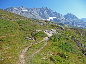
The trail now climbs steeply through rocky meadows, crossing a stream along the way, to reach the hut at 2.5 miles. The hut is set atop a bench amid alpine meadows with breathtaking views of the surrounding peaks. Gross Windgallen (10,456-ft.) and Gross Ruchen punctuate the ridge above the hut to the north. The Witenalpstock and Oberalpstock fill the skyline across the valley to the south while the Tschingelstock, adorned with the Tschingelfirn Glacier, rises to the southwest. At the head of the Maderanertal, to the east, Chli Ruchen and Gross Dussi frame the snout of the Hufifirn Glacier.
The hut is a good turnaround point for parties looking for a shorter hike (5.0 miles round-trip).
Completing the Loop
Distance from Trailhead: 9.8 miles (loop)
Ending/Highest Elevation: 2,730-ft.
Elevation Gain: -3,937-ft.
After you are done taking in the views around Windgallen Hut, descend from the hut toward Ofeli. The path drops steeply for 0.25 miles and then moderates.
At 2.8 miles the trail passes through the hamlet of Stafel and soon reaches the junction with the Ofeli Shortcut trail at 3.0 miles. Here we bear left on the Hohenweg 590 toward Tritt. The path now descends on moderate grades through beautiful meadows, crossing several streams along the way. Soon the meadows give way to heather, shrubs and stunted trees. Across the valley Gross Dussi dominates the view while the Ruchen massif soars overhead.
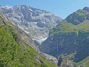
At 3.5 miles ignore a trail branching left toward Alp Gnof and Tritt. We stay on the main trail toward Tritt and Hufihutte. Reach Ofeli and a junction at 3.6 miles. Here a trail branches right toward Balmenschachen. This is a good shortcut if the weather is taking a turn for the worse. Otherwise continue straight ahead toward Tritt. Across the valley views open to a waterfall spilling from a hanging valley.
The trail crosses a series of metal walkways below a waterfall at 3.8 miles. A small landslide has made a mess of the trail, requiring the detour. A short distance beyond the trail passes another pretty waterfall cascading down a rugged cliff.
Reach Tritt at 4.2 miles. Beyond the alp the trail starts descending on steep switchbacks to the valley floor. Along the way enjoy fine views of Gross Dussi and the snout of the Hufifirn Glacier. Waterfalls spill down the steep cliffs nearby.
At 4.5 miles an unmarked trail branches left. We continue on the main trail, which now turns to the southwest toward Balmenegg and Bristen. Lovely views stretch down the length of the valley to Mount Bristen. Waterfalls tumble down steep cliffs on both sides of the valley.
The switchbacks end as you reach Sassalp and a junction at 5.0 miles. Ignore trails branching left toward Hufihutte. Continue on Hohenweg 590 toward Bristen. The trail now drops on a diagonal down to the valley floor, descending on moderate to moderately-steep grades through meadows and clusters of trees. Along the way we pass several delightful waterfalls and enjoy views of Dussi and Mount Bristen.
Reach Balmenegg at 5.8 miles and a trail junction at 5.9 miles. Ignore the bike trail that heads left. Instead, stay on the Hohenweg 590 toward Bristen.
At 6.6 miles our trail descends to Balmenschachen, crosses the Charstelenbach River on a bridge and then passes through Alp Stossi. The Hohenweg 590 now travels along the valley floor, crossing the river two more times before ending at Bristen near the cable car station at 9.8 miles. From there it is a short walk back to the bus stop.
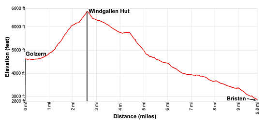
Elevation Profile
Driving Directions
From Altdorf to Golzern: From Altdorf take the #1 bus (Stand B) at Telldenkmal, the main square in the center of town, in the direction of Goschenen. Get off at Amsteg Post and catch the bus to Golzern Talstation Seilbahn (valley station for the cable car) in Bristen. It’s a short walk from the bus stop to the cable car. Ride the cable car to Golzern. Check the schedule before setting out. Given the length of this hike it is best to catch an early bus. The two bus rides take about 43 minutes and the cable car takes 36 minutes.
Bus schedules are posted at the bus stops and are available online at the SBB website or the SBB app. When looking for buses use “Altdorf UR, Telldenkmal”, the UR in the name stands for the canton of Uri. The schedule and pricing for the cable car is found on the Luftseilbahn Golzern website.
Trail Resources
Trail Intro / Trail Photo Gallery / Trail Map
Basecamp(s) Information:
Altdorf
Region Information:
The Bernese Oberland
Other Hiking Regions in:
Switzerland