Details: Altdorf to Engelberg via Surenen Pass 
Distance: 8.9 - 13.0 miles (one way)
Bernese Oberland, near Altdorf in The Bernese Oberland
Hike Facts
- Distance: 8.9 - 13.0 miles (one way)
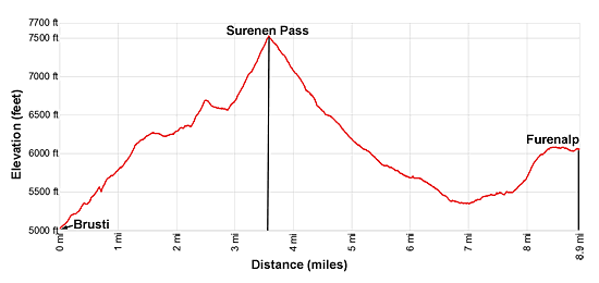
- Elevation: 5,003-ft. - 7,516-ft.
- Elevation Gain: 2,513-ft.
- Difficulty: strenuous
- Trail Highlights: See Trail Intro
- Basecamp(s): Altdorf / Engelberg
- Region: The Bernese Oberland
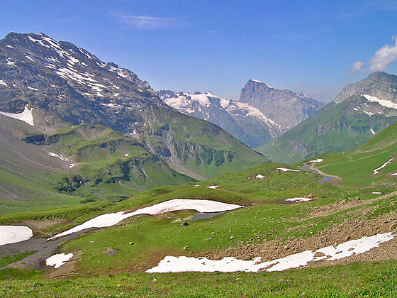
The Alpine Pass Route from Altdorf to Engelberg ascends through meadows framed by rugged peaks to Surenen Pass where Titlis and the Schloss and Spannort massifs dominate the view. The scenic descent to Engelberg features views of towering, jagged peaks adorn with waterfalls and a dramatic cirque.
To Surenen Pass

Distance from Trailhead: 3.6 miles (one way)
Ending/Highest Elevation: 7,516-ft.
Elevation Gain: 2,513-ft.
Purist may want to hike all the way from Altdorf to Engelberg, a 17.2 mile hike with over 6,000-ft. of elevation gain. My advice is to take advantage of transportation at the beginning and end of the walk so that you have more time to savor the beautiful scenery the area has to offer.
Start the day by taking the bus from Altdorf to Attinghausen where a two-stage cable-car ascends to Brusti. This combination reduces the elevation gain by over 3,500-ft. and cuts the distance by 4.2 miles.
An alternative stopping point at Furenalp employs a cable car and bus to reach Engelberg, eliminating a long walk along roads. See the trailhead directions below for more information on transportation alternatives at the beginning and end of the hike.
Altdorf to Brusti
(Note: regularly scheduled buses travel from central Altdorf and the Altdorf train station to the Attinghausen-Brusti cable car. See the trailhead directions below.)
Walk south from the Altdorf train station along the road paralleling the train line. After 0.7 miles turn right on a road that goes under the railway and highway and then crosses a bridge over the Reuss River. Signs for the Via Alpina (Alpine Pass Route), Surenen Pass and Attinghausen mark the turn.
In Attinghausen, on the west side of the river, continue west/southwest on Burgstrasse (Burg Street) and then bear slightly right onto Kummetstrasse (Kummet Street). Soon you will see the bottom station for the two-stage Attinghausen-Brusti cable car on your left (south) at 1.2 miles.
To take the cable car, walk into the unmanned station and push the signal button on the wall. Wait until you hear the operator’s voice answer the call and then reply, “Bergfahrt, bitte.” Your party should then enter the cable car, close the door and then push the button inside the cable car to signal to the operator that he can start the cable car. (Payment for the cable car is collected by the operator at the middle station.)
For those walking to Brusti, locate the Via Alpina (Alpine Pass Route) signs outside the cable car station. The path initially ascends along the north side of the Chummetbach stream to the middle cable car station. Here the path crosses to the south side of the stream and briefly climbs along roads before turning right and ascending very steeply through pastures and viewless forest to the top station for the cable car at 4.2 miles. Signs along the way for Brusti and Surenen Pass will keep you on track.
Brusti to Surenen Pass
(Mileage for this section of the description assumes you take the cable car to Brusti. Add 4.2 miles to the trail distances if walking from Altdorf.)
Outside the top station for the cable car at Brusti find a signed track heading west toward Surenenpass and Engelberg. At the first intersection turn left on the broad track toward Surenen Pass.
The trail ascends past houses and then climbs an undulating path along a ridge, traveling through stunted trees, bushes and intermittent meadows. Hand rails offer a level of security along sections of the path with steep drop-offs. Along the way the trail pass through Chraienhoreli where a path branches right to the small alp at Chaserli. We continue toward Surenen Pass. After 0.8 miles the trees give way to low shrubs and meadows where views open east/northeast to Altdorf and the high peaks rimming the Schachental (Schachen Valley).
At 1.1 miles reach Grat where signs point right toward a small alp building and Seedorf. We bear left toward Surenen Pass on the Via Alpina (Alpine Pass Route) trail that climbs through beautiful, wildflower-filled meadows to the ridge separating the Waldnacht Valley to the south from the Gitschital to the north. The path now ascends along or near the ridge crest accompanied by fine views of the Gitschenhoreli, Brunnistock and Blackenstock towering above the head of the valley. Surenen Pass, the saddle to the left (south) of Blackenstock, is now in view. To the northeast you can see a small section of the Urnersee, an arm of the Vierwaldstattersee (Lake Lucerne). To the south a ridge punctuated by rugged peaks rims the Waldnacht Valley.
At 1.6 miles the grade briefly abates as the trail wanders along the ridge and then resumes its climb at 2.0 miles. Soon the grade steepens as the trail ascends to Angistock at 2.5 miles, located near the head of the ridge. Ahead Surenen Pass is now in view.
At Angistock a faint path branches right, crossing steep, scree covered slopes before rejoining the main trail below the pass. Periodic rockslides have made this trail a dicey proposition and warnings painted on nearby rocks indicate that the path is no longer recommended. Instead bear left on the main Via Alpina trail toward Langschnee and Surenen Pass. The trail descends into a bowl, passes the junction at Langschnee, crosses a snowfield that lasts well into the summer and then climbs steeply to the pass at 3.6 miles.
As you crest the pass snow-capped Titlis springs into view, soaring above the Schloss and Spannort massifs rimming the south side of the Surenen Valley. A few small tarns lie below the pass. The rugged crags of Blackenstock rise above the pass to the north. Behind you views stretch east down the Brusti side of the pass. On a nice day the grassy pass is a great place to take a break and enjoy the views.
To Engelberg

Distance from Trailhead: 13.0 miles (one way)
Ending/Highest Elevation: 3,287-ft.
Elevation Gain: -4,229-ft.
The trail on the west side of the pass descends through meadows on steep to moderately steep grades, passing Schutzhutte, an emergency shelter, and then a wooden cross, which seems to be a favorite resting place for a herd of cows. Accompanying the descent are terrific views of Titlis and the wall of high peaks rimming the south side of the Surenen Valley.
Reach Blankenalp at 5.5 miles. This scenic spot, standing at the foot of a massive cirque formed by the Schuflen, Wissigstock, Schlossstock and Blackenstock, includes a restaurant and dormitory accommodations. A short distance past the alp the trail passes a pretty white chapel on a hill and then crosses a bridge over the Stierenbach, the stream draining the valley.
The descent now continues on moderate grades to a second bridge over the Stierenbach and a junction at Stauber at 6.7 miles. Here the trail splits, with the Via Alpina branching left toward Engelberg. The trail to the right heads to Furenalp.
The scenic trail to Furenenalp, a high route gaining about 900-ft. in 2.2 miles, ends with a cable car descent to the Engelbergertal (Engelberger Valley) where you can either walk or take a bus back to Engelberg. The traditional route, which also includes good views, descends more gradually along the valley floor beside the river, losing over 2,300-ft in 6.5 miles to Engelberg.
Stauber to Engelberg
The traditional valley route to Engelberg descends down the valley along the north side of the river beneath the towering cliffs and jagged peaks of the Spannort massif. Waterfalls, fed by snowmelt and glaciers, cascade down the slopes. Pass a the cable car station at Stafeli at 7.4 miles and the bottom station for the Furenalp cable car at Herrenrutiboden at 10.3 miles. Here the trail joins a macadam road that leads to a popular restaurant near a waterfall at 10.6 miles. (You can catch the bus back to Engelberg at either Herrenrutiboden or the waterfall.)
Hikers wanting to walk the entire way can follow a combination of roads and paths, passing through Vorder Stalden and Holzkapelle to the center of Engelberg for a 17.2 mile hike, if you walked all the way from Altdorf, or a 13.0 mile hike, if you walked from Brusti. At all turns follow the signs toward Engelberg and not the blue Alpine Route signs you may see along the way.
Stauber to Furenalp
The trail to Furenalp ascends on easy to moderate grades up the wildflower-filled meadows beneath the Wissberg. Across the valley enjoy great views of Gross Spannort, Chli Spannort and the Grassengrat ridge. Glaciers adorn the upper slopes of the peaks. Waterfalls cascade down the steep slopes beneath the glaciers.
At 7.6 miles reach a junction at Usser Aebnet. Continue on the main trail to Furenalp. Behind you are terrific views of Blackenstock rising above Surenen Pass. Across the valley to the south the views of the Spannort massif continue to evolve as you head west. At 7.8 miles the grade steepens and soon starts climbing switchbacks. The ascent ends at 8.4 miles. The trail now traverses a grassy bench awash in wildflowers along the south facing slopes of the Wissberg, reaching the cable car station at Furenalp at 8.9 miles.
Take the cable car down to the valley station at Herrenrutiboden. Here you can catch a bus to Engelberg or walk to Engelberg following the directions above.
Elevation Profile
Driving Directions
From Altdorf to Attinghausen/Brusti: From the Altdorf train station catch a #2 bus at Stand B to the Attinghausen Seilbahn. If starting from Telldenkmal, the main square in the center of Altdorf, take the #2 bus from Stand C to the Attinghausen Seilbahn. There are a variety of other bus combinations that work. Bus schedules are posted at the bus stops and are available online at the SBB website or on the SBB app. When looking for buses use “Altdorf UR, Telldenkmal” or “Altdorf UR, Bahnhof”, the UR in the name stands for the canton of Uri.
The schedule for the two-stage cable car from Attinghausen to Brusti is available at the Attinghausen Tourism site. The lift typically runs from 7am to 7pm in the summer with a break for lunch. Check the website for the current schedule.
From Furenalp to Engelberg: Take the Furenalp Luftseilbahn to the valley station at Herrenrutiboden where shuttle buses run to Engelberg. The lift typically runs from 8am to 6pm in the summer. You can also walk eight minutes west from the valley station to the bus stop at the Wasserfall (Waterfall) and catch the #10 Bus to Engelberg. Bus schedules are posted at the bus stops and are available online at the SBB website or on the SBB app.
Trail Resources
Trail Intro / Trail Photo Gallery / Trail Map
Basecamp(s) Information:
Altdorf / Engelberg
Region Information:
The Bernese Oberland
Other Hiking Regions in:
Switzerland