Details: Griesalp to Kandersteg via Hohturli 
Distance: 9.1 miles (one way)
near Griesalp in The Bernese Oberland
Hike Facts
- Distance: 9.1 miles (one way)
- Elevation: 4,630-ft. - 9,350-ft.
- Elevation Gain: 4,720-ft.
- Difficulty: strenuous-difficult
- Trail Highlights: See Trail Intro
- Basecamp(s): Griesalp / Kandersteg
- Region: The Bernese Oberland
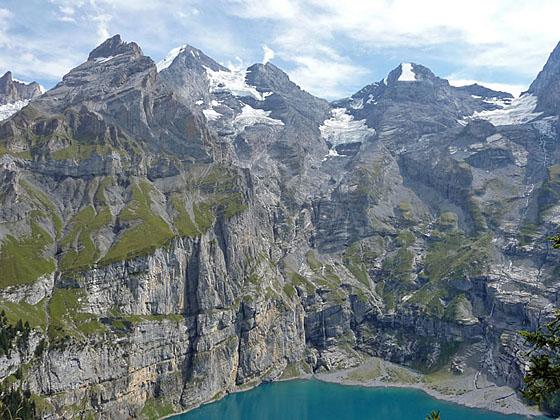
The challenging hike over Hohturli Pass features captivating vistas of the high peaks towering above the Kiental and Kandertal valleys, front row seats to the dazzling Bluemlisalp Glacier and stunning views of the rugged cirque soaring above the Oeschinensee, one of the most beautiful lakes in Switzerland.
Griesalp to Hohturli and Bluemlisalp Hut
Distance from Trailhead: 4.1 miles (one way)
Ending/Highest Elevation: 9,350-ft.
Elevation Gain: 4,720-ft.
Find the trail signs across from the Berghaus Griesalp (4,620-ft.), aka the Griesalp Hotelzentrum. Walk south on the trail toward Bundalp (1-hr 15-min), Hohturli/Bluemlisalphutte (4-hr 15-min) and Kandersteg (7-hr 30-min). The trail climbs a hill to a road and then turns left (southeast) on the road toward Hohturli Pass.
At 0.3 miles take the trail branching left off the road toward Hohturli. The trail now enters the forest and crosses a low rise before descending gently through a pasture, passing a trail junction and farm house along the way. At all junctions continue walking toward Hohturli.
Beyond the house the trail crosses a stream at 0.9 miles and then climbs up a forested hillside on a steep rocky path. Soon the forest gives way to pasture as the trail reaches a junction at Untere Bundalp (5,545-ft.). Cross the alp road and continue climbing moderate to steep grades up rocky pastures, shortcutting long switchbacks on the road.
At 1.6 miles the trail crosses the road again and then climbs to the Berghaus-Restaurant Bundalp at Obere Bundalp at 1.7 miles. Here signs direct you along a gravel alp road between two buildings. At the south edge of the alp follow the road as it ascends south through pastures on moderate grades, crossing two streams along the way.
Turn right (south) toward Hohturli on the trail branching off the road at 1.9 miles. The continuation of the route along the road leads to Gspaltenhornhutte and the Sefinenfurgge. Follow the trail as it climbs steeply up undulating, rocky meadows toward the rugged ridge rising to the south. Some sections of the trail are braided and eroded.
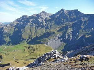
At 2.5 miles pass the junction with a trail branching left toward Sefinenfurgge and Gspaltenhornhutte. Continue straight ahead (south) toward Hohturli. The trail now climbs very steep, tight switchbacks along the left side of a gully. Take occasion breaks from the climb to enjoy views of Zahm Andrist, Wild Andrist and the Hundshorn rising across the valley to the north.
At 3.0 miles the meadows give way to scree covered slopes as the trail continues its relentless climb toward a minor ridge extending northeast from the pass. Soon the trail curves to the southeast and climbs through talus and boulders to the ridge crest at 3.3 miles.
The trail quickly crosses the ridge and curves to the southwest, ascending along a narrow bench on the east side of the ridge. Looking up toward the pass you can’t help but to wonder how a trail was constructed to scale the extremely steep scree-covered gully running along the east side of the ridge. This is definitely not a trail for anyone with a fear of heights.
Follow the very steep trail, carved into the scree-covered slopes, along the right side of the gully beneath the ridge’s sheer rock walls. At 3.5 miles the trail reaches the first of a series of wood steps, some with fix ropes, to facilitate the exceedingly steep climb to the pass. Chains, secured to the rock face along the ridge provide safeguard the final steep haul to the pass.
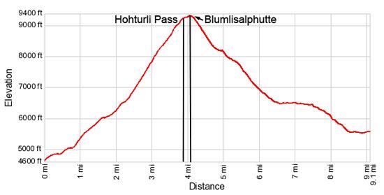
Reach Hohturli Pass (9,114-ft.) at 3.8 miles and a 4,484-ft. elevation gain. From the pass enjoy great views extending southwest down the length of the Oeschinen Valley to the peaks towering over the west side of Kandersteg. Sefinenfurgge Pass, the notch on the saddle between the Hundshorn and Butlasse, is visible to the east. To the north fine views extend down the Kiental Valley and beyond with Lake Thun in the distance. Nearer at hand are wonderful views of the dazzling glaciers spilling down the flanks of the Bluemlisalp massif to the south.
For even better views of the glacier, turn southeast and climb steep switchbacks leading to Bluemlisalphutte (9,297-ft.). Reach the hut, which offers dormitory accommodations and meals, at 4.0 miles. A use trail, skirting the southwest side of the hut, crosses a large boulder field and then scree-covered slopes on its way to great viewpoints (9,350-ft.) overlooking the Bluemlisalp Glacier at 4.1 miles. Here you have a bird’s-eye view of the motionless rivers of ice flowing around the Utem Stock, a horn protruding from the flanks of the Bluemlisalp massif.
From Hohturli to Kandersteg (Complete Hike)

Distance from Trailhead: 9.1 miles (one way)
Ending/Highest Elevation: 5,530-ft.
Elevation Gain: -3,820-ft.
When you are ready to continue to Kandersteg retrace your steps to the pass. From the pass a very steep trails descends west down scree-covered slopes toward Ober Bergli (1-hr 30-min), Oeschinensee (2-hr 14-min) and Kandersteg (3-hr 15-min), losing over 1,000-ft in 0.75 miles. Wood steps and plank bridges facilitate the descent over eroded and extremely steep sections of the trail.
Soon the scree gives way to rocky meadows and the grade eases a bit as the trail curves left (southwest), descending on moderately-steep grades atop the remains of an old moraine wall. Switchbacks help ease the descent down rocky benches. To the south enjoy wonderful views of the tongues of the Bluemlisalp Glacier hanging from a high shelf. Unfortunately the receding glacial tongues are not quite a dramatic as they were 10-15 years ago.
At 5.4 miles the descent steepens as the trail travels along the knife-edge crest of the moraine. Soon the trail drops off the moraine wall, descends very steep switchbacks and then travels through rocky meadows to the pretty pastures above Ober Bergli at 6.4 miles.
Follow the trail as it makes a wide arc around the pastures, avoiding a field strewn with boulders from an old rock slide. The path then crosses a bridge over a stream and soon reaches a trail junction near the farm buildings at Ober Bergli (6,473-ft.) at 6.6 miles. Ober Bergli is located at the foot of a small hanging valley high above the northeast end of the Oeschinensee, in my opinion one of the most beautiful lakes in the Swiss Alps.
From Ober Bergli, there are two trails descending to the Oeschinensee gondola and Kandersteg. The shortest trail branches left (south/southwest) toward the Oeschinensee (45-min) and Kandersteg (1-hr 45-min). This route drops steeply down to Unter Bergli (5,797-ft.) and then descends along the north side of the Oeschinensee to Lager at the foot of the lake. Beyond Lager the trails ascends to the lift station where a gondola whisks hikers down to Kandersteg. Alternatively you can follow a trail from Lager dropping on very steep grades to Kandersteg (3,858-ft.).
A more scenic and slight longer trail contouring high above the north side of the lake branches right (northwest) to Heuber, Lager (1-hr) and Kandersteg (2-hr 10-min). This trail features stunning views of the dramatic cirque of rugged peaks towering above the lake’s turquoise waters. On a nice day this is the trail to take. If the weather is threatening or if it is foggy, drop down to the lake.
Assuming it is a nice day, turn right on the high trail. Before long the trail crosses back to the north side of the stream and starts contouring high above the northeast end of the lake. At 6.8 miles great views open to the Doldenhorn towering high above the Oeschinensee. Soon the Frundenhorn joins the scene. Glaciers tumble down the rugged slopes beneath the peaks. Waterfalls, fed by glacial melt water, cascade down the peak's sheer walls to the lake.
The narrow trail now winds through meadows, crosses rockslide and navigates rocky gullies along the valley’s steep, sinuous walls, high above the north side of the lake. Caution is required in a few spots with a little bit of exposure.
Turn around for great views that extend up the valley to the pass. The Bluemlisalp Glacier tumbles down the slopes between the Bluemlisalp-Rothorn, Ufem Stock and Wyssi Frau, rugged horns protruding from the flanks of the Bluemlisalp massif.
At 7.7 miles a grassy knoll atop a bench beckons hikers to stop and soak in the sublime views. You now have a great perspective of the amazing sheer walls ringing the Oeschinensee along with the rugged peaks forming the stunning glacial cirque surrounding the lake.
Beyond the knoll the trail descends on steep to moderately-steep grades through meadows and groves of evergreens, crossing a few talus covered slopes along the way. At 8.6 miles the trail reaches a junction with a gravel road. Turn right (west) to take the path toward the Oeschinensee Gondola to Kandersteg. Turn left (east) to walk down to Kandersteg.
I recommend taking the gondola down to Kandersteg. Walk west along the gravel road, following the signs directing you to the bergstation (top of the gondola). Reach the gondola’s bergstation (5,530-ft.) at 9.1 miles.
If you prefer to walk all the way to Kandersteg take the trail to the left (east/southeast), which descends to Kandersteg on a steep trail along the Oschibach -- a pleasant stream with nice views of the steep walls lining the south side of the valley. There is also a trail to Kandersteg that starts at the top of the gondola and drops down steep switchbacks beneath the gondola. The trail descending along the Oschibach is the better option.
Elevation Profile
Driving Directions
From Griesalp: Find the trail signs near the postbus stop adjacent to the Griesalp Hotelzentrum.
Reaching Griesalp by bus/train: Griesalp is located near the head of the Kiental, a side valley of the Kandertal. Travel on the Bern-Brig Lotschberg railway line to Reischenbach (from Brig or Bern take the Regio Express called "Lotschberger"). At the Reischenbach Bahnhof board the postbus (minibus) to Griesalp. The road to Griesalp travels up very tight hairpin curves on the steepest mountain postal route in Europe. A standard size bus is unable to make the journey. Schedules are available online at the SBB website or download the SBB app.
Trail Resources
Trail Intro / Trail Photo Gallery / Trail Map
Basecamp(s) Information:
Griesalp / Kandersteg
Region Information:
The Bernese Oberland
Other Hiking Regions in:
Switzerland