Details: Ammerten Pass and the Ammertenspitz 
Distance: 5.5 - 6.5 miles (round trip)
Bernese Oberland, near Kandersteg in The Bernese Oberland
Hike Facts
- Distance: 5.5 - 6.5 miles (round trip)
- Elevation: 6,437-ft. - 8,573-ft.
- Elevation Gain: 1,578-ft. - 2,138-ft.
- Difficulty: moderate-strenuous
- Trail Highlights: See Trail Intro
- Basecamp(s): Kandersteg
- Region: The Bernese Oberland
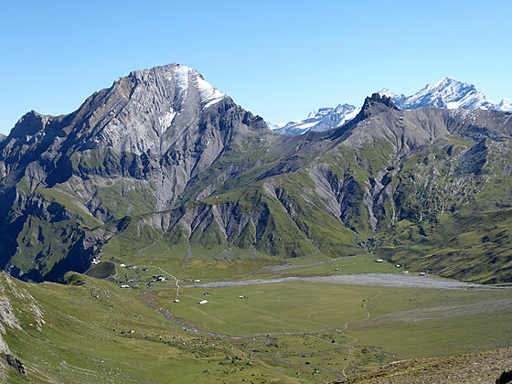
Ascend the beautiful Engstligenalp valley to scenic Ammerten Pass with great views of the peaks surrounding the valley and the mountains rising to the south. From the pass a steep trail leads to the Ammertenspitz summit with panoramic views encompassing the summits towering above Adelboden, Lenk and beyond.
Engstligenalp to Ammerten Pass
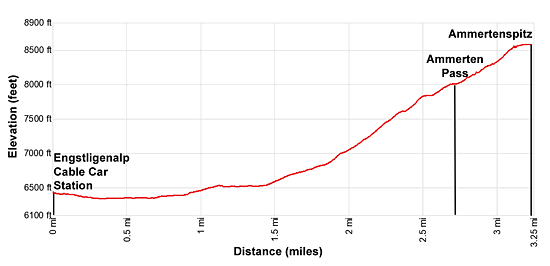
Distance from Trailhead: 5.5 miles (round trip)
Ending/Highest Elevation: 8,015-ft.
Elevation Gain: 1,578-ft.
From Unter dem Birg, ride the cable car to Engstligenalp. (See trailhead directions below.) Outside the station follow the broad track heading south toward Ammertenpass (Ammerten Pass) and Lenk. The trail curves to the right (southwest) as it descends to the valley floor and then crosses bridges over streams at 0.3-miles and 0.4-miles. At all junctions stay on the broad track toward Ammertenpass.
The easy walk up the valley enjoys lovely views of the Engstligenalp valley, a large emerald green bowl ringed by peaks and ridges. Ahead the Steghorn, Grossstrubel and Ammertenspitz tower above the head of the valley. A long ridge, punctuated by the Rotstock and Fitzer, defines the valley to the west while the Engstligengrat and Artelegrat ridges, linked by the Tschingellochtighorn, rim the valley to the east and north.
At 0.7 miles the path crosses a bridge over the Entschlige stream and then ascends to and traverses a bench on the west side of the valley. Turn around and look northeast for great views of Gross Lohner, rising beyond the Artelegrat ridge, and the Tschingellochtighorn. Ahead Ammerten Pass, the saddle on the ridge between the Grossstrubel and Ammertenspitz, is in view.
At 1.5 miles the trail begins climbing through meadows on moderate to moderately-steep grades. At 1.9 miles the grade steepens and the trail now zig-zags up rocky meadows and climbs grassy knolls. Take an occasional break from the stiff climb to enjoy the ever evolving views of the cirque ringing the valley and the high peaks towering above the cirque to the east.
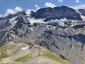
At 2.5 miles the grade briefly abates as the trail swings left (south) into a rocky bowl beneath the pass. Soon the trail resumes its steep climb through rocky meadows and then scree covered slopes to the Ammerten Pass (8,573-ft.) at 2.75 miles. The climb is accompanied by great views of the Ammertenspitz rising to the west.
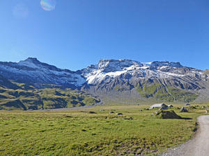
The broad pass enjoys the terrific views of the cirque ringing the Engstligenalp Valley. In the distance are a host of summits rising beyond the cirque. To the northeast Altels and the Balmhorn tower above the Kandertal valley while the Doldenhorn soars above the Gasteretal valley. On a clear day views stretch to the Bluemlisalphorn and Wyssi Frau, high peaks rising above the Oeschinensee near Kandersteg. To the south the Wildstrubel massif fills the skyline while to the southwest the Wildhorn, the Glacier del la Plaine Morte and tip of the Arpelistock dominate the view.
At this point you can turn around and retrace your steps to the trailhead for a 5.5 mile hike or continue on to the summit of the Ammertenspitz.
Ammerten Pass to Ammertenspitz
Distance from Trailhead: 6.5 miles (round trip)
Ending/Highest Elevation: 8,573-ft.
Elevation Gain: 2,138-ft.
From the pass follow the obvious trail ascending up the ridge crest (northwest) to the summit of the Ammertenspitz. The path steepens as it gains altitude. Tight switchbacks facilitate the final stiff climb to the summit.
Reach the Ammertenspitz (8,753-ft.) at 3.25 miles after gaining 558-ft. in half a mile. Here panoramic, 360-degree views encompass all the peaks previously seen from the pass along with the mountains and ridges rising around Adelboden, to the north, and Lenk area, to the west/southwest.
Signs atop the pass point to a route heading northwest toward Hahnenmoos Pass. (Routes are very challenging trails that involve some scrambling and are only recommended for surefooted hikers.) The route is best walked in the opposite direction, starting at Hahnenmoos Pass.
When you are done taking in the great views return to the trailhead for a 6.5 mile trip.
Elevation Profile
Driving Directions
From Kandersteg to Unter dem Birg and Engstligenalp: There are two options for getting to Unter Dem Birg in Adelboden. The easiest way is to take the #230 bus from the Kandersteg Bahnhof heading to Adelboden Post and get off at the Adelboden Oey stop. At Oey, walk west to the traffic circle, turn left and follow the traffic circle around to Bodenstrasse. Cross Bodenstrasse to the bus stop. (Typically a few other people on the bus are making this connection. If in doubt, tell someone you want to connect to the bus to Unter dem Birg. They can point you in the right direction.)
Catch the #232 bus to Unter dem Birg and the Engstligenalp Cable Car station (the last stop). The bus will stop right in front of the station. After purchasing a round-trip ticket, ride the cable car to Engstligenalp. The entire trip takes about one-hour and 25-minutes. Check the SBB website or download the SBB app for the current schedule and prices.
Alternatively, at the Kandersteg Bahnhof, take the train to Frutigen. At Frutigen, exit the train and then cross the street in front of the station to the bus stop. Here you catch the #230 bus to Adelboden, Oey and then follow the direction above. This option takes one-hour and 10-minutes.
From Adelboden Post to Unter dem Birg and Engstligenalp: Catch the #232 Bus to Unter dem Birg and the Engstligenalp Cable car station (the last stop). The bus stops in front of the cable car station. After purchasing a round-trip ticket, ride the cable car to Engstligenalp.
Engstligenalp to Adelboden or the Kandersteg Bahnhof: Take the cable car from Engstligenalp to Unter dem Birg. Exit the cable car and cross the street to the bus stop. Take the #232 bus, which goes all the way to Adelboden. If you wish to return to Kandersteg, get off at Adelboden Oey. Here you need to change to the #230 bus bound for Kandersteg. Walk a short distance north up the road to an intersection, turn right and then walk a short distance to the #230 bus stop. It is very likely that other people will be making this change. If you are confused, ask and people will happily point you in the right direction. Most Swiss speak english.
Parties heading to Kandersteg now have two options. You can stay on the #230 bus all the way to Kandersteg or get off the bus at the Frutigen Train Station and take the train to Kandersteg. The train is faster by 12 minutes. The bus is easier, since you don’t have to change. The ride back to Kandersteg takes between one-hour 52-minutes to two hours 4-minutes. Check the SBB website or download the SBB app for the current schedule and prices.
Trail Resources
Trail Intro / Trail Photo Gallery / Trail Map
Basecamp(s) Information:
Kandersteg
Region Information:
The Bernese Oberland
Other Hiking Regions in:
Switzerland