Details: Hohturli Pass 
Distance: 9.8 - 10.4 miles (round trip)
near Kandersteg in The Bernese Oberland
Hike Facts
- Distance: 9.8 - 10.4 miles (round trip)
- Elevation: 5,530-ft. - 9,350-ft.
- Elevation Gain: 3,584-ft. - 3,820-ft.
- Difficulty: strenuous
- Trail Highlights: See Trail Intro
- Basecamp(s): Kandersteg
- Region: The Bernese Oberland
Hikers tackling the steep, strenuous ascent to Hohturli Pass are rewarded with stunning vistas of Oeschinensee Lake, marvelous mountain scenery and close-up views of dramatic glaciers.
Hohturli Pass

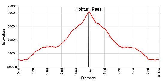
Distance from Trailhead: 9.8 miles (round trip)
Ending/Highest Elevation: 9,114-ft.
Elevation Gain: 3,584-ft.
From Kandersteg take the Kandersteg-Oeschinensee Gondola to the top station (5,530-ft.). (See trailhead directions below.) Exit the gondola station and find the hiking signs at the start of a gravel path heading east. Views from the meadows adjacent to the gondola offer previews of the coming attractions. The Oeschinenhorn, Frundenhorn and Doldenhorn fill the skyline to the east/southeast while the Bunderspitz and the Gross Lohner dominate the view to the southwest.
Walk east along the gravel path toward the Oeschinensee. In a short distance reach a “Y” intersection at Schatthaus (5,479-ft.) and take the trail branching left toward Lager, the Oeschinensee (20-min) and Hohturli (4-hr). Follow the trail as it heads east through meadows and clusters of trees, passing a few minor junctions. In all cases continue along the main trail toward Lager and the Oeschinensee.
Reach a junction at 0.6 miles and turn left on the trail toward Heuberg, Ober Bergli, Hohturli and Bluemlisalphutte, which ascends on moderately-steep to steep grades through meadows and trees, crossing a few talus slopes along the way. At 1.4 miles the grade abates as the trail reaches a grassy knoll.
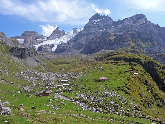
A use trail, heading south, leads to a bench atop the knoll offering a great perspective of the amazing sheer walls ringing the Oeschinensee and the rugged peaks forming the stunning glacial cirque surrounding the lake. Glaciers tumble down the cirque's rugged slopes while waterfalls, fed by glacial melt water, plummet down the sheer walls and into the lake.
Beyond the knoll the trail contours high above the north side of the lake, traveling through meadows, crossing rockslides and navigating rocky gullies along the valley’s steep, sinuous walls. Caution is required in a few spots with a little bit of exposure.
The walk is accompanied by glorious views of the Oeschinenhorn, Frundenhorn and Doldenhorn towering high above the south/east side of the Oeschinensee. As you near the head of the lake grand views open up the valley to Hohturli pass. The Bluemlisalp Glacier tumbles down the slopes between the Bluemlisalp-Rothorn, Ufem Stock and Wyssi Frau, rugged horns protruding from the flanks of the Bluemlisalp massif. If you look carefully, you should be able to see the Bluemlisalp Hut perched atop a rocky knoll to the north of the Wyssi Frau.
At 2.3 miles the trail curves to the east, crosses a stream and then curves to the south, reaching the small alp at Ober Bergli (6,473-ft.) and a trail junction at 2.7 miles. Ober Bergli is located at the foot of a hanging valley high above the northeast end of the Oeschinensee.
Turn left at the junction toward Hohturli, Bluemlisalp Hut and Griesalp. The trail to the right, which drops steeply down to Unter Bergli, offers an alternative route back to Kandersteg on return journey.
Soon the trail crosses to the north side of the stream on a metal bridge and starts climbing, making a wide arc around the alp’s pastures to avoid a field strewn with boulders from an old rock slide. At 3.0 miles the trail curves to the left (east/northeast) and ascends steeply through rocky meadows along the north side of the valley.
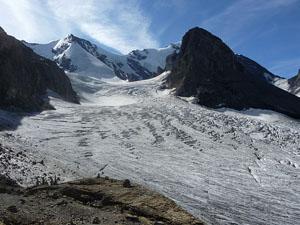
At 3.5 miles the path climbs a series of switchbacks ascending to the knife-edge crest of the eroded moraine of the Bluemlisalp Glacier. To the south enjoy wonderful views of the tongues of the Bluemlisalp glacier hanging from a high shelf. Unfortunately the receding glacial tongues are not quite a dramatic as they were 10-15 years ago.
Follow the trail as it climbs on moderately steep grades along the crest of the moraine. Turn around occasionally for nice views of the peaks, including the Gross Lohner, rising along the west side of Kandersteg. At 3.9 miles the moraine wall ends and the trail now ascends on moderate to moderately-steep grades through meadows and up rock ledges along the north side of the deep trench filled with the rocky remains of the receding glacier. The pass, a notch along ridge at the head of the valley, and the hut, to the right (south) of the pass, are now in sight.
At 4.5 miles the path curves to the east and the rocky meadows give way to scree covered slopes. Follow the trail as it climbs steep to very steep grades toward the pass, gaining over 1,000-ft in 0.75 miles. In places temporary bridges span eroded gullies along the trail. The final push to the pass climbs very steeply up wood steps.
Reach Hohturli Pass (9,114-ft.) at 4.9 miles and a 3,584-ft. elevation gain. From the pass great views extend southwest to the peaks towering above the west side of Kandersteg. Sefinenfurgge Pass, the notch on the saddle between the Hundshorn and Butlasse, is visible to the east. To the north, fine views stretch down the length of the Kiental Valley to Lake Thun and beyond. To the south, dazzling glaciers spill down the flanks of the Bluemlisalp massif.
Bluemlisalp Hut and Overlook
Distance from Trailhead: 10.4 miles (round trip)
Ending/Highest Elevation: 9,350-ft.
Elevation Gain: 3,820-ft.
For even better views of the glacier, turn southeast and climb steep switchbacks up to Bluemlisalphutte (9,297-ft.). Reach the hut, which offers dormitory accommodations and meals, at 5.1 miles. A use trail, skirting the southwest side of the hut, crosses a large boulder field and then scree-covered slopes on its way to great viewpoints (9,350-ft.) overlooking the Bluemlisalp Glacier at 5.2 miles. Here you have a bird’s-eye view of motionless rivers of ice flowing around the Utem Stock, a horn protruding from the flanks of the Bluemlisalp massif.
When you are done taking in the views, retrace your steps to the gondola. For variety, you can take an alternate trail from Ober Bergli back to the gondola. At Ober Bergli take the trail branching left (west/southwest) toward the Oeschinensee (45-min) and Kandersteg (1-hr 45-min). This route drops steeply down to Unter Bergli (5,797-ft.) and then follows a descending traverse along the north side of the Oeschinensee to Chuematti and Lager at the foot of the lake. Beyond Lager the trails ascends to the lift station where a gondola whisks hikers down to Kandersteg.
Alternatively if you prefer to walk back to Kandersteg, at Chuematti turn left (east/southeast) on the trail headed toward Kandersteg (1-hr 10-min). The trail descends steeply through meadows and then travels along the Oschibach, a pleasant stream with nice views of the steep walls lining the south side of the valley. Reach Kandersteg (3,858-ft.) after hiking 2.8 miles and losing about 1,400-ft from Chuematti. Total hiking distance to Hohturli, taking the gondola up and walking down is 11.5 miles.
There is also a trail to Kandersteg that starts at the top of the gondola and drops down steep switchbacks beneath the gondola. The trail descending along the Oschibach is the better option.
Elevation Profile
Driving Directions
From the Kandersteg Bahnhof (train station) to the Kandersteg-Oeschinensee Gondola: From the front of the train station, walk south a short distance and then turn left (east) onto Bahnhofstrasse (Train Station Street). Walk about 700-ft. east on Bahnhofstrasse and turn left (north) on Dorfstrasse (the town’s main street). Walk about 650-ft. along Dorfstrasse, passing two streets on the right. Just before the second street you'll go by the Kandersteg Tourism Office on your right, a good place to stop to pickup maps and town information.
A short distance beyond the second street, turn right on a paved walkway heading east through beautiful meadows. The Hotel Bernerhof is directly across from the meadow. Walk a little over 0.3 miles on the pavement to Oschistrasse, passing a pretty little chapel on your right along the way. Turn left on Oschistrasse and walk about 360-ft. to the Kandersteg-Oeschinensee Gondelbahn (gondola). The gondola ride to the top station takes about nine minutes.
See Kandersteg-Oeschinensee Gondelbahn website for the current schedule.
Trail Resources
Trail Intro / Trail Photo Gallery / Trail Map
Basecamp(s) Information:
Kandersteg
Region Information:
The Bernese Oberland
Other Hiking Regions in:
Switzerland