Details: Engstlenalp to Meiringen 
Distance: 6.4 miles (one way)
near Meiringen in The Bernese Oberland
By: Diane Greer
Hike Facts
- Distance: 6.4 miles (one way)
- Elevation: 6,017-ft. - 7,365-ft.
- Elevation Gain: 1,382-ft.
- Difficulty: moderate-strenuous
- Trail Highlights: See Trail Intro
- Basecamp(s): Meiringen / Engelberg
- Region: The Bernese Oberland
The beautiful hike from Engstlenalp to Planplatten visits the scenic Tannersee, enjoys terrific views atop the Balmeregghorn and then travels to the overlook at Planplatten with panoramic vistas of the high peaks towering above four valleys.
Engstlenalp to Balmeregghorn
Distance from Trailhead: 4.5 miles (one way)
Ending/Highest Elevation: 7,398-ft.
Elevation Gain: 1,382-ft.
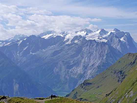
Find the trail signposts in front of the Hotel Engstlenalp in Engstlenalp (6,017-ft.). (See trailhead directions below). Follow the broad track heading northwest toward Tannalp (45-min), Balmeregghorn (2-hr 30-min) and Planplatten (3-hr 45-min) as it travels through pastures and passes the houses and barns of Engstlenalp. In the distance the high peaks towering above Reichenbach and Grindelwald valleys, including the Wellhorn, Wetterhorn and Schreckhorn, dominate the view to the southwest. The Wendenstocke, Tallistock and the rugged intervening ridge fills the skyline across the Gental Valley while the Jochstock and Titlis rise to the east.
At 0.2 miles the trail curves to the left (west) and soon crosses a stream (0.5 miles) beneath a beautiful waterfall cascading down a rock face above the trail. Beyond the stream the trail ascends on moderate grades up a hillside beneath rugged cliffs toward Tannalp. As you climb, enjoy ever improving views of the peaks and ridges seen from the Hotel Engstlenalp.
At 0.7 miles a trail branches left toward Baumgartenalp, Hasliberg and Reuti. We continue along the main path toward Tannenalp, Balmeregghorn and Planplatten. Fixed ropes along the path facilitate the climb up a rocky section of the trail along the Spycherflue, a 260-ft. tall rock wall. This section of the trail could be problematic if covered with ice or slick snow.
At 1.1 miles the trail curves to the right (northwest) and reaches the ridge crest after a final short, steep climb. The path now continues ascending on moderate grades across the pastures of Tannenalp. Soon views open to the hamlet of Tannalp, situated beneath the rugged ridge extending southwest from the Barglen Schiben.
At 1.4 miles the grade abates as the trail curves around a grassy bowl. As you near the buildings of Tannalp views open to the distinctively shaped Graustock to the northeast. Titlis, the Jochstock and Wendenstocke rise above the grassy slopes to the southeast.
Reach a road junction at Tannalp (6,486-ft.) at 1.6 miles. Turn left (southwest) toward the Tannersee (10-min), Balmeregghorn (1-hr 25-min) and Planplatten (2-hr 35-min) on a paved alp road ascending gently through pastures.
At 2.0 miles reach the eastern end of the Tannersee. Here the road curves to the right (west), along the north shore of the Tannersee toward the Melchsee-Frutt. We take the trail branching left (southwest) that skirts the lake’s southeastern shore. To the west, the Rothorn and Glogghus tower above the valley beyond the Tannersee.
Reach a junction at the southeastern end of the lake where another trail branches right toward Melchsee-Frutt on a path winding along the lake’s south shore. We bear left on the trail heading for Erzegg, Balmeregghorn and Planplatte (aka Planplatten). The path travels through rolling pastures on easy grades and soon joins a broad track that climbs switchbacks up a grassy slope to a cross atop a ridge.
The scenic ridge enjoys marvelous 360-degree views. To the northeast/east the peaks and ridges rising above the Tannersee and Tannalp dominate the view. To the southeast are great views of the summits towering above Engstlenalp. To the south across the Gental valley, the ridge between the Wendenstocke and Tallistock fills the skyline. To the northwest the Rothorn, Glogghus and Hochstollen punctuate the rugged ridge along the west side of the Melchsee valley while to the southwest the high peaks and glaciers of the Bernese Alps form the backdrop for the Balmeregghorn.
Beyond the cross follow the trail, marked with red and white stakes, heading southwest along an undulating landscape atop the ridge. In places fencing along the southeast side of the ridge keeps livestock and hikers off eroded sections of the ridge crest.
At 3.9 miles the trail makes a short, steep descent to a junction at 4.0 miles where a trail branches to the right (north) to Melchsee-Frutt. We continue along the grassy ridge, following the trail as it climbs steep to moderately-steep grades to an overlook at the summit of the Balmeregghorn (7,398-ft.) at 4.5 miles. This is a great place to take a break and enjoy the splendid panoramic views in all directions.
Balmeregghorn to Planplatten (Meiringen)
Distance from Trailhead: 6.4 miles (one way)
Ending/Highest Elevation: 7,365-ft.
Elevation Gain: -567-ft.
After taking in the views atop the Balmeregghorn continue on the trail as it descends along the ridge and soon reaches a signed junction with a path branching right toward Melchsee-Frutt and the top station for a chairlift in the Melchsee valley. We continue along the ridge in the direction of Planplatten (1-hr 15-min), Reuti (3-hr 50-min) and Meiringen (5-hr). Planplatten is now visible to the southwest.
The trail descends steeply, traveling around a bowl beneath the rugged southeast flanks of the Rothorn. Beyond the bowl ascend on moderate grades up a narrow trail clinging to the Lauber’s steep slopes. The trail seems exposed in places but is quite safe.
At 5.4 miles the grade briefly abates as the trail curves around a minor ridge. Beyond the ridge the path descends on moderately-easy grade along steep slopes, crossing several rockslides. The section of the trail is accompanied by great views of the peaks rising above the Gadmertal (Gadmer Valley) to the south.
At 5.8 miles the trail begins an easy traverse along the ridge leading to Planplatten. The trail drops down to and crosses a saddle on the ridge at 6.2 miles where a trail branches left (south) toward Schlafenbielen, Hasliberg and Reuti. Soon a second trail branches right (north) toward Magisalp, Reuti and Meiringen. Ignore both trails and continue along the ridge, climbing moderately steep grades to Planplatten (7,152-ft.) at 6.4 miles.
An overlook along the ridge just beyond Planplatten (7,365-ft.) offers an amazing panorama of the area’s peaks and valleys. To the west the aquamarine waters of Lake Brienz lie cradled in a massive bowl at the foot of the Haslital valley. To the east the Sustenhorn towers over Sustenpass at the head of the Gadmertal while the Dammastock rises above the Trift Glacier to the south of the Sustenhorn. To the southwest, the Wetterhorn looms above the green meadows of Grosse Scheidegg while behind you to the northeast the Tallistock and Wendenstocke define the southeast wall of the Gental with Jochpass at its head.
Hikers now have the option of taking the gondola from Planplatten to Reuti, with several changes required at mid stations, or walking down to Reuti. If you plan to hike to Reuti, walk to the viewpoint at Planplatten where signs point straight ahead to Gummenalp (1-hr) and Reuti (2-hr 10-min). The trail drops down the ridge and then turns right, descending on steep switchbacks through meadows and clusters of trees, losing over 3,800-ft. in 4.6 miles on its way to Reuti. The path is obvious. If you are not sure which way to turn at an intersection, always head toward Reuti and in the direction of the green and blue Via Alpina signs with the number “1”. Total hiking distance from Engstlenalp to Reuti is 11.0 miles.
At Reuti a cable car descends to Meiringen. Hiker who wish to walk should follow a well marked trail that drops steeply through pastures and forested hillsides, losing over 1,500-ft. in 2.0 miles on the way to Meiringen.
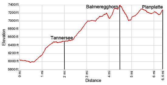
Elevation Profile
Driving Directions
From Meiringen: Unfortunately, SBB no longer runs post buses to Engstlenalp. Check out the Engstlenalp website for the latest travel options. On our last visit, Frutt Taxi ran a van twice a day to / from Engstlenalp. Other options to book directly include Alpen Bus/Taxi and Grimsel Taxi.
At Planplatten the gondola descends in 3 stages; Alpen Tower (Planplatten) to Magisalp, Magisalp to Bidmi and Bidmi to Reuti. At Reuti a cable car descends to Meiringen. See the Bergbahnen Meiringen-Hasliberg website for the current schedules and prices.
Trail Resources
Trail Intro / Trail Photo Gallery / Trail Map
Basecamp(s) Information:
Meiringen / Engelberg
Region Information:
The Bernese Oberland
Other Hiking Regions in:
Switzerland