Details: Fluela – Schwarzhorn - Durrboden 
Distance: 6.4 - 8.1 miles (one way)
near Davos in Eastern Switzerland
Hike Facts
- Distance: 6.4 - 8.1 miles (one way)
- Elevation: 7,817-ft. - 10,318-ft.
- Elevation Gain: 2,501-ft.
- Difficulty: strenuous-difficult
- Trail Highlights: See Trail Intro
- Basecamp(s): Davos
- Region: Eastern Switzerland
This epic hike summits the Schwarzhorn, crosses two panoramic passes and visits four scenic valleys in route to Durrboden. Highlights include the high peaks towering above the Lower Engadine, the cirque at the head of the Grialetsch Valley and the summits rimming the Dischma, Funtauna and Tschuvel Valleys.
Trailhead to the Summit of the Schwarzhorn
Distance from Trailhead: 2.3 miles (one way)
Ending/Highest Elevation: 10,318-ft.
Elevation Gain: 2,501-ft.
(Note: The Schwarzhorn in Davos is often referred to as the Fluela Schwarzhorn to distinguish the peak from the Schwarzhorn in the Valais.)
Start the day by taking the bus from Davos to the Schwarzhorn trailhead, located along the Fluelapass (Fluela Pass) road. (See trailhead directions below.) Get off the bus at the first stop after Fluelapass (east side of the pass). The stop and the trailhead are located along the south side of the road.
Note for hikers driving to the trailhead: There is limited parking at the trailhead. If the lot is full, turn around and park at Fluela Pass. A 0.6 mile (one-way) trail, traveling above the north side of the Fluelapass Road, leads to the Schwarzhorn trailhead. Follow the trail signed for the Schwarzhorn, Fuorcla Radont, Grialetschhutte and Durrboden. This description assumes you are starting at the bus stop. If starting at the pass, add 0.6 miles (one-way) to the mileage in the description below.
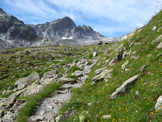
At the trailhead, walk southeast on the trail signed for Schwarzhorn, Fuorcla Radont, Grialetschhutte and Durrboden. The trail immediately starts climbing on moderately-steep to steep grades through rocky meadows and intermittent scree. Along the way pass a junction with a trail branching left. We continue on the trail to the Schwarzhorn. Behind you (north) the Fluela Wisshorn towers above the Fluelapass road.
At 0.3 miles the trail climbs a few steep switchbacks and then swings to the right (southwest), entering the Radont Valley rimmed with a cirque anchored by Piz Radont, the Raduner Rothorn and the Schwarzhorn. The path now ascends on moderately-steep to steep grades beneath the east facing slopes of the Schwarzhorn accompanied by great views of Piz Radont to the south.
Reach a junction at 0.5 miles with a trail branching left (south) toward Fuorcla Radont and the Grialetschhutte. We continue on the trail to the Schwarzhorn.
Beyond the junction views open to the Raduner Rothorn and Fuorcla Radont (Radont Pass), the saddle on the ridge to the northeast of Piz Radont. Soon the Schwarzhorn (10,318-ft.) joins the scene. Below the trail a stream winds down the valley floor.
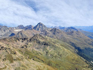
At 1.0 mile the path starts climbing switchbacks. Soon the meadows give way to scree covered slopes. Turn around occasionally to appreciate the fine views stretching northeast to Piz Linard and the peaks towering above the Fluelapass Road and the Lower Engadine Valley.
The grade steepens as the path ascends tight switchbacks up the rugged slopes beneath the Schwarzhornfurgga (Schwarzhorn Pass). Here views open to the Schwarzhorn’s south ridge, the route to the summit.
At 1.6 miles reach a junction with a trail branching left (east) toward Fuorcla Radont. Large rocks around the junction provide convenient resting places before continuing the ascent.
After taking a break continue straight ahead toward the Schwarzhorn, reaching the Schwarzhornfurgga at 1.75 miles. From the pass views stretch west to the high peaks rimming the Dischma Valley and beyond. Behind you the summits rising above the Lower Engadine valley fill the skyline.
Turn right and follow the trail as it climbs very steep switchbacks up the south ridge to the summit of the Schwarzhorn (10,318-ft.) at 2.3 miles. Initially the trail has some minor exposure but soon the ridge widens and the remainder of the stiff climb to the top is on a good, albeit very steep, trail.
From the summit enjoy breathtaking, panoramic views that extend northwest down the Dischma Valley to Davos. The Fluela Wisshorn and nearby peaks tower above Fluela Pass to the north. Piz Linard soars above a sea of peaks rising above the Lower Engadine Valley to the east. The Piz Sarsura massif, Piz Vadret and the Grialetsch Glacier are seen beyond Piz Radont to the south. Piz Kesch, the Porchabella Glacier and the summits rimming the upper Dischma, Funtauna and Tschuvel valleys grace the skyline to the southwest.
To Fuorcla Radont
Distance from Trailhead: 4.3 miles (one way)
Ending/Highest Elevation: 9,137-ft.
Elevation Gain: 380-ft.
Note: This segment of the trail loses 1,560 feet descending from the Schwarzhorn and then gains 380-ft. climbing to Fuorcla Radont.
When you are done taking in the views atop the Schwarzhorn, descend from the peak and return to the junction with the trail to Fuorcla Radont at 3.0 miles. Turn right (east) at the junction and follow the trail as it descends into the rocky bowl beneath the Raduner Rothorn and Piz Radont.
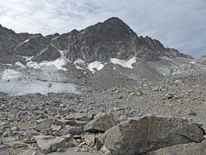
The path crosses the stark bowl containing the rocky remains from the receding Rothorn Glacier. The remnants of the glacier cling to the slopes beneath Piz Radont. The rugged bowl is strewn with boulders and dotted with small tarns. Red and white slashes on the rock keep you on track.
The hike through the bowl is accompanied by fine views stretching north/northeast from the Fluela Wisshorn to Piz Linard. Behind you, to the west, the Schwarzhorn soars above the bowl. Piz Radont looms above the trail to the south.
At 3.5 miles the trail passes along the south shore of a scenic tarn. Soon the path goes over a small hump and reaches a junction at 4.0 miles. Turn right (southeast) on the trail climbing steeply to Fuorcla Radont (Radont Pass) at 4.25 miles. As you crest the pass great views open to the peaks rimming the east side of the Grialetsch Valley and the splendid cirque at the head of the valley, anchored by Piz Grialetsch, Piz Vadret and Piz Sarsura. The Grialetsch Glacier spills down the slopes of the cirque. Behind you are more fine views of the Schwarzhorn.
From the pass you can drop down the east side of the Radont Valley to Fluela Pass area on a trail losing over 1,300-ft. in just under 2.2 miles for a 6.4 miles loop or continue over the pass to Fuorcla Grialetsch and Durrboden. If time and energy allow, I recommend continuing to Durrboden.
Fuorcla Radont to Fuorcla da Grialetsch to Durrboden
Distance from Trailhead: 8.1 miles (one way)
Ending/Highest Elevation: 6,620-ft.
Elevation Gain: -2,562-ft.
From the Fuorcla Radont the trail descends on easy to moderate grades down the south side of the pass to a grassy knoll with more great views of the Grialetsch cirque. Beyond the knoll the trail soon reaches and crosses a boulder field before dropping down to a bench beneath the east facing slopes of Piz Radont at 4.9 miles.
The grade abates as the path crosses the bowl, reaching the end of the bench at 5.35 miles. Here views open to the Fuorcla da Grialetsch (Grialetsch Pass) area set amid pretty meadows beneath the rugged slopes of the Chilbiritzenspitz. Two lovely tarns lie nestled in the meadows.
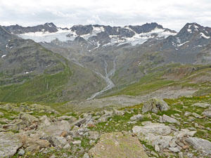
The path now descends on steep grades to Fuorcla da Grialetsch (8,320-ft.) and a trail junction at 5.7 miles. To the east are great views of Piz Vadret, the Piz Sarsura massif and the Grialetsch Glacier.
From the junction a trail wanders south to the Grialetsch Hut with more great views of the Grialetsch Glacier and the Piz Sarsura massif along with the beautiful meadows and tarns around the Grialetsch Hut. The hut offers dormitory accommodations and refreshments.
After exploring the area round the hut return to the junction and head west toward Durrboden. The trail descends on gentle grades down the Furgga Valley to the Furggasee (Lake Furgga), a pretty tarn set beneath the south facing slopes of the Raduner Rothorn and Piz Radont at 6.1 miles.
The path traverses the south shore of the lake and then drops steeply down rocky meadows along the north side of the Furgga Valley. The Furggabach (Furgga stream) spills down the valley floor beneath the trail. The rugged slopes of the Raduner Rothorn tower above the trail to the north. Along the way views open southwest to the Chuealphorn, Augstenhureli and Leidhorn rising above the Scaletta Pass area.
At 7.0 miles the trail curves to the right (northeast) and reaches a junction with a trail branching left toward Scaletta Pass. We continue on the trail descending to Durrboden. Behind you are fine vistas of the Scaletta Glacier clinging to the rugged slopes ringing the Gletschtalli Valley. Ahead views open to a cluster of buildings at Durrboden.
The grade moderates at 7.5 miles as the trail descends through meadows to the east of the Furggabach. Near Durrboden we pass a junction with a trail heading up the Dischma Valley to Scaletta Pass. A short distance beyond we reach the Bergghaus at Durrboden at 8.1 miles.
The historic Berghaus includes a nice restaurant with lovely views of Piz Grialetsch, the Scalettahorn, the Scaletta Glacier and nearby peaks rising above the Gletschtalli. The Raduner Rothorn and Schwarzhorn tower above the east side of the valley. Go around the front of the building to find the bus stop and schedule for the buses returning to Davos.
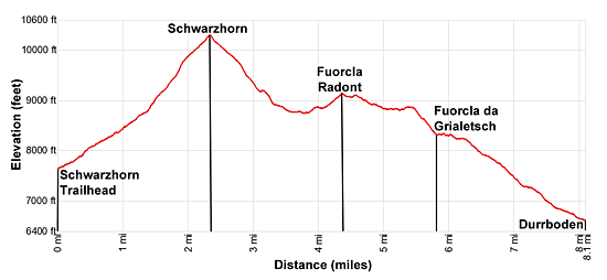
Elevation Profile
Driving Directions
From the Davos Dorf Bahnhof: Take the #331 bus heading toward Susch and get off at Susch, Abzw. Schwarzhorn. (Abzw. is an abbreviation for Abzweigung or junction.) This is the first stop after Fluela Pass (east side of the pass). The trailhead is located on the south side of the highway. The ride should take 24 minutes. You can check the current schedules at the SBB website/SBB app.
Note: If you are driving, there is limited parking at the trailhead. If the lot is full, turn around and park at Fluela Pass. From the pass, locate the trail at the northeast end of the parking area. The trail traverses the north side of the Schwarzsee, a lake, and then travels along the slopes above the north side of the highway to the Schwarzhorn trailhead in 0.6 miles.
Durrboden to Davos: Find the bus stop in front of the Berggasthaus at Durrboden. Take the #12 bus bound for Davos Dorf Bahnhof (train station at the northeast end of town) at get off at the train station (the last stop). The ride takes about 32 minutes. A bus schedule is posted at the bus stop of Durrboden. You can also check the current schedules at the SBB website/SBB app.
Note: Buses and trains travel between Davos Dorf and Davos Platz. The train ride takes 3 minutes. Buses take a variety of routes through the town. Pick up a bus schedule at the Tourism Office at the Davos Dorf Bahnhof or near the Sportzentrum in the middle of town, or check the current schedules at the SBB website/SBB app to find the route closest to your accommodations.
Trail Resources
Trail Intro / Trail Photo Gallery / Trail Map
Basecamp(s) Information:
Davos
Region Information:
Eastern Switzerland
Other Hiking Regions in:
Switzerland