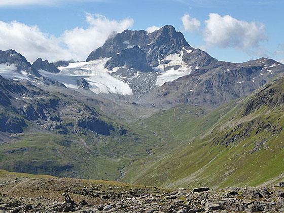
Close-up of Piz Kesch from Sertig Pass
This terrific hike crosses two panoramic passes, Sertig Pass and Scaletta Pass, and travels through five scenic valleys. Along the way hikers enjoy splendid views of Piz Kesch, Piz Vadret, the Ducan Ridge, the Schwarzhorn and the Chuealphorn, to name a few.
See Trail Detail/Full Description
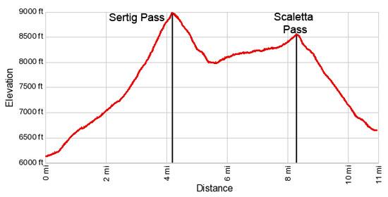
- Distance: 4.2 miles (one way) to Sertig Pass
8.3 miles (one way) to Scaletta Pass
11.0 miles (one way) to Durrboden - Elevation: 6,099-ft. at Trailhead
8,986-ft. at Sertig Pass
8,550-ft. at Scaletta Pass
6,620-ft. at Durrboden - Elevation Gain: 2,887-ft. to Sertig Pass
540-ft. to Scaletta Pass
-1,930-ft. to Durrboden - Difficulty: strenuous
- More Hikes in:
Davos / Eastern Switzerland
Why Hike Sertig to Durrboden
This splendid hike crosses two scenic passes linking the German-speaking Davos region with the Romansh Upper Engadine. Along the way the trail traverses five beautiful valleys clad in pretty meadows and ringed by high peaks draped with glaciers.
Starting in Sertig Sand, the hike ascends the beautiful Chuealp Valley to Sertig Pass where views open to Piz Kesch, the highest peak in the Albula Alps, soaring above the Val dal Tschuvel. The serrated peaks of the Ducan Ridge dominate the view to the west.
Beyond the pass the trail drops down the Val Sartiv and then traverses the Val Funtauna beneath the flanks of the Chuealphorn. Fantastic views of the Piz Vadret massif, soon joined by Piz Grialetsch to the northeast, accompany the delightful walk through meadows sprinkled with wildflowers.
As the trail turns into the Val Susauna and climbs toward Scaletta Pass views open of the high peaks towering above the valleys to the southwest. Soon the trail crests Scaletta Pass and the distinctive triangular-shaped Schwarzhorn, the highest peak in the Davos area, bursts onto the scene.
A good trail now descends through rocky meadows and scree-covered slopes to the floor of the Dischma Valley, accompanied by great views of the Raduner Rothorn and Piz Redont. As the trail reaches the valley floor the panorama of peaks, including Scaletta Peak and Piz Grialetsch, along with the Scaletta Glacier, will make you wish you had rear view mirrors. The problem is easily solved by frequently turning around to enjoy the marvelous views.
The hike ends at Durrboden, a small alp with a Berghaus and restaurant. Before returning to Davos by postbus find a nice perch on the restaurant’s scenic sun terrace for a much deserved drink and snack.
This is a long hike with a fair amount of up and down. I strongly recommend getting an early start and catching the first postbus of the day to Sertig Sand. This will give you ample time to enjoy the beautiful hike and still arrive in Durrboden in time to catch the last bus back to Davos.
At the time of this writing the postbus between Davos and Durrboden ran seven times a day with the last bus returning to Davos at 6:30pm. These times are subject to change. Check the current schedules at the SBB website/SBB app.
Elevation Profile
| Support our Site |
Trail Resources
Trail Detail/Full Description / Trail Photo Gallery / Trail Map
Basecamp(s) Information:
Davos
Region Information:
Eastern Switzerland
Other Hiking Regions in:
Switzerland