Guarda to Ardez via Furcletta Pass 
Distance: 9.0 - 13.5 miles (one way)
near Scuol in Eastern Switzerland
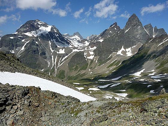
Piz Fliana, the Verstanclahorn and Piz Buin
This long, demanding hike visits three scenic valleys and crosses a panoramic pass with splendid views of the high peaks of the Silveretta and Engadine Dolomite Alps.
See Trail Detail/Full Description
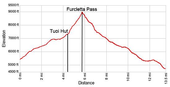
- Distance: 9.0 miles (round trip) to Tuoi Hut
11.4 miles (round trip) to Furcletta Pass
13.5 miles (one way) to Ardez (Complete Hike) - Elevation: 5,424-ft. at Trailhead
7,382-ft. at Tuoi Hut
8,973-ft. at Furcletta Pass
4,708-ft. at Ardez (Complete Hike) - Elevation Gain: 1,958-ft. to Tuoi Hut
3,549-ft. to Furcletta Pass
-4,265-ft. to Ardez (Complete Hike) - Difficulty: strenuous
- More Hikes in:
Scuol / Eastern Switzerland
Why Hike Guarda to Ardez via Furcletta Pass
Serious hikers will love this long, strenuous walk with knockout views of the high peaks of the Silveretta and Dolomite Engadine Alps. The hike starts with a beautiful walk up the Tuoi Valley, traveling through flower filled meadows to Chamanna Tuoi (Tuoi Hut). From the hut enjoy fine views of Piz Fliana rising above the west side of the valley while Piz Buin, Piz Jeramias and the Dreilanderspitz, straddling the Swiss-Austrian border, tower above the valley.
From the hut the trail turns east and ascends steeply through meadows where views open to the Tuoi Glacier, cradled in a bowl beneath the Dreilanderspitz, Hinter Jamspitz and Piz Tuoi. The path then climbs steeply through scree, boulders and snow fields to Furcletta Pass, with dramatic views of the jagged peaks rising above the west side of the Tuoi valley and beyond. To the east, fine views extend down the Val d’Urezzas to Piz Minschun towering about the east side of the Val Tasna.
Beyond the pass the trail drops steeply down scree-covered slopes that give way to pretty meadows beneath a beautiful cirque towering above the north side of the Urezzas valley. The trail then descends along the north side of the valley to the head of Val Tasna. Here the path turns south and descends through meadows and forests accompanied by superb views of the Dolomite Engadine range rising above the south side of the Lower Engadine Valley.
This is a very long and strenuous hike gaining over 3,500-ft. on the climb to the pass and then dropping over 4,200-ft. to Ardez. Get an early start and allocate 7-8 hours to complete the walk, depending on you pace and the number of stops along the way.
An out-and-back hike to the Tuoi Hut offers hikers a shorter and less strenuous day while still enjoying the scenic delights of the Tuoi Valley.
Elevation Profile
| Support our Site |

Trail Resources
Trail Detail/Full Description / Trail Photo Gallery / Trail Map
Basecamp(s) Information:
Scuol
Region Information:
Eastern Switzerland
Other Hiking Regions in:
Switzerland