Details: Col de Torrent: Les Hauderes to Lac de Moiry 
Distance: 7.3 miles (one way)
near Les Hauderes in The Valais
Hike Facts
- Distance: 7.3 miles (one way)
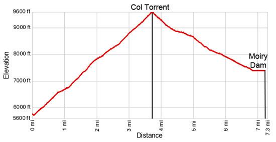
- Elevation: 5,716-ft. - 9,576-ft.
- Elevation Gain: 3,860-ft.
- Difficulty: strenuous
- Trail Highlights: See Trail Intro
- Basecamp(s): Les Hauderes
- Region: The Valais
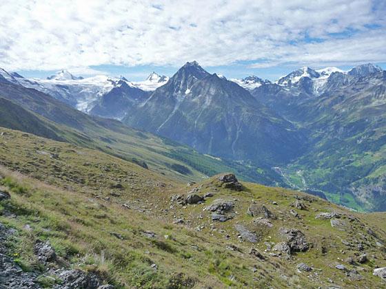
Hikers making the steep climb over the Col de Torrent from La Sage, Villaz to Lac de Moiry are rewarded with splendid views of the high peaks and glaciers towering above the Val d’ Herens, Val d' Arolla and the Val de Moiry.
La Sage, Villaz to Col Torrent
Distance from Trailhead: 3.7 miles (one way)
Ending/Highest Elevation: 9,576-ft.
Elevation Gain: 3,860-ft.
The trail from Les Hauderes to the Col de Torrent is 5.9 miles and gains of almost 4,800-feet. If you are a purist and wish to walk the entire way – go for it. Otherwise, I strongly recommend taking the bus from the Les Hauderes Post to La Sage, Villaz. The six minute ride reduced the distance by 2.2 miles and eliminates 900-ft. from the climb. It also allows you to get to the pass earlier in the day, always a good idea for the best views and to beat the clouds that typically build in the afternoons. (See trailhead directions below.)
From the bus stop in the small village of La Sage Villaz, walk back down the main road about 150-feet and turn left (northeast) on a road with hiking signs pointing toward Mayens de Cotter (50-min), Col de Torrent (3-hr 15-min) and Moiry Barrage (dam) (4-hr 45-min). At the next intersection turn right in the direction of Col de Torrent and Grimentz. Shorty beyond the turn the road curves to the left (northeast) and starts climbing steeply through pastures. As you ascend views open to Pigne d’ Arolla (12,454-ft.) at the head of the Arolla Valley to the southwest.
Soon the road curves to the right (northwest) and changes to a dirt track. At 0.4 miles reach a junction where you continue straight ahead on a road ascending along the right (southeast) side of a small stream. (Do not turn left on the road crossing the stream).
Where the road makes a hairpin curve to the right, we bear slightly left on a trail that continues ascending alongside the creek. A wood sign at the junctions points toward the Col de Torrent and Cotter.
Soon the trail crosses the creek on a wood bridge and then curves to the right (north/northeast) zig-zagging steeply up the hillside through pretty pastures. Views open southeast to Dent Blanche and the massive glacier field at the head of the Val d’Herens.
Pass a junction with a minor trail branching to the left (north) toward Cotter and Volovron at 0.6 miles. Continue on the main trail ascending toward the Col de Torrent.
At 0.8 miles turn right (east) onto a gravel road and travel a short distance along the road as it skirts the north side of a stone house. Past the house, where the road curves to the left, a signed trail branches left toward the Col de Torrent. Follow the trail as it climbs on moderate grades through pastures, cutting off a long switchback on the road. As you climb, enjoy stunning views of the high peaks and glaciers at the head of the Val d’Herens and the Arolla Valley to the south.
Reach Mayens de Cotter, a small hamlet, and the continuation of the road at 1.1 miles. Turn left on the road in the direction of Cotter (5-min), Beplan (1-hr 15-min) and the Col de Torrent (2-hr 15-min). Pass two houses on the left (south) side of the road. Just before reaching a house on the right (north) side of the road, take the trail branching to the right (northwest) signed for the Beplan, Col de Torrent and Moiry Barrage (dam).
The trail now climbs through pastures in a northerly direction on long, steep switchbacks. As you ascend, splendid views open to Les Aiguilles Rouges d’Arolla, a ridge of jagged peaks along the west side of the Arolla Valley. To the north Les Diablerets rises above the Rhone Valley.
At 1.9 miles arrows on a rock insure your follow the trail as it curves to the left (northwest). The grade now eases a bit as the path continues its ascent up the east side of the valley. Ahead is a cross mounted on a rock outcropping. Soon views open to the ridge separating the Val d’Herens and the Val de Moiry. The peak rising to the north on the ridge is Sasseneire. The saddle of the ridge to the southeast of Sasseneire is the Col de Torrent.
The trail curves to the right at 2.3 miles, heading northeast toward the ridge. Reach a small pond at Beplan (8,320-ft.) at 2.6 miles. Follow the trail as it skirts the east side of the pond and soon curves to the right (northeast), ascending steeply toward the pass. At 3.3 miles start the final steep climb to the pass on a series of tight switchbacks ascending through rocky meadows and scree covered slopes.
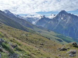
Reach the Col de Torrent (9,576-ft.) at 3.7 miles. Here a magnificent panorama of high peaks, including the Grande Dent De Veisivi, Mont Brule, Pigne d’Arolla, Les Aiguilles Rouges d’Arolla, Mont Blanc de Cheilon and the Grand Combin, dominate the view to the southwest. Dent d’Herens peeks above the Glacier de Ferpecle and Glacier du Mont Mine flowing down the flanks of the Tete Blanche at the head of the Val d' Herens. To the east the Weisshorn looms above the low ridges lining the eastern wall of the Moiry Valley. Below the east side of the pass Lac de Autannes glistens in the sun.
Col Torrent to Lac de Moiry
Distance from Trailhead: 7.3 miles (one way)
Ending/Highest Elevation: 7,381-ft.
Elevation Gain: -2,190-ft.
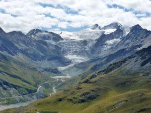
When you are ready to continue the hike, follow the trail as it drops steeply down the east side of the pass. Soon views open to the peaks and glaciers on the ridge rimming the east side of the Moiry Valley and, beyond the ridge, the Val de Zinal. At 4.4 miles the grade eases as the trail passes to the north of the Lac des Autannes. The lake enjoys wonderful views of Dent Blanche, the Grand Cornier and the Glacier de Moiry spilling down the cirque at the head of the Val de Moiry. The lake is a popular picnic spot and a great place to take a break.
Beyond the lake the views toward the head of the valley continue to expand and improve. At 5.0 miles the grade steepens as the trail drops through pretty meadows and passes a small stone house. Reach the farm of the Alpage de Torrent at 5.5 miles. Here a trail splits off the right (south/southeast) toward the head of the Lac de Moiry, the Moiry Glacier and the Cabane de Moiry. We continue straight ahead toward the Moiry Barrage (50-min) and Grimentz (2-hr 20-min).
Soon the trail joins a farm road descending on moderate grades toward the Lac de Moiry. At 5.8 miles the road swings to the left (northeast), and continues its descent to the dam at the foot of the lake. Reach the western end of the Barrage de Moiry (7,381-ft.) at 6.8 miles. Here signs point north to a trail dropping steeply down to Grimentz (1-hr 40-min), losing over 2,250-ft. in 3.8 miles.
We turn right (east) and cross the top of the dam on a wide paved road. Reach the cafe and bus stop at the eastern end of the barrage at 7.2 miles. During the summer regularly scheduled buses depart for Grimentz, Zinal and the head of Lac Moiry.
The hike can be extended by hiking down to Grimentz from the dam and/or walking up from Les Hauderes to La Sage, Villaz. Another option is to hike to the Cabane de Moiry (Moiry Hut). This strenuous route splits off from the farm (Alpage de Torrent) and then drops down to the head of the Lac de Moiry before climbing to the Cabane for a 9.59 mile hike that gains an additional 1,800-ft. on the climb to the hut. The climb to the hut can be quite tiring at the end of a long day. See the Les Hauderes to the Cabane de Moiry via the Col de Torrent for more information.
Elevation Profile
Driving Directions
From Les Hauderes Centre: Take Bus 383 in the direction of La Forclaz and get off at La Sage, Villaz. From the bus stop in the small village of La Sage, Villaz, walk back down the main road for about 150-feet and turn left (east) on a road with hiking signs pointing toward Mayens de Cotter (50-min), Col de Torrent (3-hr 15-min) and Moiry Barrage (dam) (4-hr 45-min). The ride to La Sage, Villaz from the Les Hauderes takes 6 minutes and saves almost 900-ft. of altitude gain. Schedules are posted at the bus stop at the square in the center of Les Hauderes, online at the SBB website and on the SBB app.
From the Moiry Barrage to Grimentz or Zinal: At the dam, board a bus headed toward Zinal or Vissoie. There are several stops in Grimentz, about a 20 minute ride from the dam. If you are headed to Zinal, the best bet is to catch a bus headed directly to Zinal. Otherwise, take the Vissoie Bus to Vissoie where you need to change to a bus headed up valley to Zinal. The direct buses take a little over a half hour. If you need to change in Vissoie the ride will take an hour and 15 minute or more depending on the time of day. Schedules are posted at the bus stop by the dam, online at the SBB website and on the SBB app.
Trail Resources
Trail Intro / Trail Photo Gallery / Trail Map
Basecamp(s) Information:
Les Hauderes
Region Information:
The Valais
Other Hiking Regions in:
Switzerland