Details: Hannig to Saas Fee (Gemsweg Part 1) 
Distance: 4.0 miles (one way)
near Saas Fee in The Valais
Hike Facts
- Distance: 4.0 miles (one way)
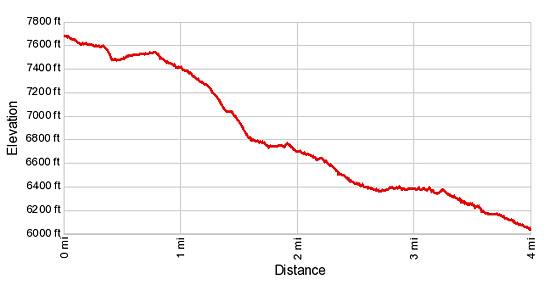
- Elevation: 7,684-ft. - 5,880-ft.
- Elevation Gain: -1,804-ft.
- Difficulty: moderate
- Trail Highlights: See Trail Intro
- Basecamp(s): Saas Fee
- Region: The Valais
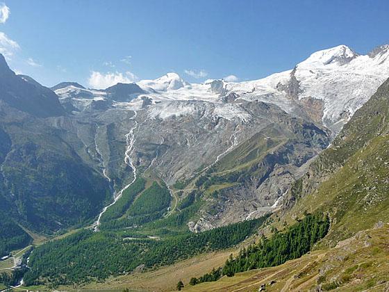
Few trails in the Saas Fee area feature the scenic bang for the miles hiked as the Gemsweg (Chamois Path) from Hannig to Saas Fee. A glacial lake, glistening waterfalls and ever changing views of the high peaks towering above Saas Fee are just a few of the highlights along this delightful trail.
Hannig to Saas Fee (Gemsweg Part 1)
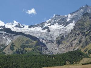
Take the gondola to Hannigalp (7,677-ft.). (See trailhead directions below.) From overlooks near the lift station enjoy wonderful views of the 13,000-ft. (4,000-meter) peaks defining the glacial cirque surrounding Saas Fee. To the south the Fee Glacier clings to the flanks of the Allalinhorn and Alphubel while waterfalls, fed by glacial meltwater, gush down the mountainsides to the valley. The Taschhorn, Dom and Lenzspitze tower above overlook to the southwest while the Fletschhorn, Lagginhorn and Weissmies fill the skyline above the Kreuzboden area to the northeast.
When you are ready to start hiking find the trail signs behind the lift station. Walk southwest in the direction of the Gletschergrotte (1-hr 30-min) and Plattjen (3-hr 20-min). The trail is also referred to as the Gemsweg or Weg von Saas Fee – the Saas Fee trail.
The trail descends on gentle grades, passing above Hannigalp's restaurant and playground. Near the play area you will come to the first of several signs along the trail explaining the history and geology of the Saas Fee area.
At 0.1 miles reach a trail junction. The path to the left (south) drops to Haldenwald and Saas Fee. Continue straight ahead in the direction of the Gletschergrotte and Plattjen, traveling through pretty meadows with splendid views to the glacial cirque towering above Saas Fee.
Follow the trail as it curves to the right (northwest) into a shallow side valley. Here views open the tongue of the Hohbalm Glacier, a hanging glacier spilling down the flanks of a cirque formed by Lenzspitze, the Nadelhorn and the Ulrichshorn.
The trail now drops steeply and crosses a small stream. Beyond the stream the trail climbs gentle slopes heading south/southwest and soon crests a minor ridge at Spissen at 0.7 miles. Here a trail branches right toward the Mischabel Hut. Continue on the main trail that curves right (west) as it drops into a gully and crosses a bridge over a gushing stream carrying meltwater from the Hohbalm Glacier. A use trail, branching to the right after the bridge, climbs steeply toward the Mischabel Hut. Continue along the main trail toward the Gletschergrotte.
The trail now turns south/southeast, descending on moderately-steep grades before climbing slightly to crest a minor ridge at Trift (7,260-ft.) at 1.2 miles. From this vantage point enjoy fine views of the peaks towering above the east side of the Saas Valley including the Fletschhorn, Lagginhorn and Weissmies. Views extend up the length of the Almageller Valley to the Portjenhorn. The Almagellerhorn rises along the south side of the valley.
At Trift a path heads right (west), climbing very steep switchbacks toward the Mischabel Hut. We turn left (east) toward the Gletschergrotte, dropping down a series of short, steep switchbacks that pass some beautiful old larch trees.
Reach a junction at 1.6 miles with a trail that continues descending switchbacks toward Saas Fee. Our trail turns right (southwest) toward the Gletschergrotte, descending on easy grades along a rugged hillside. To the south, glistening waterfalls fed by meltwater from the Fee Glacier cascade down the steep slopes beneath the Allalinhorn and Alphubel.
Cross the temporary bridge over a stream rushing down a cleft in the rocky cliffs above the trail at 1.9 miles. Beyond the crossing enjoy beautiful bird’s-eye views of Saas Fee.
At 2.1 miles the trail turns left (east) and travels through larch trees along the north side of a lateral moraine. Soon the trail swings to the right (south) and climbs to an overlook atop the moraine. Here the Alphubel, Taschhorn and the Fee Glacier form the backdrop for a waterfall, fed by glacial meltwater, cascading down a rugged gorge. Below, a glacial lake lies nestle in a bowl.
The trail now descends along the crest of the moraine for a quarter mile. At 2.6 miles reach an intersection. Here you have a choice. The Weg von Saas Fee turns left (north) and drops down to the open pastures to the south Saas Fee. Broad walkways lead through the pasture back to the main street in Sass Fee at 3.7 miles. Another path heads southeast toward Spielboden and Langfluh (Langflue). I recommend turning right (west) toward the Gletschergrotte and Plattjen.
Follow the trail as it descends along the south face of the moraine wall to the floor of the gorge. Here the trail turns south and cross bridges over braided streams emanating from the waterfall. Beyond the second bridge reach a junction at 2.9 miles. Here you can either return to Saas Fee or continue the hike along the Gemsweg to Plattjen. For more information on Plattjen trail, see the hiking description for Plattjen to Saas Fee.
To return to Saas Fee, travel along the trail as it heads southeast, skirting the right (south) side of the lake at the foot of the glacier gorge. Ignore signs pointing to the Gletschergrotte, Spielboden or Langfluh. Instead walk in the direction of Saas Fee.
Cross a bridge over the lake's outlet stream at 3.1 miles. Past this point the trail descends on moderate grades beside the stream. At 3.25 miles the trail curves to the left (northeast/north) around the base of a hill and heads toward the large open pastures to the south of Saas Fee. Arrive at the pastures at 3.7 miles. Here broad walkways lead northeast toward Saas Fee, reaching the edge of town at 4.0 miles.
For a longer, more challenging hike, combine this hike the reverse of the Plattjen to Saas Fee hike.
Elevation Profile
Driving Directions
To the Hannig Gondola in Saas Fee: This hike starts by taking the Hannig Gondola to Hannigalp. From the Saas Fee Bus Terminal at the Post Platz, head west/northwest on Obere Dorfstrasse to a “T” intersection. Turn right on Bielmattstrasse. Follow Bielmattstrasse for one block and turn left on Bielmattweg. (The Hotel Garni Domino Gabriel Bumann is at the corner.) Follow Bielmattweg to the “T” intersection and take a right on Hannigstrasse. Walk a little over 100-ft. up the street to the Hannig gondola station. There are trail signs along the route directing you to the lift.
Trail Resources
Trail Intro / Trail Photo Gallery / Trail Map
Basecamp(s) Information:
Saas Fee
Region Information:
The Valais
Other Hiking Regions in:
Switzerland