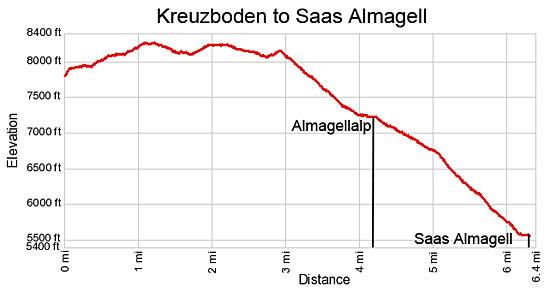
Details: Kreuzboden to Saas Almagell (Hohenweg Kreuzboden) 
Distance: 6.0 - 6.3 miles (one way)
near Saas Fee in The Valais
Hike Facts
- Distance: 6.0 - 6.3 miles (one way)
- Elevation: 7,872-ft. - 8,302-ft.
- Elevation Gain: 430-ft.
- Difficulty: moderate
- Trail Highlights: See Trail Intro
- Basecamp(s): Saas Fee
- Region: The Valais
This scenic walk, with panoramic views of the Mischabel Range, traverses high above the east side of the Saas Valley before entering the beautiful Almageller Valley. End the hike by descending to Saas Almagell or take the challenging Adventure Trail to Furggstalden.
Kreuzboden to Saas Almagell or Furggstalden

Take the bus to Saas Grund and then ride the gondola to Kreuzboden (7,874-ft.). (See trailhead directions below.) Outside the lift station trail signs point east to a gravel road heading for Almagelleralp (2-hr 45-min) and Saas Almagell (3-hr 45-min). The road/trail to Almagelleralp coincides with the first section of the Alpenblumen-Promenade (Alpine Flower Trail), with signs along the path identifying some of the 240 species of wildflowers found in the area.
The gravel path curves around the back of the gondola station and quickly turns into a dirt trail heading south/southeast. Soon the trail crosses a wood bridge over a stream fed by meltwater from the Trift Glacier. Beyond the bridge the path ascends on easy to moderate grades through pretty meadows sprinkled with wildflowers along the Weissmies west facing slopes.
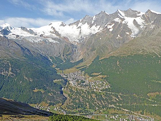
To the west/southwest, across the Saastal (Saas Valley), enjoy wonderful views of the 13,000-ft. (4,000-meter) peaks of the Mischabel Range including the Allalinhorn, Alphubel, Taschhorn, Dom and Lenzspitze. The massive Fee Glacier glaciers cling to the flanks of the peaks between the Allalinhorn and Lenzspitze while waterfalls, fed by glacial meltwater, gush down the mountainsides. To the west then Hohbalm and Bider Glaciers spill down the slopes between Lenzspitze and Balfrin. In the distance to the north are views of the Bernese Alps.
At 0.6 miles the trail crosses a wood/metal bridge over a small stream. Soon the meadows give way to a rocky landscape strewn with large boulders. At 1.0 mile the trail curves to the west and starts climbing through rockslides. As you ascend the rugged landscape views open behind you to the Lagginhorn and the Fletschhorn rising above Kreuzboden.
Soon the grade abates and the trail descends gently as it curves to the south around the end of a ridge extending west from the Trifthorn. From this vantage point enjoy wonderful views of the 13,000-ft. summits defining the glacial cirque surrounding Saas Fee. In the distance to the south views open to the Mattmark Dam and the peaks rimming the head of the Saastal.
Beyond the viewpoint the trail descends on moderate grades along a steep hillside, threading its way through snow fencing installed to control avalanches. Metal and rope fencing offers a level of security along a steep, narrow section of the trail with some exposure. This section of the trail should not present any problems unless it is covered with ice or slick snow.
Reach a dirt road and trail junction at 1.7 miles. The road descending on switchbacks down the hillside to the right (west) leads to Furrwald and Saas Grund on the valley floor. We continue straight ahead (south) on the dirt road heading toward Almagelleralp (1-hr 50-min) and Saas Almagell (2-hr 50-min). The road now ascends on easy to moderate grades along the west facing slopes of the Trifthorn, accompanied by excellent views of Saas Fee and the Mischabel Range.
At 2.0 miles the grade abates and the road reverts to a trail that descends south across the hillside on gentle grades. Go through a metal gate at 2.4 miles and then follow the trail as it crosses a few landslides. To the south enjoy ever improving views of the Mattmark area at the head of the Saas Valley.
At 2.7 miles the path briefly climbs to avoid an old landslide and then continues descending as it curves to the southeast into the Almagellertal (Almageller Valley). Here views open to the Portjenhorn and Pizzo d'Andolla towering above the ridge at the head of the valley. The rugged Almagellerhorn looms above the south side of the Almageller Valley.
The trail now descends on moderately steep grades through rocky meadows along the north side of the valley. Near the valley floor the path travels by a few beautiful old larch trees. At a junction at 3.8 miles continue toward Almagelleralp. The trail will actually pass above the Almagelleralp’s three story stone structure and then drop down to the valley floor at 4.2 miles. Here signs point east toward Zwischbergen Pass and the Almagell Hut. To find a nice place for a picnic turn left (east) and walk a short distance up the valley to a spot with good views. Along the way pass Almagelleralp where you will find a small restaurant.
When you are ready to continue the hike, follow the trail heading down valley (west) on moderate grades through boulder strewn pastures along the right (north) side of the Leebach, the stream draining the Almageller Valley. Reach a junction at 5.0 miles and turn left (south) toward Furggstalden and Saas Almagell on a trail that crosses a wood bridge over the stream.
Travel through a larch forest for 0.1 miles to a second junction. Here you have two options. The trail branching to the right (southwest) drops down steep switchbacks to Saas Almagell. The path continuing straight ahead (south) toward Furggstalden travels along an “Adventure Trail,” a challenging route with a ~200-ft. (60-meter) long swing bridge. At Furggstalden a chairlift and a trail descend to Saas Almagell.
The Adventure Trail is not recommended for small children or anyone with a fear of heights. Sections of the trail travel along narrow boards attached to steep slopes, climb down metal steps bolted to a cliff face and cross rockslides. This trail is definitely not for the faint of heart. (The online photo gallery includes pictures of trail.) If you are not tired and up for the challenge then take the Adventure Trail and have a great time.
If you have any doubts about the Adventure Trail, turn right at the junction on the path towards Saas Almagell. This trail descends step switchbacks through a larch forest, reaching the Saas Almagell Post bus stop at 6.3 miles. The “Adventure Trail” arrives at Furggstalden at 6.0 miles. At Furggstalden take the chairlift down the Saas Almagell and then walk to the post bus stop. Signs point the way.
Elevation Profile
Driving Directions
From the Saas Fee Bus Terminal to Kreuzboden: At the Saas Fee bus terminal, purchase a ticket for Saas Grund Bergbahnen. Get on a bus bound for Brig and get off at the Saas Grund Bergbahnen stop. The ride takes 10 minutes. From the bus stop walk east to the bottom of the Kreuzboden Gondola Station and purchase a one-way ticket to Kreuzboden. See the Kreuzboden Gondola site for schedules and fares.
To Return to Saas Fee from Saas Almagell: Get on a bus bound for either Saas Fee or Saas Grund. If you are on a Saas Grund bus, change at Saas Grund for a bus going to Saas Free. (During busy times in the summer you may not need to change buses – always check the front of the bus to see its ultimate destination.)
To Return to Saas Fee from Furggstalden: Take the Furggstalden chair lift down to Saas Almagell and then follow the signs to the postbus stop. Get on a bus bound for either Saas Fee or Saas Grund. If you are on a Saas Grund bus, change at Saas Grund for a bus going to Saas Free. (During busy times in the summer you may not need to change buses – always check the front of the bus to see its ultimate destination.) For more information on the lifts see the Saas Fee Lift Schedule and look at the section labeled Saas-Almagell.
Trail Resources
Trail Intro / Trail Photo Gallery / Trail Map
Basecamp(s) Information:
Saas Fee
Region Information:
The Valais
Other Hiking Regions in:
Switzerland