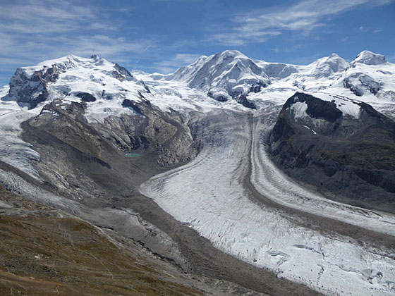
Monte Rosa, Lyskamm, Castor and Pollux from the Gornergrat viewpoint
Great views accompany almost every step of this hike leading to Gornergrat, a glorious overlook with panoramic views of 20 peaks over 13,000-ft. (4,000-meters) high.
See Trail Detail/Full Description
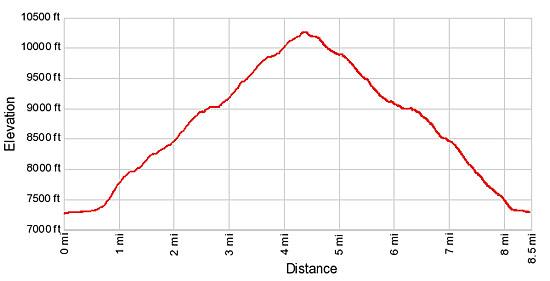
- Distance: 4.4 miles (one way) to Gornergrat
8.5 miles (loop) to Riffelalp from Gornergrat (Complete Loop) - Elevation: 7,134-ft. at Trailhead
10,138-ft. at Gornergrat
7,134-ft. at Riffelalp from Gornergrat (Complete Loop) - Elevation Gain: 3,004-ft. to Gornergrat
-3,004-ft. to Riffelalp from Gornergrat (Complete Loop) - Difficulty: moderate-strenuous
- More Hikes in:
Zermatt / The Valais
Why Hike Gornergrat Loop
Gornergrat is one of the finest overlooks in Zermatt with glorious, panoramic views of 20 peaks over 13,000-ft. (4,000-meters) high. A network of scenic hiking trails climbs the Riffelalp plateau and the Gornergrat ridge to the viewpoint. This loop hikes combines a short ride on the Gornergrat Cog railway with, in my opinion, the most scenic trails to create an unforgettable hike that will have you constantly reaching for your camera.
The hike, starting in Riffelalp, ascends the steep slopes below the Riffelberg plateau accompanied by great views of the iconic Matterhorn towering above the head of the Zermatt Valley. To the northwest a massive wall of 4,000-meter peaks, including Dent Blanche, the Ober Gabelhorn massif, the Zinalrothorn and the Weisshorn, fill the skyline. The Taschhorn and the Dom form a backdrop for the Oberrothorn to the northeast.
As the trail crests and then curves around the south side of the Riffelberg plateau views open to Monte Rosa, Liskamm, Castor, Pollux and the Breithorn massifs, clad in glistening glaciers. Soon the path passes the Riffelsee with more great views of the Matterhorn reflected in its mirror-like surface. Beyond the Riffelsee the trail climbs steeply up the ridge to the summit of Gornergrat, where you'll find a railway station, hotel and restaurants.
The lookout above the complex offers superb 360-degree vistas of the high peaks and glaciers showcased on the ascent from Riffelalp. Below the viewpoint are breathtaking, bird’s-eye views of the Gorner Glacier, the second largest glacier system in the Alps. Tributary glaciers flowing down the slopes of Monte Rosa and nearby peaks join this massive river of ice flowing west from the Monte Rosa massif. Signs at the viewpoint help you to identify the summits and glaciers.
The return journey from Gornergrat drops down the ridge and then crosses the Riffelberg plateau, with more wonderful views of the peaks to the north and west. A scenic trail, with wide-ranging views of the valley, descends steeply from Riffelberg to Riffelalp where hikers jump on a return train to Zermatt.
The hike can be shortened by riding the cog railway all the way to Gornergrat and walking down or by taking the train to Riffelberg or Rotenboden, which reduce the distance and elevation gain required to reach Gornergrat. Energetic parties may opt to walk all the way back to Zermatt along pleasant, forested tracks dropping down steep switchbacks to Winkelmatten, a neighborhood at the south end of Zermatt.
It is best to get an early start on the hike. In the afternoon the Gornergrat viewpoint can get quite windy and the peaks are more likely to be obscured in clouds.
Elevation Profile
| Support our Site |
Trail Resources
Trail Detail/Full Description / Trail Photo Gallery / Trail Map
Basecamp(s) Information:
Zermatt
Region Information:
The Valais
Other Hiking Regions in:
Switzerland