Hike Facts
- Distance: 5.8 miles (loop)
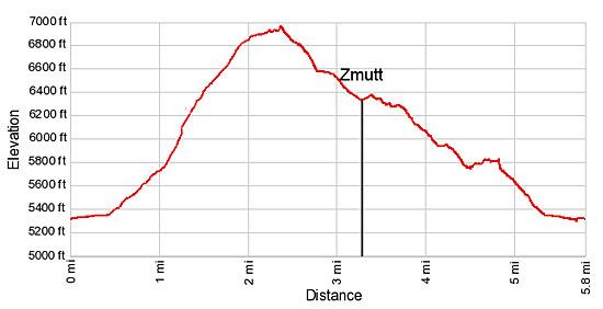
- Elevation: 5,295-ft. - 6,970-ft.
- Elevation Gain: 1,675-ft.
- Difficulty: easy-moderate
- Trail Highlights: See Trail Intro
- Basecamp(s): Zermatt
- Region: The Valais
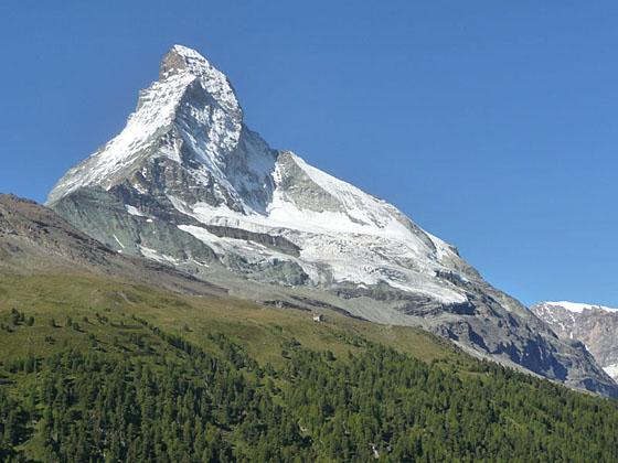
Pretty meadows, larch forests and nice views of the Matterhorn make this trail a good option for families and hikers looking for a pleasant half day walk.
Zmutt Loop Hike
This description of the Zmutt Loop trail assumes hikers walk in a counter-clockwise direction taking the high path to Zmutt and returning via the low or mid-level path. From the Bahnhof (train station) in Zermatt, walk south on Bahnhofstrasse (the main street) for 0.4 miles. After passing the Matterhorn Museum and a church (both on your left) the road soon curves to the right. The first street to the right after the curve is Schalpmattgasse. Bear right (west) onto Schalpmattgasse toward Hubel, Alterhaupt and Chalbermatten. Ignore the other signs at the intersection pointing straight ahead (south) to Zmutt. This is the low route that can be used on the return leg. (See trailhead directions below.)
Walk up Schalpmattgasse for 0.1 miles and turn right (north) on the alleyway signed for Hubel and Zmutt. The turn is between an old wood granary (on a cement base) and the Chalet Talina. Soon the paved road curves to the left and turns into a trail, ascending steep switchbacks through pastures.
Reach a junction at 0.8 miles and turn left (south/southwest) in the direction of Hubel and Zmutt. The path now climbs the grassy hillside, passing through a small grove of larch trees, to Herbrigg (5,758-ft.) at 1.0 mile. The small hamlet, with its traditional Walser-style wood homes, barns and granaries, enjoys nice views of the high peaks of the Mischabel Range to the northeast along with bird’s-eye views of Zermatt. The summit of the Matterhorn peeks above the hillside to the southwest.
At the junction in the middle of Herbrigg, take the trail branching right (west) toward Hubel and Zmutt. The trail bearing left will be our return route via the mid-level path. Beyond Herbrigg the track ascends steep grassy slopes sprinkled with wildflowers and larches. As you climb, the Breithorn and the Klein Matterhorn, a distinctively shaped knob, appear above the hillside across the valley.
Pass a group of old stone buildings at 1.3 miles and then reach Hubel (6,385-ft.), a scattered collection of old wood and stone structures, at 1.5 miles. Here a signed trail heads right (north), climbing toward Alterhaupt and Trift. We continue straight ahead to Zmutt.
The trail now ascends on moderate grades along a beautiful meadow-clad bench beneath the steep walls of the Hohbalm plateau. The distinctively-shaped Matterhorn, partially hidden by the steep slopes, rises to the southwest. Nice views extend east up the Findel Valley toward the Strahlhorn and Rimpfishhorn. Nearer at hand, small shrubs, wildflowers and scattered larches add interest to the walk.
At 1.7 miles reach a “Y” intersection. Here a trail branching left (south) descends to Zmutt in 0.75 miles. This is the traditional high route to Zmutt. If time and energy permit, I suggest taking the trail branching to the right, the continuation of the walk along the high bench. This option adds 0.9 miles and 370-ft. in elevation gain to the hike but the extra effort is well rewarded with great views.
To extend the walk, continue ascending along the bench. As you climb enjoy ever improving views of the Matterhorn, the Findel Glacier area (to the east), the Breithorn and Klein Matterhorn (to the southeast) and the Mischabel Range (behind you).
At 2.1 miles the trail curves to the west revealing the peaks and glaciers at the head of the Zmutt Valley. The full extent of the Matterhorn’s east and north face, along with the Matterhorn glacier, are now in view.
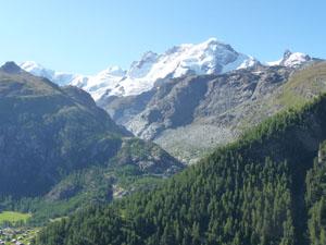
Reach the high point of the hike (6,970-ft.) at 2.2 miles. Here hikers have a bird’s-eye view of Zmutt, 600-ft. below. Across the valley the majestic Matterhorn dominates the view. To the southeast Monte Rosa, Lyskamm and the Breithorn rise above the Gorner Valley. The Strahlhorn, Rimpfishhorn and Findel Glacier fill the horizon to the east. Above the trail steep meadows lead to the towering south wall of the Hohbalm plateau.
The meadows around the high point are a great place to take a break and enjoy the terrific views. When you finally pull yourself away, follow the trail as it descends from the bench on moderate grades toward the Zmutt Dam. The arch dam, finished in 1964, stores water from the Zmutt Glacier and is part of the Grande Dixence hydroelectric project.
Arrive at the signed junction below the dam at 2.75 miles and turn left (southeast) toward Zmutt on a pleasant trail traveling through pastures on moderate to easy grades. At 3.0 miles turn right (south) on a trail dropping steeply down to the tiny hamlet of Zmutt (6,350-ft.) at 3.1 miles. The path now passes through a cluster of restaurants, typically packed with people, and turns left (southeast) toward Zermatt.
Beyond Zmutt a broad track, popular with tourists, returns to Zermatt via the Zmutt low route (see directions below) in 2.4 miles. Hikers looking for more solitude on the return journey can take a slightly longer trail (2.7 miles) that travels above the main track on a “mid-level” route.
To reach the mid-level route back to Zermatt follow the broad track down from Zmutt for 0.2 miles (3.3 miles from the start) to a signed junction amid a few buildings. Here signs point straight ahead toward Zum See, Blatten and Zermatt. We turn left (north) on an alternate route also signed for Zermatt.
Follow the trail along the east side of a building to a “Y” intersection. Take the trail branching to the right (northeast). Walk a very short distance on the trail to a second “Y” intersection. The trail to the left climbs to Hubel and the high route. Our trail branches right (east) toward Zermatt Kirche (Church) and the Zermatt Bahnhof.
Initially the trail travels through meadows and a small cluster of houses with nice views of the Oberrothorn, Strahlhorn and Rimpfishhorn. Not far beyond the houses the trail enters the trees and at 3.8 miles starts descending steeply along a forested hillside. At 4.3 miles the trees give way to steep meadows with views of the Oberrothorn and the high peaks of the Mischabel range.
The descent ends at 4.5 miles. The trail now climbs a short distance on moderate grades before crossing a grassy bowl to Herbrigg at 4.8 miles. From Herbrigg, retrace your steps back to Zermatt. Remember to turn right at 5.0 miles where signs point downhill toward Zermatt.
Reach Schalpmattgasse at 5.2 miles and turn left (east), walking a short distance to Oberdorfstrasse where you turn left (northeast) again. The street soon passes the church, where the street name changes to Bahnhofstrasse, and then heads to the train station at 5.8 miles.
Elevation Profile
Driving Directions
From the Zermatt Bahnhof (Train Station):Walk south on Bahnhofstrasse, the town’s main street, for 0.4 miles. Pass the Matterhorn Museum and the Pfarrkirche St. Mauritius (church) on the left. Just beyond the church the road curves to the right. The first road/walkway to the right is Schalpmattgasse. (Look for a blue street sign on the Chalet Adlerhost.) Signs at the corner point right (west) toward Hubel, Alterhaupt and Chalbermatten. This is the high route. Signs pointing straight ahead (south) to Zmutt direct you to the low route. (Note: At the church the street name changes from Bahnhofstrasse to Oberdorfstrasse.)
Low Route - From the Zermatt Bahnhof (Train Station): Walk south on Bahnhofstrasse, the town’s main street. As you walk down the main street you will pass the Matterhorn Museum and the Pfarrkirche St. Mauritius (church) on the left. Soon the road curves to the right and its name changes to Oberdorfstrasse. Along the way signs point straight ahead to Zmutt.
After walking 0.75 miles, reach a large paved area with a taxi stand and bus stop where the walkway splits. Take the broad track branching right, signed for Zmuttweg and Edelweissweg. Hiking signs point to Zmutt and Schonbielhutte. The broad walkway now climbs through meadows and forested hillsides along the right (northwest) side of the Zmuttbach (Zmutt River). Signs along the way direct you to Zmutt. Reach the small hamlet in about an hour and 10 minutes after walking 2.4 miles and gaining 1,055-ft. (If you are not acclimated the walk will take longer.)
Trail Resources
Trail Intro / Trail Photo Gallery / Trail Map
Basecamp(s) Information:
Zermatt
Region Information:
The Valais
Other Hiking Regions in:
Switzerland