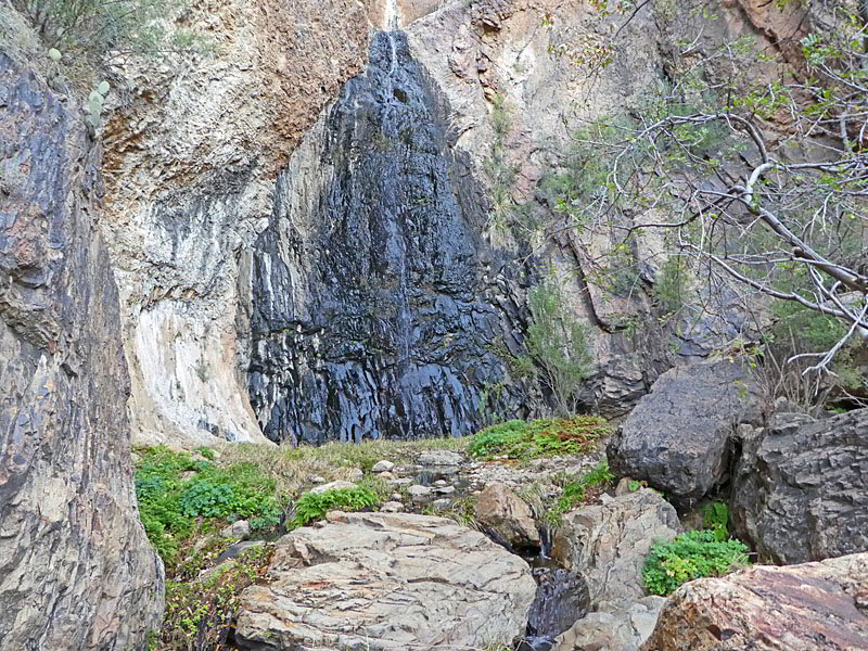
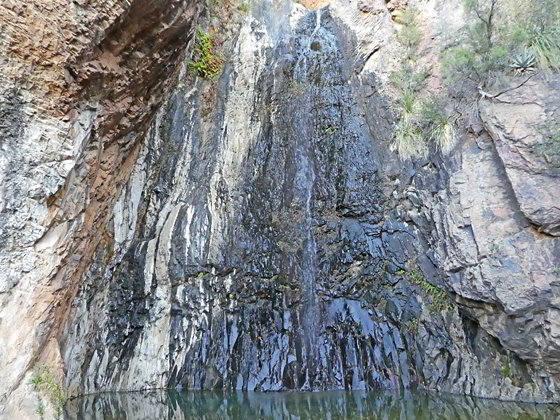
This hidden oasis in the desert is truly a special place. Here a spring fed waterfall trickles down an 80-ft. pour-off into a pool. The micro-ecosystem around the fall is a haven for wildlife and plants not typically seen in the desert. Some scrambling over boulders is required to reach the falls.
- Distance: 3.2 - 5.8 miles (RT)
- Elevation: 3,646-ft. at Trailhead
Maximum elevation - 4,150-ft. - Elevation Gain: 504-ft.
- Difficulty: moderate
- Basecamp: Big Bend
- Region: Texas Parks
Trail Description - Cattail Falls

Cattail Canyon, considered to be the most rugged canyon in Texas, starts near Laguna Meadows in the Chisos Mountains and flows north along the west side of the range, dropping 2,500-ft. as it cut a dramatic gorge with significant pour-offs. On the south side of Carter Peak the canyon spills down its final pour-off along the west side of the range, dropping about 80-ft. into a pool nestled in a secluded basin in the Chihuahuan Desert.
A year-round spring near the top of the pour-off typically keeps a trickle of water spilling over the ledge, creating a lovely oasis in the desert. During wet periods the trickle turns into a beautiful falls. The cool, moist area around the oasis is a haven for wildlife and supports a variety of ferns, palms, agaves and flowering plants, such as columbines and cardinal flowers, in season. A small creek emanating from the falls flows through a series of pools, watering Oak trees in the wash below the basin.
The Cattail Falls trail visits this special place. You will not find the trail on any park brochures or maps. Please treat this area with respect. Don’t wade in the pools. Try to walk on the rocks as opposed to the soil so as not to damage this delicate, fragile environment.
The Cattail Falls trail, which is about one mile long, branches off of the Oak Springs Trail and then heads south to Cattail Canyon before turning east and ascending along the north side of Cattail Canyon to the secluded oasis and falls. The hike to the falls can easily be combined with a hike to Oak Spring Canyon. See the Oak Springs trail description for information on this segment of the hike.
Note: This trail has two possible starting points. A 1.3 miles gravel road leads from the Ross Maxwell Scenic Drive to the trailhead parking area. If the road is open and in good condition, hikers can start from this point. Otherwise, park along the Ross Maxwell Scenic Drive and walk up the trailhead access road, adding 1.3 miles (one-way) to the hike.
In the description below, two mileage numbers are provided in the description. The first is the mileage from the trailhead parking area and the second is the mileage from the Ross Maxwell Scenic Drive.
Starting From Ross Maxwell Scenic Drive
Distance: 5.8 miles (round-trip) Elevation Gain: 664-ft.
The access road to the trailhead for this hike starts along the Ross Maxwell Scenic Drive just to the north of the Sam Nail Ranch. (See the driving directions below for more information.) From the Ross Maxwell Drive the gravel access road ascends on gentle grades through the Chihuahuan Desert accompanied by good views of the Chisos Mountains towering above the desert to the east while the Christmas Mountains rise to the north. Behind you Burro Mesa dominates the skyline. The access road reaches the trailhead parking area in 1.3 miles.
Starting from the Trailhead Parking Area
Distance: 3.2 miles (round-trip) Elevation Gain: 467-ft.
The access road to the trailhead for this hike starts along the Ross Maxwell Scenic Drive just to the north of the Sam Nail Ranch. (See the driving directions below for more information.) Just beyond the trailhead parking lot signs point up the road toward the Window Trail via Oak Spring, Oak Spring and the Cattail Fall Trails. Past the parking area the trail quickly reaches a gate. Go around the gate and then ascend the road on easy to moderately easy grades through typical Chihuahuan Desert terrain.
Ahead are fine views of the Chisos Mountains and the Window, located in the V-shaped saddle between Vernon Bailey Peak (the rounded peak) and Carter Peak (the triangular peak). The Christmas Mountains are seen in the distance to the northwest.
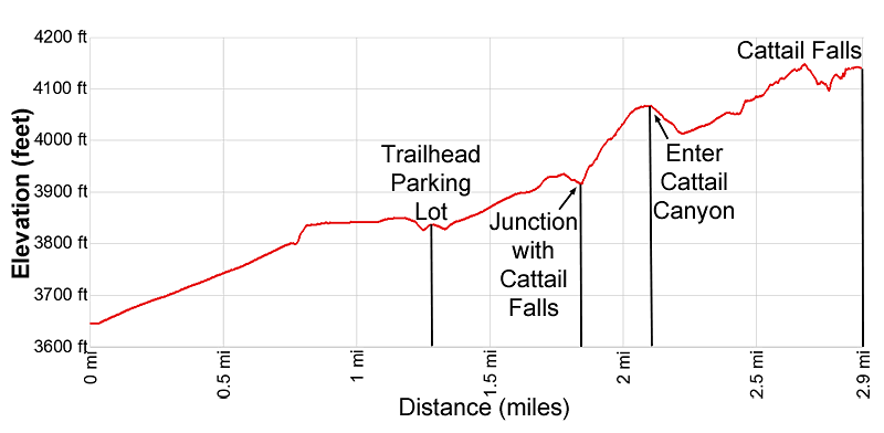
At 0.5/1.8 miles the trail descends into the Oak Creek drainage, clad in trees and shrubs. A short distance beyond a large Oak tree and a sign mark the junction with the trail to Cattail Falls, branching right. The Oak Creek trail continues up the road.
We bear right (south) on the Cattail Falls trail. The trail soon begins ascending log stairs on moderate grades, climbing over the low ridge between Oak Spring and Cattail Canyons, accompanied by fine views of Vernon Bailey and Carter Peaks. After 0.2 miles the grade abates and the path now traverses across the broad ridge.
At 0.8/2.1 miles the path descends into Cattail Canyon where it curves to the left (southeast). Here views open to a saddle to the south of Carter Peak. Our destination is at the base of this saddle. The path now ascends on easy to moderately-easy grades towards the basin beneath the saddle.

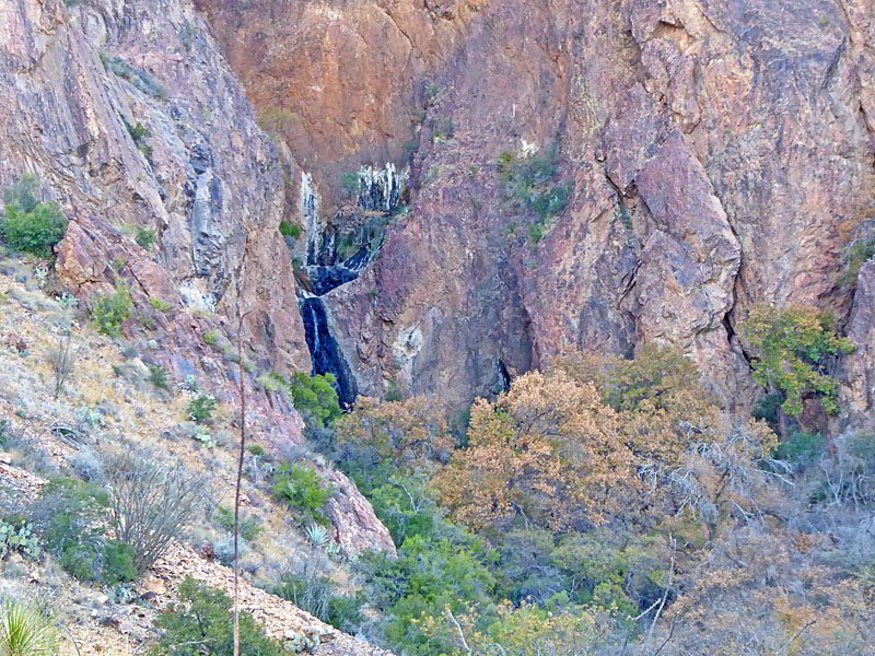
Reach the rim along the north side of the Cattail Canyon wash at 0.95/2.25 miles. The trail now ascends along or near the rim of the wash on easy grades. At 1.4/2.7 miles the trail curves to the right and drops down to the floor of the wash. As you descend you will see Cattail Falls spilling down a pour-off. The path now heads up the north side of the wash through a healthy cluster of Oak trees. Rugged crags rise above the trail.
The wash now constricts and is clogged with lush vegetation and trees, making progress a little more challenging. As you proceed you will start seeing beautiful pool set amid rock slabs, boulders and vegetation. A small stream connects the pools.
Soon you will need to scramble over some boulders and rock slabs and rock-hop across small pools to get to the source of the stream, a pool at the base of Cattail Falls at 1.6/2.9 miles.
The 80-ft., spring fed waterfall flows over a pour-off and down a sheer wall into the pool. The moist area around the falls creates an enchanting oasis harboring several varieties of ferns, palms agaves and flowering plants, such as columbines and cardinal flower, in season. There is also poison oak – so be careful what you touch.
Please keep in mind that this is a very fragile area. When exploring the basin stay on the rocks and avoid trampling the soil and vegetation. Don’t wade in the pools. Remember this is a source of water for the area’s wildlife.
After enjoying this lovely oasis return to the junction with the Oak Springs trail and either hike further up Oak Springs or return to your vehicle. See the Oak Springs trail for more information.
Elevation Profile

Driving Directions
From the Big Bend National Park Headquarters at Panther Junction: From Panther Junction, at the intersection of the Persimmon Gap Road and the West Entrance Road, head west on the West Entrance (Gano Springs) road toward Basin Junction. Follow the road for 12.7 miles and then turn left on the Ross Maxwell Scenic Drive. Drive 3.3 miles on the Ross Maxwell road and turn left (east) onto the unmarked Oak Spring Road. (If you come to the pull-out for the Sam Nail Ranch you missed your turn.) Follow the gravel Oak Spring Road for 1.3 miles to the trailhead parking area on the north side of the road.
The road is typically OK for passenger cars. Check at the ranger station for road conditions and to determine if the road is open. If you need to walk from Ross Maxwell Drive to the trailhead add 1.3 mile (one-way) to the distances in the trail description.
From the Chisos Mountain Lodge area: Head northeast on Chisos Basin Road for 6.4 miles and then turn left onto the West Entrance Road. Follow the West Entrance Road for 9.5 miles and the turn left onto the Ross Maxwell Scenic Drive. Drive 3.3 miles on the Ross Maxwell road and turn left (east) onto the unmarked Oak Spring Road. (If you come to the pull-out for the Sam Nail Ranch you missed your turn.) Follow the gravel Oak Spring Road for 1.3 miles to the trailhead parking area on the north side of the road.
The road is typically OK for passenger cars. Check at the ranger station for road conditions and to determine if the road is open. If you need to walk from Ross Maxwell Drive to the trailhead at 1.3 mile (one-way) to the distances in the trail description.
Trail Resources
- Trail Photo Gallery
- Trail Maps
- Basecamp(s) Information: Big Bend
- Region Information: Texas Parks
- Other Hiking Regions in: Texas
