Details: Peek-a-boo Loop 
Distance: 5.0 miles (loop)
Bryce Canyon National Park, near Bryce in South Central Utah
Hike Facts
- Distance: 5.0 miles (loop)
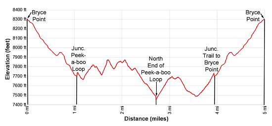
- Elevation: 8,300-ft. - 7,440-ft.
- Elevation Gain: -860-ft.
- Difficulty: moderate-strenuous
- Trail Highlights: See Trail Intro
- Basecamp(s): Bryce
- Region: South Central Utah
The Wall of Windows, the Cathedral and Fairy Castle along with terrific views of the Bryce Amphitheater and rock formation along Peek-a-boo Canyon are the rewards for completing this scenic loop trail. A steep descent and ascent from Bryce Point are required to reach to the loop.
Peek-a-boo Loop Description
There are three ways to access the Peek-a-boo Loop; Bryce Point, Sunset Point and Sunrise Point. The Bryce Point option, following the Under the Rim trail to the north end of the Peek-a-boo Loop, is described below. The other two options, from Sunset and Sunrise Points, are covered in the Figure 8 Loop hiking description.
The trail from Bryce Point to the Peek-a-boo Loop starts at the north end of the Bryce Point Parking area and loses over 600-ft in just over a mile. (See driving directions below.) From the trailhead the path descends south through trees below the east side of the parking area to a junction with the Under the Rim trail at 0.1 miles. At the junction turn left (northeast) toward the Peek-a-boo Loop. The trail to the right heads southeast toward the Hat Shop rock formation.
The path soon curves to the east and the trees thin as the trail drops down a series of switchbacks with fine views of Bryce Canyon and Bristlecone Point to the northeast. Some very old bristlecone pine trees grow along the switchbacks. At 0.4 miles the trail turns sharply left (northwest) on a descending traverse beneath the limestone cliffs jutting from the rim.
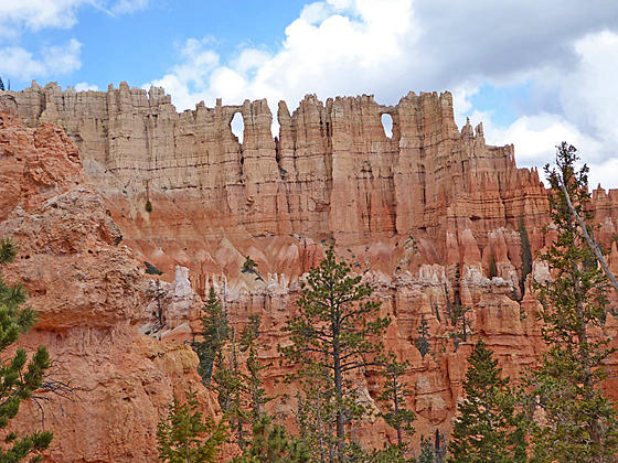
At 0.5 miles travel through a tunnel chisel through a fin. Beyond the tunnel the grade abates as the trail crosses a broad ridge. This area is prone to rock slides so the trail maybe rocky and narrow in spots. At 0.75 miles the trail passes beneath Bryce Point and soon starts descending switchback down the east side of Peek-a-boo Canyon. As you descend enjoy great views of the rock formation along the canyon walls. The Wall of Windows, a thin fin eroded into hoodoos with windows of various sizes, is seen across the canyon to the west. Below the trail trees grow along the wash winding down the canyon floor.
A little over a mile from the start the trail reaches the junction with the Peek-a-boo Loop trail. Here we turn left (south), traveling around the loop in the clockwise direction. At 1.1 miles pass a horse corral and watering trough. You will also find pit toilets in this area.
Past the corral the trail turns right (west/northwest) and curves around the head of the canyon through a corrugated landscape of minor ridges and gullies. Eroded rock formations along the rim tower overhead. Closer at hand are the formations lining the gullies carrying meltwater from the rim. At 1.4 miles the trail passes directly beneath the Wall of Windows, a massive fin topping the ridge rimming the canyon’s western wall.
At 1.6 miles the trail turns left (north) and climbs through a maze of formations, passing through a tunnel on its way to the top of a ridge. The path now travels high above the west side of Peek-a-boo Canyon, crossing a minor ridge before ascending to and crossing the ridge separating Peek-a-boo and Bryce Canyons at 2.1 miles. Here wonderful views open to the formations along the rim to the southeast of Inspiration Point. The Cathedral, an aptly named formation, towers above the trail to the right (east).
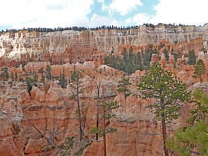
The path now descends along the east side of Bruce Canyon with fine views of Silent City to the north. Soon the trail curves to the northeast, dropping down switchbacks to a junction and the low point (7,440-ft.) of the Peek-a-boo Loop at 2.7 miles. To the left is the trail leading toward the Horse Trail and the Navajo Trail climbing to Sunset Point. We turn right (south) on the continuation of the Peek-a-boo Loop.
The path now ascends steeply up a ridge separating Bryce and Peek-a-boo canyons. Along the way the trail climbs by interesting rock formations and enjoys fine views of Boat Mesa and the hoodoos along the rim. Near the top of the ridge views open to the Fairy Castle Rock formation.
As you crest the ridge the trail passes by a large standalone hoodoo and terrific views open to a sea of hoodoos, pinnacles and fins beneath Bryce point and along Peek-a-boo Canyon. The trail now zig-zags down the ridge, travels through a tunnel at 3.2 miles and then crosses Peek-a-boo Canyon’s wash at 3.5 miles. Beyond the wash the path climbs along the east side of Peek-a-boo Canyon. As you ascend great views open to the Wall of Windows and a labyrinth of rock formation at the head of the canyon.
At 3.9 miles reach the junction with the connector trail returning to Bryce Point. Turn left and retrace your steps to Bryce Point at 5.0 miles.
There are few flat spots along the trail. You will constantly be ascending and descending, crossing minor ridges and canyons as you travel around the loop. The hike is exposed to the sun and can get quite toasty during the summer. Be sure to carry plenty of water and get an early start to beat the heat of the day.
This trail is shared by horses. If you run into horses, get well off the trail and let them pass.
Elevation Profile
Driving Directions
From the Bryce Canyon Visitor Center to Bryce Point: From the Visitor Center, located along UT 63, head south on UT 63 for 1.6 miles and then turn left onto Bryce Point Road. Follow Bryce Point Road for 1.9 miles and park in the lot at the end of the road.
Alternatively, take the Park Shuttle Bus to the Bryce Point stop (stop 3). The buses run every 10-15 minutes from April to October. The shuttle bus parking lot is located along UT 63, a short distance past Ruby’s Inn (in the hotel area). Limited parking is also available at the Bryce Visitor Center (stop 1), located 2.4 miles from the parking area.
Trail Resources
Trail Intro / Trail Photo Gallery / Trail Map
Basecamp(s) Information:
Bryce
Region Information:
South Central Utah
Other Hiking Regions in:
Utah