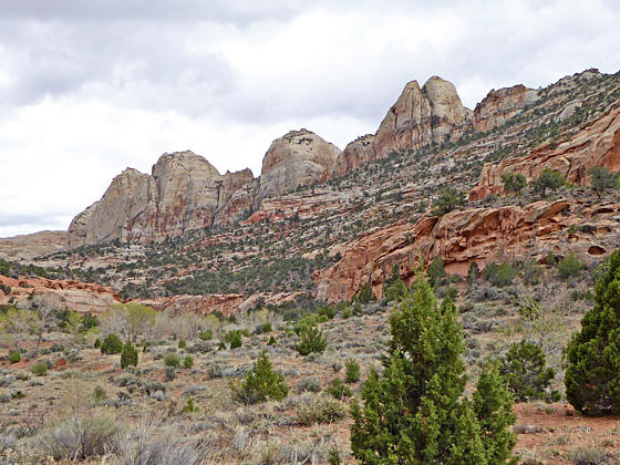
Pleasant Creek 
Distance: 1.5 - 7.4 miles
Fruita District, Capitol Reef National Park, near Capitol Reef in South Central Utah
By: Diane Greer
Pleasant Creek
Pleasant Creek Canyon, carved over millenniums by a lovely perennial stream, is a great place to explore. With no maintained trails, hikers follow routes leading up and down the canyon, along the way discovering rock art, narrows in side canyons and interesting formations.
- Distance: 1.5 - 7.4 miles (RT)
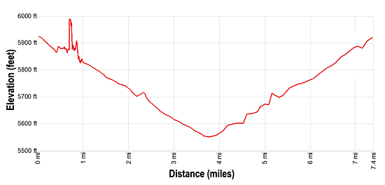
- Elevation: 5,920-ft. at Trailhead
Maximum elevation - 5,550-ft. - Elevation Gain: -370-ft.
- Difficulty: moderate
- Basecamp: Capitol Reef
- Region: South Central Utah
Trail Description - Pleasant Creek
Perennial stream in the desert are very special, supporting habitats that sustain humans and wildlife over the centuries. Pleasant Creek is no exception. Over time the beautiful stream cut a deep, scenic canyon through the heart of Capitol Reef. Here native people of the Fremont culture left behind rock art panels dating back 7,000 year to the Archaic Period. Later, during the late 1800’s and early 1900’s, settlers carved their names and inscriptions on the canyon’s cliffs and large boulders.
A hike up or down the canyon offers opportunities to explore this special place and discover evidence of its prior inhabitants. While there are no official trails, boot beaten footpaths will help keep you on track. Please be sure to remain on the paths and not trod on the biological soil crusts, which help prevent erosion.
The canyon offers options for parties looking for a short day hike and hikers seeking to spend all day exploring the length of the canyon within the park boundaries. Note that longer hikes require numerous stream crossings that will require getting your feet wet. Carrying a map is advisable for anyone venturing up or down the canyon.
While it is possible to explore both up and down stream, I recommend that hikers start by heading east, downstream. In my opinion this is the most interesting and beautiful section of the canyon offering more options for exploration.
Lower Pleasant Creek toward east park boundary
- Distance: 1.5 – 7.4 miles RT
- Elevation: 5,920-ft. – 5,990-ft. – 5,550-ft.
- Elevation Gain/Loss:+70-ft. / -440-ft.
From the parking area (see driving directions below) walk east and cross the road. Here you will find a boot beaten path descending on easy grade through grass and sagebrush flats, sprinkled with junipers and cottonwoods, to the north of Pleasant Creek.
At 0.25 miles the trail briefly travels along the north side of the creek before reaching an intersection of sorts at 0.3 miles. Here the route to the right crosses the creek. This is the most direct route for hikers walking down the length of Pleasant Creek to the Park’s eastern boundary. I recommend using this route for the return leg of the hike and instead take the path continuing along the north side of the creek.
In a short distance the path breaks away from the creek and heads toward the cliffs lining the north side of the canyon. As you near the cliffs the trail ascends a hill to a fenced alcove at the base the cliff at 0.75 miles. The fence protects a long, interesting rock art panel of pictographs and petroglyphs depicting anthropomorphs (human figures), zoomorphs (animal figures), geometric and astronomic designs pecked and painted by a succession of native American artists from the Archaic Period (approximate 7,000- years ago) to historic times. Many of these images are recognized and respected by the Hopi, Zuni, Navajo, Ute and Paiute today. You will also see “graffiti” from early settlers carved into the panel.
Please respect the fence which protects this rock art. Treat all the rock art you discover with respect so that it may be enjoyed by future generations. The area is both a national treasure and a valued place by neighboring Indian groups. They have asked the Park to help protect this unique place. Remember that rock art is extremely fragile and easily damaged. Never touch rock panels as the oil on your fingers can speed the erosion of the rock art. Do not vandalize the panels by making rubbing or adding modern additions. If you come across artifacts such as pottery shards, corn cobs or other relics, leave them where you find them.
The rock art panel is a good turn around point for hikers looking for a short 1.5 miles day hike. Hikers interested in exploring further should follow the path as it descends steeply from the base of the cliff and then continues its easy descent along the sagebrush flats along the north side of the stream.
At 1.0 mile the route crosses the creek and soon intersects with the trail on the south side of the creek. (Make note of this intersection, you can reduce the return trip by 0.2 miles by staying on the south side of the creek on the return trip.) Soon the combined trail again crosses the creek and then continues descending along the north side of the stream. I counted sixteen more creek crossings before turning around at 3.8 miles. Crossings vary from easy rock hops to wades, depending on the time of the year and the depth of the creek.
Around the next major bend in the canyon the cliffs lining the canyon give way to scenic domes. At 2.1 miles the canyon narrows and soon the trail travels along slickrock beside the creek, now channeled through a narrow red slickrock chute. A few pools are located along the creek bed. Sections of the slickrock are sculpted into photogenic waves and ripples.
The canyon widens at 2.4 miles and now descends through sagebrush flats, following the contours of the canyon. Here a large side canyon joins Pleasant Creek from the right (south); it is possible to explore the side canyon for a short distance before obstacles block passage.
At 2.9 miles, just after a creek crossing, watch for a route that bypasses a meander by crossing a low sandstone saddle on the north canyon wall. A short descent leads back to the creek at 3.1 miles.
The bypass is easy to miss if you are not paying attention. Plenty of boot paths on the south side of the creek will make you think you need to cross. If you do miss the bypass the canyon will narrow at 3.0 miles and then take a circuitous route around a horseshoe bend before straightening out again at 3.4 miles. Missing the bypass will add 0.3 miles to the hike.
I turned around at 3.45 miles (3.75 miles if you miss the bypass) and retraced my steps to the trailhead, staying on the south side of the creek and not revisiting the rock art panel. Total round trip distance for the hike is 7.1 miles (7.4 miles if you miss the bypass). Continuing beyond my turnaround point will bring you to a fence and the end of the trail at 3.5 miles (3.8 miles if you miss the bypass). Beyond the fence is the park boundary and private property.
Wander down the canyon as far as time and energy permit. Keep an eye out for more rock art along the canyon walls. A few side canyons invite further exploration.
The Park Service allows camping in Pleasant Creek Canyon. Backcountry permits are required for all overnight trips and can be obtained at the visitor center.
Anyone either hiking or camping in the canyon should not drink water directly from Pleasant Creek because E. coli bacteria are occasionally detected in water samples taken from the stream. Sources of E. coli bacteria in Pleasant Creek may include runoff from upstream agricultural and grazing land, cattle, and human and wildlife waste.
Upper Pleasant Creek to west park boundary (and beyond)
- Distance: 4.6 – 7.6 miles RT
- Elevation: 5,920-ft. – 6,430-ft.
- Elevation Gain/Loss:510-ft.
From the trailhead next to Pleasant Creek, follow a footpath leading west along the north side of the creek. After about one mile the canyon deepens and narrows, requiring numerous creek crossings to continue further up-canyon. Remnants of an old dirt road continue up-canyon to the park boundary, about 2.3 miles from the trailhead; it is possible to use these segments of eroded, unmaintained road as a route of travel (and as potential campsites).
Continuing outside the park onto US Forest Service property, the canyon remains scenic and becomes somewhat narrower. About 0.7 mile (1.1 km) west of the boundary, the route passes through a narrow, sharp curve in the canyon. Beyond this curve, the landscape broadens somewhat, and the route continues south along the west side of Pleasant Creek.
About 1/4 mile upstream (south) from the narrows, a small stream joins Pleasant Creek from the right (west). About 0.3 miles beyond this confluence, another stream joins Pleasant Creek. At this second confluence, follow Pleasant Creek (the right-hand stream) to the west about 1/4 mile to a series of small cascades in a sandstone chute under ponderosa pines. This destination serves as a turnaround point at 3.8 miles. To return to the trailhead, retrace your route down-canyon to the Pleasant Creek Road for a 7.6 miles round-trip hike.
Note: Portions of the Upper Pleasant Creek route (to the west of the parking area) are outside the park, on lands administered by the US Forest Service (Fishlake National Forest).
Elevation Profile
Driving Directions
Capitol Reef Visitor Center: Turn right out of the Visitor Center on Campground Road, which turns into Scenic Drive. Travel 7.8 miles south to the end of the paved portion of Scenic Drive to an intersection. To the left is the Capitol Gorge Road. Bear right on the Pleasant Creek Road. Follow the narrow, winding, dirt road for 2.8 miles to a small parking area and vault toilet on the right (west) side of the road. This is the trailhead. If you reach the crossing for Pleasant Creek you have gone too far, turn around and drive 0.25 miles back to the parking area.
Check on current road conditions at the visitor center before setting out. The Pleasant Creek Road can be rough and is not always suitable for low clearance vehicles. It is impassible when wet. Don’t continue on the rough road that crosses Pleasant Creek (a rugged, unmaintained, four wheel-drive track known as South Draw Road).
Trail Resources
- Trail Photo Gallery
- Trail Maps
- Basecamp(s) Information: Capitol Reef
- Region Information: South Central Utah
- Other Hiking Regions in: Utah