Strike Valley Overlook 
Distance: 0.9 - 5.9 miles
Waterpocket Fold District, Capitol Reef National Park, near Capitol Reef in South Central Utah
Strike Valley
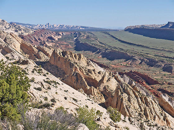
This scenic overlook atop Waterpocket Fold boasts breathtaking views of the Fold, Strike Valley, Tarantula and Swap Mesas, the Henry Mountain Mountains and Upper Muley Twist Canyon. The domes of Capitol Reef rise in the distance to the north.
- Distance: 0.9 - 5.9 miles (RT)
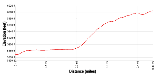
- Elevation: 5,850-ft. at Trailhead
Maximum elevation - 6,010-ft. - Elevation Gain: 160-ft.
- Difficulty: moderate
- Basecamp: Capitol Reef
- Region: South Central Utah
Trail Description - Strike Valley Overlook
Note: This trail description assumes you are starting the hike at the 4WD trailhead. If starting from the 2WD trailhead add 2.5 miles (one-way) or 5.0 miles (round-trip) to the mileage indicated below.
The trailhead for the Strike Valley Overlooks starts at the northeast end of the Strike Valley/Upper Muley Twist 4WD parking area. (See driving directions below.) The trail begins with a short traverse on a packed sand trail through pinyon pines and junipers and then curves to the right as it drops into a shallow wash. Here the trail ascends on easy grades along the left side of the sandy wash.
Soon the trail reaches slickrock where the route, marked by rock cairns, climbs to the base of a slickrock ramp. Ascend the ramp on moderately steep grades, reaching a saddle on the ridge atop Waterpocket Fall at 0.45 miles. Here you will find a large rock cairn marking to top of the climb. From here it’s easy to roam along the rim for great views of Strike Valley and the colorful formation of contorted rock along the east side of the Fold. The Henry Mountains, snowcapped in the spring, form the backdrop for Tarantula and Swap Mesas to the east/northeast. On a clear day you can see the while Navajo sandstone domes of Capitol Reef to the north. Nearer at hand you are surrounded by the white Navajo Sandstone domes comprising the crest of Waterpocket Fold.
Travel along this route is only recommended during the cool temperature of the spring and the fall. Be sure to carry plenty of water, there are no dependable water sources along the route. Never enter the canyon or climb to the top of the Fold is the weather is taking a turn for the worse.
This short hike requires a very long drive. The hike is best done in conjunction with other activities in the Waterpocket Fold District of Capitol Reef, heading to/from the Bullfrog Marina area of Lake Powell via the Notom Road or traveling to/from the Escalante region via the Burr Road. For a longer hike in the Waterpocket Fold area I highly recommend the Upper Muley Twist loop, leaving from the same trailhead.
Elevation Profile
Driving Directions
Capitol Reef Visitor Center: Turn left out of the Visitor Center on Campground Road and after 100-ft. turn right onto UT 24 East. Drive 9.0 miles and turn right onto the Notom-Bullfrog Road. (The road, signed for Notom and Lake Powell, is initially paved but turns to a good gravel/dirt road after 5.0 miles.) Follow the Notom Road for 32.5 miles and then turn right (southwest/west) onto the Burr Trail Road. Drive 3.2 miles on the Burr Road, which climbs switchbacks, passes the trailhead for Lower Muley Twist and then heads northwest. Turn right onto the road signed for Strike Valley Overlook / Upper Muley Twist. Reach the 2WD parking area after 0.4 miles. Hikers with a 4WD should continue another 2.5 miles to the 4WD trailhead. Under good conditions a high clearance vehicle should also be able to reach the trailhead. Check at the Capitol Reef Visitor Center for current road conditions before driving into the canyon with high clearance two-wheel drive vehicle.
From Bullfrog: Head northeast on UT 276 W /Ferry Road for 4.4 miles and turn left onto BLM 12000/Notom Road. After driving 30.3 miles turn left (west) onto the Burr Trail Road. Drive 3.2 miles on the Burr Road, which climbs switchbacks, passes the trailhead for Lower Muley Twist and then heads northwest. Turn right onto the road signed for Strike Valley Overlook / Upper Muley Twist. Reach the 2WD parking area after 0.4 miles. Hikers with a 4WD should continue another 2.5 miles to the 4WD trailhead. Under good conditions a high clearance vehicle should also be able to reach the trailhead. Check at the Capitol Reef Visitor Center for current road conditions before driving into the canyon with high clearance two-wheel drive vehicle.
Trail Resources
- Trail Photo Gallery
- Trail Maps
- Basecamp(s) Information: Capitol Reef
- Region Information: South Central Utah
- Other Hiking Regions in: Utah