Sand Dune, Broken and Tapestry Arches Loop 
Distance: 1.6 - 2.7 miles
Arches National Park, near Arches in Southeast Utah
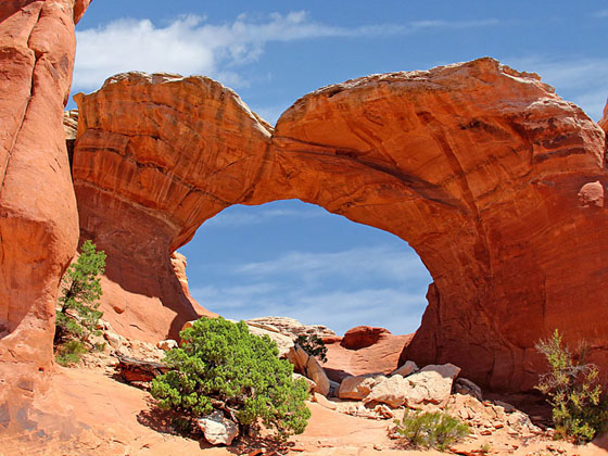
Broken Arch
This moderately-easy family hike visits three interesting arches; Sand Dune Arch, Broken Arch and Tapestry Arch, and travels through scenic desert landscape on uncrowded trails, a rarity in Arches National Park.
- Distance: 1.6 - 2.7 miles (Loop)
- Elevation: 5,180-ft. at Trailhead
Maximum elevation - 5,275-ft. - Elevation Gain: 95-ft.
- Difficulty: easy-moderate
- Basecamp: Arches / Moab
- Region: Southeast Utah
Trail Description - Sand Dune, Broken and Tapestry Arches Loop
1.6 mile loop (out and back hike to Sand Dune and Broken Arches) 2.7 miles loop (including the side trip to Tapestry Arch)
The loop hike to Sand Dune, Broken and Tapestry Arches starts at the Sand Dune Arch trailhead near the end of the Arches Scenic Drive and just south of the Devil’s Garden Campground (see driving directions below). Along the way the path travels through desert flats, wanders down narrow sandstone passages and scrambles under an arch. Fine views encompass sandstone fins, towers and pinnacles along with distant vistas of the La Sal Mountains.
From the Sand Dune Arch trailhead follow the broad path for a short distance toward a section of sandstone fins. Soon you reach a signed junction. Straight ahead is Broken Arch. We turn right on a short spur trail toward Sand Dune Arch. The sandy path travels through a passage between two rows of sandstone fins and soon comes to Sand Dune Arch, on the right, at 0.15 miles. The span is flanked by fins. Beneath the arch is its namesake sand dune.
To visit Broken Arch, return to the main trail and turn right, traversing a desert flat populated with sagebrush, blackbrush, Mormon tea and junipers. At 0.6 miles reach a signed “T” junction and the beginning of the loop. Ahead is an interesting section of sandstone fins, towers and weirdly eroded rock formations. Turn right toward Broken Arch. The trail to the left, pointing toward the campground, will be used on the return leg of the hike.
The path now skirts the edge of the formation. Views soon open to Broken Arch, located along a fin to the northeast. As you approach the arch the trail ascends slickrock slopes, reaching the base of the 60-ft. wide arch at 0.8 miles. A crack that runs through the top of the span and gives the arch its name is now clearly visible. Scramble up the slickrock slope to stand under the arch and enjoy the views.
Many people turn around at this point and return to the trailhead for a 1.6 mile hike. If time and energy permit, I recommend completing the rest of the loop by follow the trail that climbs under the arch and then follows an undulating path over slickrock and then pack sand. Along the way the trail travels between two rows of fins, passes sculpted sandstone knobs, wanders through some Pinyon Pines and enjoy views of Devil’s Garden to the northeast.
At 1.3 miles reach the junction with the spur trail branching right toward Tapestry Arch. This highly worthwhile detour adds 0.3 miles to the hike. The photogenic arch is situated along a slightly curved fin and flanked by two alcoves. A sandstone cliff rises behind the arch. Climb underneath the arch for nice views.
Return to the main trail and continue along the loop to the Devil’s Garden Campground near a restroom at 1.8 miles. Turn left and walk along the campground road for 0.1 miles to find the continuation of the trail near campsite #51.
The path now ascends on moderate grades, climbing over packed sand and slickrock, to the high point of the loop at 2.1 miles. From the high point enjoy fine views of the surrounding area. The trail now descends on moderately-steep grades, passing through narrow slots between sandstone fins. Soon the trail emerges onto the desert flats and reaches a signed trail junction and the end of the loop at 2.3 miles. Turn right and follow the trail back to the Sand Dune Arch trailhead at 2.7 miles.
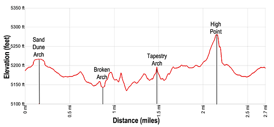
Elevation Profile
Driving Directions
From Moab, UT: From Center Street and Main Street/US 191 in Moab, head north on Main Street/US 191 N for 4.6 miles and then turn right on the Arches Entrance Road. Pass thru the kiosk where you pay your entrance fee. A short distance beyond the kiosk is the right turn for the Visitor Center (0.7 miles from the entrance). The Visitor Center is a good place to see exhibits on the park, obtain information and check on current conditions.
Beyond the Visitor Center follow the road, now called the Arches Scenic Drive, for 16 to the Sand Dune Arch trailhead, located on the right (east) side of the road.
Trail Resources
- Trail Photo Gallery
- Trail Maps
- Basecamp(s) Information: Arches / Moab
- Region Information: Southeast Utah
- Other Hiking Regions in: Utah