Details: Devil's Garden 
Distance: 1.8 - 7.7 miles (loop)
Arches National Park, near Arches in Southeast Utah
Hike Facts
- Distance: 1.8 - 7.7 miles (loop)
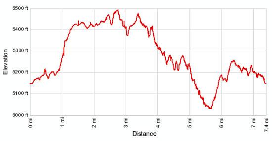
- Elevation: 5,220-ft. - 5,510-ft.
- Elevation Gain: 20-ft. - 290-ft.
- Difficulty: moderate
- Trail Highlights: See Trail Intro
- Basecamp(s): Arches / Moab
- Region: Southeast Utah
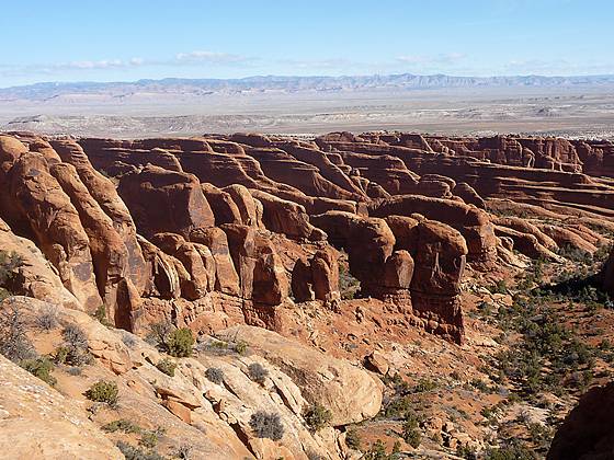
Seven amazing arches set amid a landscape of weird and wonderful sandstone fins, spires and knobs are the rewards for hiking the Devils Garden Trail, my favorite trail in Arches National Park.
Trailhead to Landscape Arch
Distance from Trailhead: 1.8 miles (round trip)
Ending/Highest Elevation: 5,240-ft.
Elevation Gain: 20-ft.
From the trailhead, located at the north end of the parking area (see driving directions below), follow the wide, well graded dirt/gravel trail as it climbs northwest on gentle grades through sandstone fins. At 0.2 miles pass a short spur trail on the right (east) leading to Tunnel and Pine Tree Arches.
The detour to these two small arches, just over 0.5 miles round trip, provides a nice preview of the coming attractions. To reach the arches descend along the spur trail for a short distance to a “Y” intersection. The trail to the right quickly leads to Tunnel Arch (25.5-ft. wide and 14-ft. high), a good example of a relatively young arch eroded entirely within a massive 14-ft. thick sandstone wall. A short hike to the left leads to Pine Tree Arch (46-ft wide and 48-ft. high), named for the Pinion Pine framed in its opening. (Note: The mileage on the remainder of this hiking description does not include the side trip to Tunnel and Pine Arches.)
After viewing the two arches return to the main trail and continue ascending northwest on easy grades. At 0.8 miles pass a turnoff to the right (east) that will be used as the return leg of the Primitive Loop.
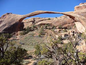
Shortly past the junction reach the viewpoint for Landscape Arch, 0.9 miles from the trailhead. This graceful, 77-ft. high arch is one of the world’s longest stone spans, stretching 290-ft., yet is only 6-ft. thick at it center.
The arch was almost five feet thicker until September 1, 1991 when loud cracking and popping noises sent visitors sitting under the arch running. Soon small pieces of the arch began to fall and then a 60-ft. long slab of rock dropped from the underside of the arch’s thinnest section. When the dust settled 180-tons of fresh rock debris lay scattered beneath the arch. Thankfully no one was hurt. Due to safety concerns visitors are no longer permitted to hike beneath the arch.
Before leaving the viewpoint look up to see Partition Arch, located high on a sandstone wall to the right (northwest) of Landscape Arch.
To Double O Arch
Distance from Trailhead: 4.2 miles (round trip)
Ending/Highest Elevation: 5,510-ft.
Elevation Gain: 290-ft.
Beyond Landscape Arch the trail becomes more challenging, climbing steeply up a slickrock ramp between two sandstone fins. Just beyond the top of the ramp the trail reaches the junction with the spur trail to Navajo and Partition Arches on the left (southwest), 1.25 miles from the trailhead.
Visiting both arches, which is highly recommend, will add an addition 0.8 miles to the hike. To see the arches turn left onto the spur trail. In a very short distance arrive at a second junction. Continue straight ahead for Navajo Arch or left (southeast) for Partition.
The trail to Navajo Arch soon turns left (southeast) and wanders between two sandstone fins. Reach the arch, located at the base of the fin on your left (east), 0.3 miles from the main trail junction. The 40.5-ft. span, one of the few arches in the park with a flat, sand covered floor, offers a nice shady spot to rest on a hot day.
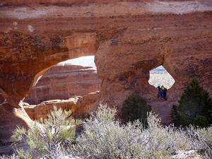
To see Partition Arch turn left (southeast) at the second junction and follow the spur trail as it ascends between two sandstone fins for just under 0.2 miles. The photogenic arch is located along the fin to the left (east) of the trail and is a composed of a large, nearly cylindrical opening measuring 27.5-ft wide and 26-ft high and a smaller opening to the right of the larger arch, measuring 8.5-ft wide by 8-ft. high. The openings nicely frame views of the eastern section of the park.
Beyond the junction to Navajo and Partition Arches the main trail follows an ascending traverse across packed sand and slickrock with great views of the La Sal Mountains to the south and the aptly named Fin Canyon to the northeast. A section of this trail climbs along the spine of a fin with drop offs on both side. People with a fear of heights may want to avoid this part of the trail.
Reach the spur trail to the left (southwest) leading to Double O Arch, 0.8 miles past the Navajo/Partition Arch junction. (The total distance, without side trips, from the trailhead to Double O Arch is 2.1 miles.) Beautiful Double O is a stacked arch with a large upper opening, measuring 71-ft wide and 45-ft. high, sitting atop a smaller opening that is 21-ft. wide and 11-ft. high.
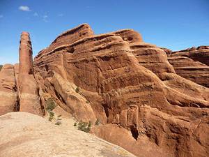
Just 0.1 miles beyond the spur trail to Double O Arch reach the junction for the Dark Angel Trail and the Primitive Trail. Dark Angel is a tall rock spire, the remnant of a once high, narrow fin. The 0.8 round trip hike to the spire climbs to a small hill with panoramic views that extend west across the Salt Valley to Klondike Bluffs, an interesting area of sandstone fins and knobs, and south to the La Sal Mountains. On the return trip enjoy good views of Double O’s upper opening.
Dark Angel and the Primitive Loop
Distance from Trailhead: 7.7 miles (loop)
Ending/Highest Elevation: 5,500-ft.
Elevation Gain: 284-ft.
The Primitive Trail is a great option for hikers looking for a longer, more challenging trail with a degree of solitude not found elsewhere in the park. Hikers should be comfortable following a cairned route, negotiating steep slickrock friction pitches and traveling through sandy washes. Do not attempt the trail during wet or icy conditions.
From the junction the primitive trail heads northeast, descending through an interesting canyon flanked by rows of massive sandstone fins. After hiking for a little over 0.4 miles watch for a sign on your right (south) marking the spur trail to Private Arch, a worthwhile detour. The 0.6 mile round trip spur trail heads southeast, traveling between sandstone fins to a seclude arch tucked along the bottom of a low fin. Just to the south of the arch is a slickrock ramp leading to the top of a sandstone fin with great views of the aptly named Fin Canyon. Retrace your steps to the Primitive Trail when you are done exploring the area around the arch.
Not far beyond the junction with Private Arch the Primitive Trail curves to the right (southeast) and descends for a half mile through massive sandstone fins along slickrock ramps and ledges. Be careful in the areas where the trail climbs down steep slickrock friction pitches.
As the trail reaches Fin Canyon the grade abates and the route turns left (northeast), descending along the canyon’s wash on easy grades for 0.2 miles. As you hike, watch for rock cairns marking the route through the wash. A sign indicates where the trail leaves the wash and climbs out of the canyon.
The trail now ascends on moderate grade through desert scrub. Along the way enjoy nice views of the sandstone fins and knobs to the west and north of the trail. After climbing for 0.7 miles the trail crests a rise where wonderful views open to the La Sal Mountains to the south. The boot beaten path now descends on easy grades back to the junction with the Devils Garden trail, 6.4 miles from the trailhead. As you descend, be sure to look right (west) for views of Landscape Arch. At the junction, turn left on the Devil’s Garden trail and walk 0.8 miles back to the trailhead.
Total distance for the loop hiking, excluding the side trip to Tunnel and Pine Arches is 7.2 miles. Total distance for the loop hike, including all side trails is 7.7 miles.
This hike is best done in the spring and fall when temperatures are milder. Hiking is not recommended during the summer when temperatures often exceed 100 degrees F. Be sure to carry plenty of water. Water is only available at the Visitor Center, the Devil’s Garden trailhead and at the Devil’s Garden campground.
Elevation Profile
Driving Directions
From Moab: Drive northwest on US 191-N for 4.6 miles and turn right onto the Arches National Park Entrance Road. Travel along the road for 0.6 miles to the park entrance station where you pay park fees and obtain park brochures. (First time visitors should stop at the Visitor Center, located on the right 0.2 miles up the road from the Entrance Station to view the exhibits and obtain information about current park conditions.)
Beyond the entrance station drive 17.8 miles to the end of the main road (now called the Arches Scenic Drive) to the Devils Garden parking area. Along the way pass turnoffs for Windows Area at 9.3 miles and Delicate Arch at 11.5 miles. The trailhead is located at the north end of the parking area near a bulletin board and bathrooms. Note: The parking area fills quickly during busy periods.
Trail Resources
Trail Intro / Trail Photo Gallery / Trail Map
Basecamp(s) Information:
Arches / Moab
Region Information:
Southeast Utah
Other Hiking Regions in:
Utah