Horse Collar Ruin Overlook 
Distance: 0.6 miles
Natural Bridges National Monument, near Blanding in Southeast Utah
Square Kiva and Horse Collar Ruins
A short jaunt leads to the Horse Collar Overlook offering birds-eye-views of Horse Collar Ruin, a well-preserved ancestral Puebloan site, along with panoramic views of White Canyon and Deer Flat Mesa.
- Distance: 0.6 miles (RT)
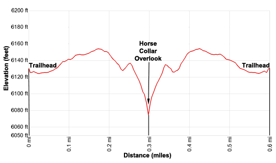
- Elevation: 6,095-ft. at Trailhead
Maximum elevation - 6,155-ft. - Elevation Gain: 60-ft.
- Difficulty: moderate
- Basecamp: Bears Ears NM / Natural Bridges NM
- Region: Southeast Utah
Trail Description - Horse Collar Ruin Overlook
Horse Collar Ruin, one of the better-preserved ancestral Puebloan ruins in Natural Bridges National Monument, is named after a structure with doors that looks like horse collars. The ruins are believed to have been last occupied over 700-years ago.
The easiest way to see the ruins in to take a short hike that starts from the loop road and then crosses the mesa to the Horse Collar Ruin Overlook. The trailhead is located 0.8 miles past the Sipapu Bridge Trailhead. (See the driving directions below for more information.) The trailhead is located at the west end of the parking area.
The well-marked, undulating trail travels along pack dirt/slickrock surfaces as it crosses a low hill. Atop the hill great views open to White Canyon and Deer Flats Mesa rising to the north/northwest.
After cresting the hill, the path curves to the left (west) as it drops down slickrock ramps to the viewpoint. Metal fences along the last section of trail protect hikers from steep drop-offs.
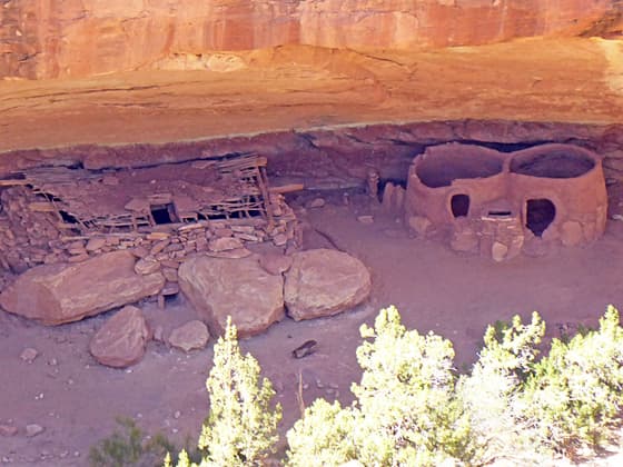
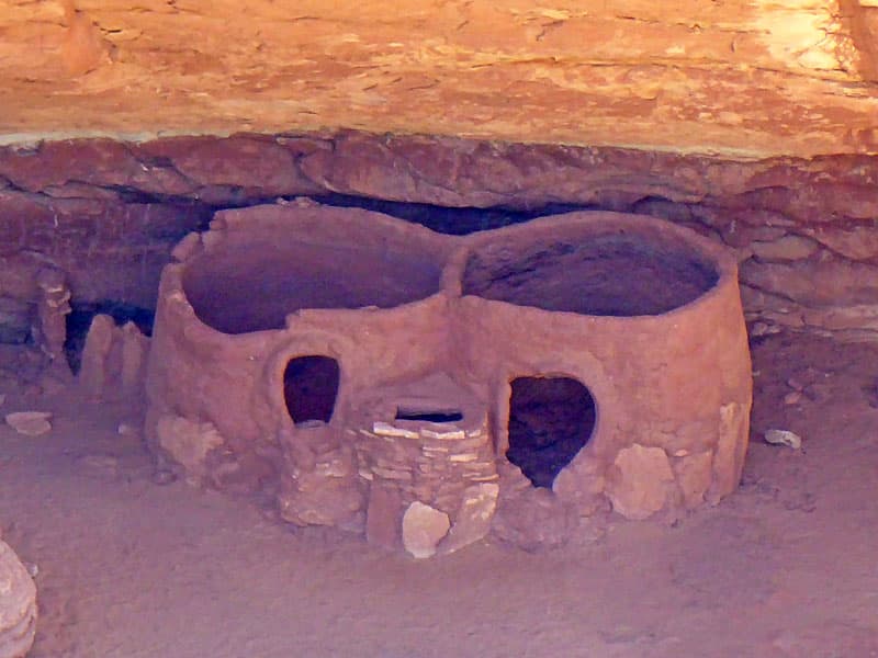
Below the overlook are two alcoves with ruins. The first, and largest of the alcoves, includes a ruin consisting of two rounds structures with horse collar-shaped doors. There also appears to be a small vent or rectangular opening between the doors of the structures.
To the left of the rounded structures is a square kiva built between some large boulders and the back wall of the alcove. The roof of the kiva is largely intact and composed of large wood roof beams overlain by smaller branches, then by reeds and thin sticks. Large sections of the mesh are still covered with mud.
Use the view scope at the overlook or bring a pair of binoculars or a camera with a zoom lens to see the roof construction in more detail. Look closely at the kiva to see a vent between two of the large boulders. This is the opening for the ventilation shaft for the fire pit located near the center of the kiva. To the left of the kiva are wall fragments for a row of structures along the back wall of the alcove.
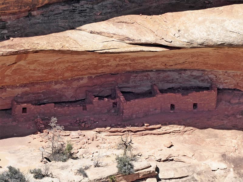
After viewing the ruins in the large alcove look to the left of the large alcove to see a shallow alcove that contains ruins with well preserved walls. There may well have been additional ruin in this alcove, although it is hard to see from this perspective.
After enjoying the views of the ruins and White Canyon, retrace your steps to the trailhead for you 0.6 miles round-trip hike.
Elevation Profile
Driving Directions
From Blanding: Drive south on US 191 S for 4 miles and then turn right (west) on UT-95 N. Follow UT-95 for 30.2 miles and then turn right (north) on UT-275 N, signed for Natural Bridges. Follow UT-275 N for 4.5 miles to the Visitor Center, on the right, where you need to pay the entrance fee for the national monument. After paying the fee continue on UT-275 for 0.5 miles to a “T” intersection and turn right on the one-way loop road circling the monument. Drive along the loop road for 2.9 miles to the Horse Collar Overlook Trailhead parking area. The parking area is 0.8 miles past the Sipapu Bridge Trailhead parking area.
From Bluff: From the corner of N 6th Steet and US-191 in Bluff, head north on US-191 for 21.8 miles and then turn left (west) on UT-95 N. Follow UT-95 for 30.2 miles and then turn right (north) on UT-275 N, signed for Natural Bridges. Follow UT-275 N for 4.5 miles to the Visitor Center, on the right, where you need to pay the entrance fee for the national monument. After paying the fee continue on UT-275 for 0.5 miles to a “T” intersection and turn right on the one-way loop road circling the monument. Drive along the loop road for 2.9 miles to the Horse Collar Overlook Trailhead parking area. The parking area is 0.8 miles past the Sipapu Bridge Trailhead parking area.
From Mexican Hat: Head east on US 163 N for 3.9 miles and turn left (north) on UT 261 N. Follow UT261 N for 32.7 miles to its end at UT 95. (Note: a short section of UT-261 climbs steep gravel switchback up the Moki Dugway.) Turn left (west) on UT 95 N. Follow UT 95 N for 1.8 miles and turn right (north) on UT-275 N, signed for Natural Bridges. Follow UT-275 N for 4.5 miles to the Visitor Center, on the right, where you need to pay the entrance fee for the national monument. After paying the fee continue on UT-275 for 0.5 miles to a “T” intersection and turn right on the one-way loop road circling the monument. Drive along the loop road for 2.9 miles to the Horse Collar Overlook Trailhead parking area. The parking area is 0.8 miles past the Sipapu Bridge Trailhead parking area.
Trail Resources
- Trail Photo Gallery
- Trail Maps
- Basecamp(s) Information: Bears Ears NM / Natural Bridges NM
- Region Information: Southeast Utah
- Other Hiking Regions in: Utah