South Fork Mule Canyon 
Distance: 2.0 - 9.2 miles (round trip)
BLM, Monticello, Utah office, near Blanding in Southeast Utah
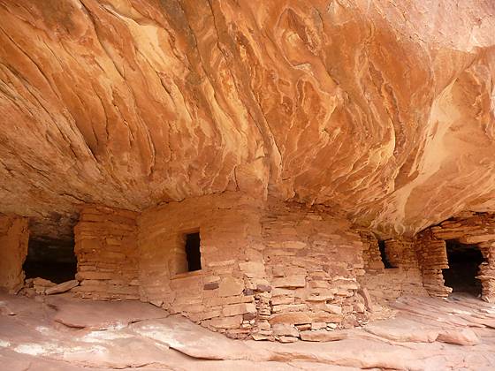
Closeup of the House on Fire
This easy hike offers an excellent opportunity to discover well preserved ruins tucked into alcoves and along the walls of side canyons in the scenic South Fork of Mule Canyon.
See Trail Detail/Full Description
- Distance: 2.0 miles (round trip) to House on Fire
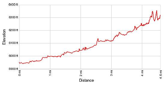
9.2 miles (round trip) to Last Ruins - Elevation: 5,940-ft. at Trailhead
5,995-ft. at House on Fire
6,290-ft. at Last Ruins - Elevation Gain: 55-ft. to House on Fire
450-ft. to Last Ruins - Difficulty: easy-moderate
- More Hikes in:
Bears Ears NM / Southeast Utah
Why Hike South Fork Mule Canyon
The South Fork of Mule Canyon is a great place to discover Ancestral Puebloan ruins in a natural setting. The ruins, sheltered in alcoves and beneath overhangs along the canyon’s north wall, were occupied by Native Americans over 700 years ago.
The hike up the canyon is relatively easy, traveling along the wash and its adjacent benches. Initially the canyon’s walls are only 80-ft. high. As you proceed up canyon the walls grow in stature and the canyon becomes more scenic.
A little under a mile from the trailhead careful observers will discover the first ruin. There are at least six more sites within the next four miles. Be sure to bring binoculars to facilitate your search.
Exploring the canyon and discovering the ruins is fun and rewarding. Remember these fragile ancient treasures are priceless and irreplaceable. Please treat them with reverence and respect.
Elevation Profile
Trail Resources
Trail Detail/Full Description / Trail Photo Gallery / Trail Map
Basecamp(s) Information:
Bears Ears NM
Region Information:
Southeast Utah
Other Hiking Regions in:
Utah