Owachomo Bridge 
Distance: 0.1 - 0.6 miles
Natural Bridges National Monument, near Blanding in Southeast Utah
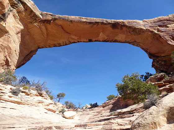
View of Owachomo
The Owachomo Bridge is the easiest to visit and the most elegant of the three spans in Natural Bridges National Monument. A half mile (RT) trail descends to and then crosses under this photogenic bridge, offering views of this natural wonder from a variety of angles.
- Distance: 0.1 - 0.6 miles (RT)
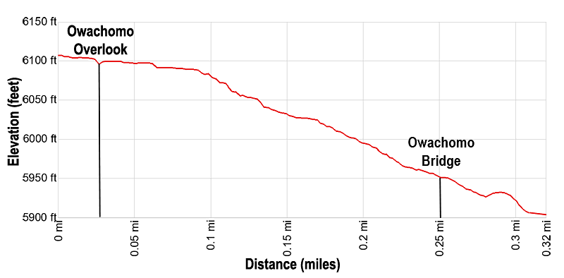
- Elevation: 6,120-ft. at Trailhead
Maximum elevation - 5,930-ft. - Elevation Gain: -190-ft.
- Difficulty: moderate
- Basecamp: Bears Ears NM / Natural Bridges NM
- Region: Southeast Utah
Trail Description - Owachomo Bridge
Natural Bridges National Monument (6,200-ft), situated high atop Cedar Mesa, illustrates the power of water in shaping a high desert landscape. Intermittent streams have cut two deep canyons and three massive bridges in sandstone formed from what was once the shore of an ancient sea that covered the area.
Owachomo is a stunning example of the forces of erosion. The bridge, just 9-ft. thick, is the most fragile and elegant of the monument’s three spans. It is also the smallest, with a height of 106-ft. and a span of 180-ft., and commonly through to be the oldest. It rises 108 feet above the stream bed of a short, unnamed canyon at its confluence with Armstrong Canyon.
A 9.0-mile, one-way scenic loop road provides access to overlooks and trailheads in the monument. The trail to Owachomo Bridge is the located at the last trailhead along the loop road. (See driving directions below.) Of the 3 trails leading down to the bridges in the monument this one is by far the easiest.
From the parking area a paved walkway soon leads to an overlook along the rim of the mesa with good views of the bridge. Owachomo means “rock mound” in Hopi, and is named after the rock formation on top of the east end of the bridge. From this perspective you get a good view of mound and the bridge along with slickrock walls rimming the south/southwest side of Armstrong Canyon. Bears Ears, rounded twin buttes, rise to the northeast. (The Bears Ears formation is now part of the Bears Ears National Monument which completely encircles Natural Bridges National Monument.)
Backtrack a short distance from the overlook to the junction where the trail to the bridge heads west. The well-engineered path descends on moderate to moderately-steep grades down the north slopes of the unnamed side canyon using a series of stone steps, slickrock ramps and ledges, losing 190-ft. in 0.25 miles. Along the way enjoy ever improving views of the bridge.
The path leads under the bridge with grand views of the span from a variety of angles. On the south side of the bridge the path descends to a slickrock bench at 0.3 miles and then then a junction with the Natural Bridge loop trail heading up Armstrong Canyon toward Kachina Bridge.
When you are done admiring the bridge, retrace your steps to the trailhead for a 0.5 mile hike.
Elevation Profile
Driving Directions
From Blanding: Drive south on US 191 S for 4 miles and then turn right (west) on UT-95 N. Follow UT-95 for 30.2 miles and then turn right (north) on UT-275 N, signed for Natural Bridges. Follow UT-275 N for 4.5 miles to the Visitor Center, on the right, where you need to pay the entrance fee for the national monument. After paying the fee continue on UT-275 for 0.5 miles to a “T” intersection and turn right on the one-way loop road circling the monument. Drive along the loop road for 6.2 miles to the Owachomo Bridge trailhead parking area.
From Bluff: From the corner of N 6th Steet and US-191 in Bluff, head north on US-191 for 21.8 miles and then turn left (west) on UT-95 N. Follow UT-95 for 30.2 miles and then turn right (north) on UT-275 N, signed for Natural Bridges. Follow UT-275 N for 4.5 miles to the Visitor Center, on the right, where you need to pay the entrance fee for the national monument. After paying the fee continue on UT-275 for 0.5 miles to a “T” intersection and turn right on the one-way loop road circling the monument. Drive along the loop road for 6.2 miles to the Owachomo Bridge trailhead parking area.
From Mexican Hat: Head east on US 163 N for 3.9 miles and then turn left (north) on UT 261 N. Follow UT261 N for 32.7 miles to its end at UT 95. (Note: a short section of UT-261 climbs steep gravel switchback up the Moki Dugway.) Turn left (west) on UT 95 N. Follow UT 95 N for 1.8 miles and then turn right (north) on UT-275 N, signed for Natural Bridges. Follow UT-275 N for 4.5 miles to the Visitor Center, on the right, where you need to pay the entrance fee for the national monument. After paying the fee continue on UT-275 for 0.5 miles to a “T” intersection and turn right on the one-way loop road circling the monument. Drive along the loop road for 6.2 miles to the Owachomo Bridge trailhead parking area.
Trail Resources
- Trail Photo Gallery
- Trail Maps
- Basecamp(s) Information: Bears Ears NM / Natural Bridges NM
- Region Information: Southeast Utah
- Other Hiking Regions in: Utah