Details: Owl Creek Canyon to Nevill's Arch 
Distance: 9.6 miles (round trip)
BLM, Monticello, Utah office, near Blanding in Southeast Utah
Hike Facts
- Distance: 9.6 miles (round trip)
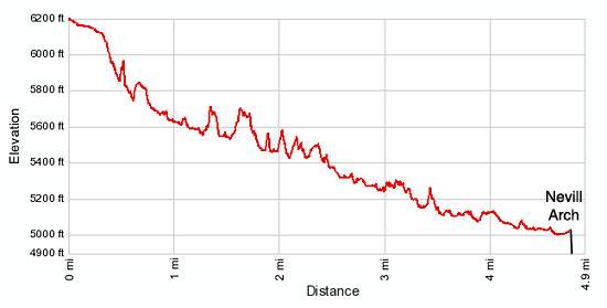
- Elevation: 6,190-ft. - 5,000-ft.
- Elevation Gain: -1,190-ft.
- Difficulty: strenuous
- Trail Highlights: See Trail Intro
- Basecamp(s): Blanding
- Region: Southeast Utah
This strenuous hike travels down stunningly beautiful Owl Creek Canyon to Nevill’s Arch, an imposing span located atop a high fin.
Trailhead to Owl Creek Canyon
The trailhead for Owl Creek Canyon is located down County Road 253, a dirt road off UT-261 that is 1.1 miles south of the Kane Gulch Ranger Station. (See driving directions below.) From the northeast end of the trailhead parking area follow the signed, dirt trail heading southeast through sage brush and junipers for about 140 yards. Turn right (south) onto a cairned slickrock route that descends the upper end of the Owl Creek drainage on easy grades, reaching the rim of Owl Creek Canyon at 0.3 miles. From this vantage point awesome views extend south into the deep, impressive canyon flanked by steep multi-hued sandstone walls.
To avoid a drop-off in the wash the cairned trail briefly loops to the left (east) and descends a steep route down the canyon’s east wall to the slickrock wash. Drop down the wash along a cairned route for a short distance. To circumvent a huge pour-off the trail again turns left (east), traversing a ledge along the canyon’s east wall and then turns right (southwest) zigzagging down a steep rocky slope. Scattered junipers and desert scrubs cling to the steep hillside. As you descend look down to your right see a ruin nestled along the northwest side of a large alcove beneath the pour-off.
After losing about 150-ft. the trail reconnects with the wash. If you wish to visit the ruin head up the slickrock wash. It will be necessary to negotiate a few minor pour-offs in the wash along the way.
The ruins consist of a nicely preserved kiva, with many of its roof beams still intact, and what appear to be granaries. The ruins are very fragile. To not sit/walk on the walls, attempt to enter the structures or touch anything. Treat the structures with reverence and respect so the future hikers can enjoy this interesting site.
After visiting the ruins retrace your steps back down the wash and follow the trail as it traverses steep rocky slopes along the canyon’s west wall. At 0.6 miles the trail turns right (northwest) into a minor side canyon, traveling along a slickrock ledge. Soon the trail makes a sharp a ”U” turn, descending a slickrock slope via friction pitches back to the main canyon where rock cairns lead down a very steep slope to the canyon floor.
Reach the floor of the scenic canyon 0.8 miles from the start after losing about 420-ft in 0.5 miles. Note the northwest trending side canyon near the spot where you hit the wash. This is a good landmark to gauge your progress on the return leg of the hike.
The cairned trail heads down the wash but is soon forced onto a ledge along the left (eastern) side of the drainage to avoid a boulder jam. Over the course of the hike the trail will frequently leave the wash and traverse boot beaten paths, marked with rock cairns, that cross benches and slickrock ledges to avoid obstacles in the wash.
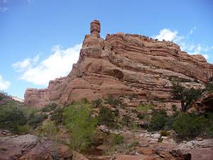
As you descend the canyon you many find running water or small pools in sections of the wash. Along these areas the brush thickens. Desert shrubs and junipers are joined by Cottonwoods and willows. Sculpted sandstone bays with steep chutes start to appear along the canyon’s walls, which now tower almost 500-ft. above the wash.
At 2.1 miles reach a large pour-off. To circumvent this obstacle follow the cairned path to the left (north) along a ledge. Soon the ledge trail curves left (north) into a side canyon. Toward the head of the canyon the route drops off the ledge and makes a “U” turn to the right (south), descending a steep, rocky trail to the floor of the side canyon before traveling back to the main canyon.
A short detour to the left (east) where the canyons intersect leads to a large plunge pool at the base of the large pour-off. Small hanging gardens cling to the slickrock walls rimming the pool. The adjacent benches harbor some nice campsites.
At 2.9 miles the trail curves left (southeast) at the confluence of a prominent west trending side canyon. This is a pretty section of the canyon with soaring walls stained with desert varnish and topped by knobs and spires. Small pools in the wash support cottonwoods and willows.
Just beyond the confluence is a small pour-off and plunge pool. The trail detours to the left (north), traversing a slickrock ledge and then a rocky slope along the canyon’s north wall for a quarter mile before dropping steeply back down to the wash. Make note of where the trail reenters the canyon. It is easy to miss this turn on the return trip.
The walking now becomes easier. At 3.5 miles the trail and the canyon bend to the left (north). For the next mile the trail echoes the canyon’s winding course. Where possible, the route crosses benches to cutoff meanders in the stream bed. Along the way enjoy ever improving views of the wind and rain sculpted sandstone walls. Amphitheaters open around every bend, delineated by huge fins topped by knobs and eroded towers.
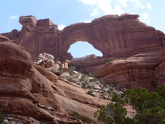
Nevill’s Arch comes as a surprise as you round a bend in the canyon at 4.6 miles. The imposing arch, with a span of 140-ft and an opening height of 80-ft., is located high atop a massive fin extending from the canyon’s northeast wall. To the south of the arch the fin is eroded into collection of bizarre shaped towers, knobs and hoodoos. Use trails, heading northeast across the bench beneath the arch, lead to viewpoints and campsites. The one-way distance to a nice viewpoint below the arch is 4.8 miles.
The arch viewpoint makes a great spot of lunch and the perfect turnaround spot of day hikers. As you retrace your steps up canyon look for ruins about three-quarters of the way up the canyon wall, at 4.4 and 4.2 miles from the trailhead. The ruins, located in south facing alcoves, are easier to spot on the return trip. Binoculars or the zoom lens of a camera will help you to see the sites.
Backpackers can continue down canyon from Nevill’s Arch for 2.0 miles to the junction with Fish Creek Canyon. A nice loop trip travels 8.1 miles up Fish Creek Canyon, climbs out of the canyon and then travels 1.5 miles across the mesa back to the parking area. The 16.4 mile route is generally done over 2-3 nights and requires a permit available at the Kane Gulch Ranger Station. See the BLM Backpacking Permits page for more information.
Note: Backpackers may want to take some ropes to lower their packs down some of the steeper sections of the canyon
Elevation Profile
Driving Directions
From Blanding: Drive south on US 191 S for 4 miles and turn right (west) on UT-95 N. Follow UT-95 for 28.4 miles and turn left (south) on UT-261 S. Head south on UT 261 for 5.0 miles and turn left (east) on the County Road 253, located between mile posts 27 and 28. The turn is 1.1 miles south of the Kane Gulch Ranger Station. There is a BLM sign setback from the highway marking the road to Fish and Owl Creek Canyons. Follow the dirt road (County Road 253) for 5.2 miles to the trailhead parking area. The road can be sandy and rough in places. The road becomes impassable during wet conditions. There is a kiosk and restrooms at the trailhead.
From Mexican Hat: Head north on US-163 for 3.9 miles and turn left (north) on UT-261 N. Follow UT-261 north for 27.7 miles and turn right (east) on the County Road 253, located between mile posts 28 and 27. There is a BLM sign setback from the highway marking the road to Fish and Owl Creek Canyons. Follow the dirt road (County Road 253) for 5.2 miles to the trailhead parking area. The road can be sandy and rough in places. The road becomes impassable during wet conditions. There is a kiosk and restrooms at the trailhead. Note: a short section of UT-261 climbs steep gravel switchback up the Moki Dugway.
Trail Resources
Trail Intro / Trail Photo Gallery / Trail Map
Basecamp(s) Information:
Blanding
Region Information:
Southeast Utah
Other Hiking Regions in:
Utah