Sipapu Bridge 
Distance: 0.8 - 1.4 miles
Natural Bridges National Monument, near Blanding in Southeast Utah
Beautiful view of Sipapu
This adventurous hike in Natural Bridges features spectacular views of the Sipapu Bridge and White Canyon. Metal ladders, stairs and railings facilitate the steep descent to the base of the stunning formation. The hike is can be shortened for an easier day.
- Distance: 0.8 - 1.4 miles (RT)
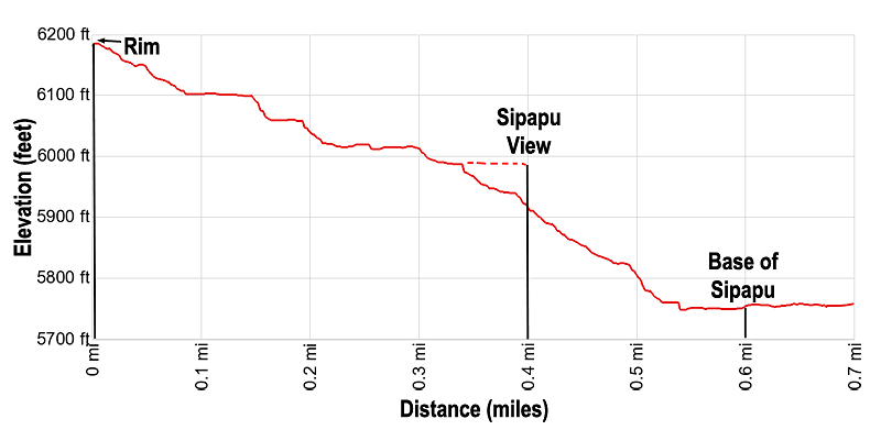
- Elevation: 6,185-ft. at Trailhead
Maximum elevation - 5,749-ft. - Elevation Gain: -436-ft.
- Difficulty: moderate-strenuous
- Basecamp: Bears Ears NM / Natural Bridges NM
- Region: Southeast Utah
Trail Description - Sipapu Bridge
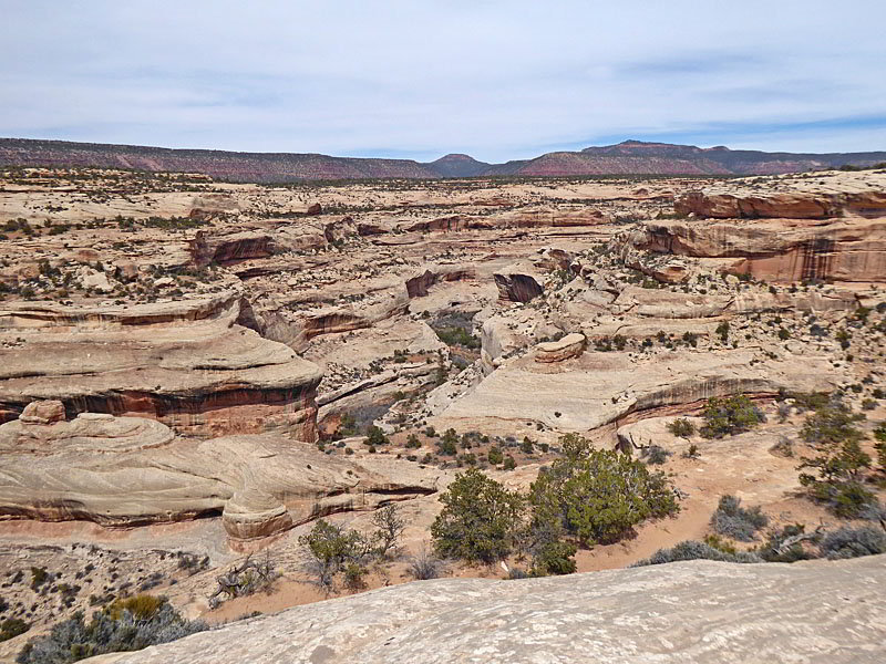
Natural Bridges National Monument (6,200-ft), situated high atop Cedar Mesa, illustrates the power of water in shaping a high desert landscape. Intermittent streams have cut two deep canyons; White and Armstrong, and three massive sandstone bridges; Sipapu, Kachina and Owachomo, formed from what was once the shore of an ancient sea that covered the area.
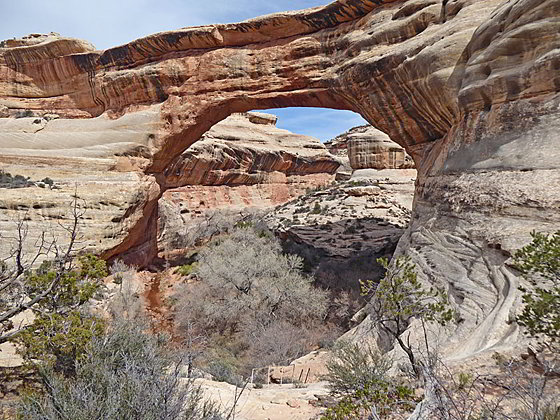
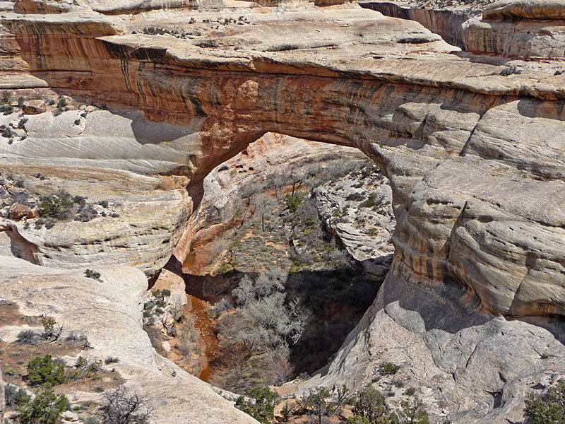
Sipapu is the largest and most stunning of the three bridges in the monument, with a span of 268-ft. and a height of 220-ft. William Douglas, the leader of a 1908 government surveying team, named the bridge Sipapu, a Hopi word that mean the “place of emergence’ or “the opening between two worlds.” The Hopi believe that a Sipapu is a hole through which their ancestors emerged from a lower, dark world into the present, sunlit one.
The bridge spans a scenic section of White Canyon and can be viewed from two overlooks along the Natural Bridges scenic loop road. But the most dramatic views on the bridge are found on this hike to the base of the bridge. There are two destinations on the hike, one atop a high ledge overlooking White Canyon and the other at the base of the bridge along the floor of White Canyon.
The Sipapu Bridge Trailhead is located at the fourth stop along the monument’s loop road. (See driving directions below.) The well-engineered trail starts atop the south rim of White Canyon and descends switchbacks down slickrock ramps and rock stairs. As you descend enjoy great views of White Canyon. Deer Flat Mesa and the Woodenshoe Butte rise in the distance to the north/northeast.
Soon the trail drops down a two-tiered metal staircase. The wide stairs are very sturdy and have good handrails. After a brief stint along a bench, the path reaches a set of handrails and a short metal ladder at 0.2 miles.
The ladder provides access to a broad, shady bench populated with large Douglas firs. Here the trail heads west. In a short distance the trail curves to the right (north), descends some steps and soon reaches a junction at 0.3 miles. The trail straight ahead along the bench leads to the Sipapu Bridge Viewpoint. The path to the right drops down to the base of Sipapu Bridge.
The Sipapu Bridge Viewpoint is the first destination on the hike and a recommended turnaround point for anyone who is uncomfortable on steep trails or hiking slickrock friction pitches. It is also a great side trip for everyone heading to the canyon bottom and the base of the bridge.
The trail to viewpoint passes a ruin on the left as it traverses the bench to a scenic overlook high above the south side of White Canyon at 0.4 miles. Here hikers enjoy stunning views of the Sipapu Bridge and White Canyon. With binoculars or a zoom lens you may be able to locate some ruins along a high ledge on the north side of the canyon.
Hikers heading for the base of the bridge should return to the junction and take the trail to the canyon bottom. Steep switchbacks head down the trail alternating between packed sand and slickrock. Rock steps aid the initial descent. As you descend enjoy ever improving views of Sipapu Bridge and the rugged, multi-hued walls of White Canyon, adorn with desert varnish.
At 0.5 miles the trail reaches slickrock. Here the trail curves to the right and descends steeply down slickrock slopes. Handrails and steps chiseled into the rock make the descent safer and easier. The final drop to the canyon floor requires hikers to climb downs two short metal ladders.
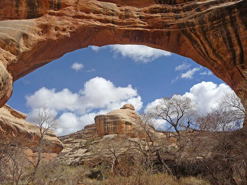
Reach the base of Sipapu Bridge at 0.6 miles. The bridge soars over 220-ft. above the trail, spanning the White Canyon wash. The bridge’s sculpted opening, stained with desert varnish, frames the canyon’s photogenic formations to the east. Water typically flows in the wash going under the bridge, although the recent drought is diminishing the flow. Use caution during and after heavy rains when the wash swells and can become dangerous.
For a different perspective, walk under the wash and a short distance to the east. At 0.7 miles there is a good turnaround point with fine views of the east side of the bridge. Shady areas along the stream and under the bridge provide nice places to sit and enjoy the views.
Retrace your step back to the trailhead when you done exploring the area around the bridge for a 1.4 miles round-trip hike with a total elevation gain and loss of 436-ft. The shorter hike to Sipapu View results in a 0.8 miles hike and 200-ft. elevation gain/loss.
Elevation Profile
Driving Directions
From Blanding: Drive south on US 191 S for 4 miles and then turn right (west) on UT-95 N. Follow UT-95 for 30.2 miles and then turn right (north) on UT-275 N, signed for Natural Bridges. Follow UT-275 N for 4.5 miles to the Visitor Center, on the right, where you need to pay the entrance fee for the national monument. After paying the fee continue on UT-275 for 0.5 miles to a “T” intersection and turn right on the one-way loop road circling the monument. Drive along the loop road for 2.1 miles to the Sipapu Bridge Trailhead parking area.
From Bluff: From the corner of N 6th Steet and US-191 in Bluff, head north on US-191 for 21.8 miles and then turn left (west) on UT-95 N. Follow UT-95 for 30.2 miles and then turn right (north) on UT-275 N, signed for Natural Bridges. Follow UT-275 N for 4.5 miles to the Visitor Center, on the right, where you need to pay the entrance fee for the national monument. After paying the fee continue on UT-275 for 0.5 miles to a “T” intersection and turn right on the one-way loop road circling the monument. Drive along the loop road for 2.1 miles to the Sipapu Bridge Trailhead parking area.
From Mexican Hat: Head east on US 163 N for 3.9 miles and then turn left (north) on UT 261 N. Follow UT261 N for 32.7 miles to its end at UT 95. (Note: a short section of UT-261 climbs steep gravel switchback up the Moki Dugway.) Turn left (west) on UT 95 N. Follow UT 95 N for 1.8 miles and turn right (north) on UT-275 N, signed for Natural Bridges. Follow UT-275 N for 4.5 miles to the Visitor Center, on the right, where you need to pay the entrance fee for the national monument. After paying the fee continue on UT-275 for 0.5 miles to a “T” intersection and turn right on the one-way loop road circling the monument. Drive along the loop road for 2.1 miles to the Sipapu Bridge Trailhead parking area.
Trail Resources
- Trail Photo Gallery
- Trail Maps
- Basecamp(s) Information: Bears Ears NM / Natural Bridges NM
- Region Information: Southeast Utah
- Other Hiking Regions in: Utah