First Fork of Slickhorn Canyon 
Distance: 4.9 - 9.0 miles (round trip)
BLM, Monticello, Utah office, near Blanding in Southeast Utah
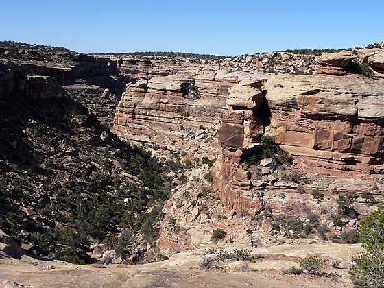
View into the First Fork of Slickhorn Canyon
Hikers making the very steep descent into the rugged, scenic First Fork of Slickhorn Canyon are rewarded with the opportunity to visit Perfect Kiva, one of the few kivas on Cedar Mesa that hikers are permitted to enter.
See Trail Detail/Full Description
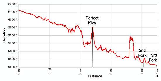
- Distance: 4.9 miles (round trip) to Perfect Kiva
9.0 miles (round trip) to Third Fork of Slickhorn Canyon - Elevation: 6,120-ft. at Trailhead
5,630-ft. at Perfect Kiva
5,430-ft. at Third Fork of Slickhorn Canyon - Elevation Gain: -490-ft. to Perfect Kiva
-690-ft. to Third Fork of Slickhorn Canyon - Difficulty: moderate-strenuous
- More Hikes in:
Bears Ears NM / Mexican Hat / Southeast Utah
Why Hike First Fork of Slickhorn Canyon
This scenic hike explores one of the lesser visited canyon systems on Cedar Mesa. The route into the First Fork of Slickhorn Canyon provides quick access to a use trail leading to a large alcove containing the ruins known as Perfect Kiva, an amazingly well preserve kiva with its roof still intact. [Hikers who tackle the steep ascent to the alcove are rewarded with the opportunity to descend into the kiva.] This is one of the few kiva’s on Cedar Mesa that the BLM allows hikers to enter. The alcove also includes storage bins, a granary and the remains of a few other structures, some in quite good condition.
Beyond Perfect Kiva a boot beaten path continues down the canyon beneath towering sandstone walls. Hikers with keen eyes will spot another set of ruins and some rock art in the vicinity of confluence of the Second and Third Forks of Slickhorn Canyon.
The walk can be done as an out-and-back hike returning via the First Fork, or as a loop hike that descends the First Fork and then ascends via the Third Fork. To complete the loop hikers must walk 2.9 miles back to the trailhead on a lightly used dirt road.
Do not under estimate the difficulty of entering the Slickhorn Canyon via the First Fork. Hikers should be comfortable negotiating very steep friction pitches and climbing up and down steep rocky slopes. This is not a place for people with acrophobia.
Elevation Profile
Trail Resources
Trail Detail/Full Description / Trail Photo Gallery / Trail Map
Basecamp(s) Information:
Bears Ears NM / Mexican Hat
Region Information:
Southeast Utah
Other Hiking Regions in:
Utah