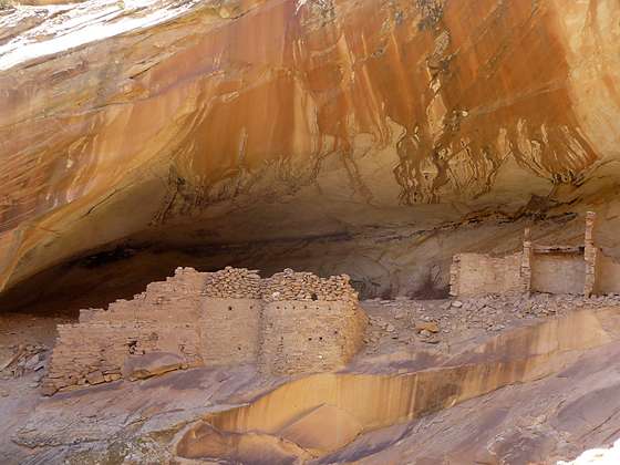
Close up of the ruins in Monarch Cave
This short, easy trail leads to an impressive ruin, situated in a deep, east facing alcove beneath a pour-off. The site includes an interesting structure with rounded walls along with rock art, pottery shards and grinding stones.
- Distance: 1.6 miles (RT)
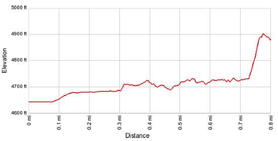
- Elevation: 4,650-ft. at Trailhead
Maximum elevation - 4,810-ft. - Elevation Gain: 160-ft.
- Difficulty: easy
- Basecamp: Bluff / Bears Ears NM
- Region: Southeast Utah
Trail Description - Monarch Cave
Comb Ridge is a stunning sandstone ridge of steeply tilted rock layers called a Monocline, a step-like fold in the rock strata. The ridge runs north-south for approximately 80 miles from Utah’s Abajo Mountain to Kayenta, Arizona. The jagged appearance of the ridge is similar to a rooster’s comb, hence the logic behind its name.
The Lower Butler Wash Road, which parallels the base of the ridge to the east, offers access to the ridge and its drainages which are renowned for the numerous prehistoric sites, including ruins and rock art. Monarch Cave is one of my favorite sites.
The biggest challenge when exploring the sites along Butler Wash is finding the correct trailhead. There are no signs marking turnoffs to the various drainages. The best bet is to religiously keep track of your mileage as you progress up or down the road. (See the driving directions below for more information.)
The boot beaten path to Monarch Cave starts on the southwest side of the trailhead parking area (see driving directions below). Follow the trail as it drops steeply down a sandy slope into Butler Wash. Here an obvious trail heads west, cuts across the wash and then climbs the bench to the right (north) of the mouth of a narrow east-west trending canyon about 0.1 miles from the trailhead.
The pack sand trail, marked with occasional rock cairns, cuts across the corner of the bench and soon drops into the canyon. This detour over the bench shortcuts a meander and avoids the thick vegetation at the mouth of the canyon.
Back in the canyon the boot-beaten path heads west up the pleasant drainage, traveling through scrub growth and cottonwoods. Along the way you will pass an alcove high on the canyon’s north wall.
After hiking about three-quarters of the mile the trail splits. Ahead views open to impressive ruins tucked in good size alcove beneath a pour-off. Cottonwoods and thick vegetation grow around an unseen plunge pool at the base of the pour-off.
At the split take the right fork that climbs a slickrock slope toward the ruin. As you ascend enjoy ever improving views of the distinctive ruins. The facade of the ruin’s largest remaining structure, which runs across the front of the alcove, includes curved walls with portholes. Other structures are located along the alcove’s back walls.
Your route will traverse a slickrock ledge beneath a narrow overhang. Hand prints, pictographs of human figures and abstract elements and petroglyphs decorate the walls beneath the overhang. As you traverse the ledge be careful not to step in the metate grooves worn into a section of the slickrock ledge.
Before you reach the ruins the ledge ends at a steep slickrock slope. Here a chain blocks further progress along the ledge. Please respect this closure. The ledge offers great vantage points for appreciating the ruins. Binoculars will help you see into the alcove. The soot stained ceiling along the back of the alcove offers an indication of the size of the ruin.
Returning back to the intersection, the left fork leads past the trash midden, cordoned off with chains, and climbs up the south side of the canyon, traveling through dense vegetation that contains poison ivy. Tread carefully if you choose to explore in this direction.
In order to reach the alcove hikers will need to cross a narrow bench with loose scree and some exposure. If in doubt, turn around. One of the ruins in the alcove still has a section of intact roof with thatch and wood poles. The construction of the walls along the curves section of the ruin is also quite interesting. If you peer over the edge of the alcove you will be able to see the plunge pool, surrounded by dense vegetation, at the base of the pour-off. Use care when walking around the alcove. Don’t touch any of walls, some of which are quite precariously built along the edge of the alcove's steep drop off.
When visiting Monarch Cave please treat all the archaeology you discover with reverence and respect so that it may be enjoyed by future generations. Do not sit, climb or step on the walls of any structures or attempt to enter the structures. Leave any pot shards, corn cobs or other relics where you found them. Remember that rock art is extremely fragile and easily damaged. Never touch rock panels as the oil on your fingers can speed the erosion of the rock art. Do not vandalize the panels by taking latex mold prints or rubbings from rock art or adding modern additions. Please see the Tips for Enjoying and Preserving Archaeology Sites for more information.
When you are done exploring the ruins retrace your steps to the trailhead for a 1.6 mile round-trip hike.
Note: There is a turnoff on the Lowe Butler Wash Road at 7.1 miles. If you mistakenly park at this spot you can still reach Monarch Cave. From the parking area, drop down to and cross Butler Wash, following one of the many paths through the dense vegetation. Turn right (north) on the west side of the wash and walk up the wash for a tenth of a mile. When you reach the mouth of an east-west trending canyon, look for the trail to Monarch Cave heading up the bench on the north side of the canyon. From this point follow the directions as outline above.
Elevation Profile
Driving Directions
The surface of Utah County Road 262, the Lower Butler Wash Road, is packed dirt with sections of slickrock. The road can be rutted, sandy and rough in places. Under good conditions the road is passable with a 2WD vehicle if driven carefully. High clearance or 4WD is better.
From Bluff: Drive southwest on US-191 S for 4.2 miles. Where US-191 turns south continue straight ahead on US 162 for 0.9 miles and turn right on County Road 262 / Lower Butler Wash Road. The road is located between mile posts 41 and 40 and is across from the Bluff Airport Road (County Road 269A). Almost immediately reach a gate across the road, secured by a chain. Make sure you close the gate after passing through. Drive 7.2 miles north and turn left onto a spur road [~GPS location: 37.359050, -109.629731]. In a short distance arrive at a parking area. Note there is also a turn off at 7.1 miles.
You have passed the turn off if the Lower Butler Wash Road starts curving to the right (northeast).
From Mexican Hat: Drive east on US-163 for 19.6 miles and turn left on County Road 262 / Lower Butler Wash Road. The road is located between mile posts 41 and 40 and is across from the Bluff Airport Road (County Road 269A). Almost immediately reach a gate across the road, secured by a chain. Make sure you close the gate after passing through. Drive 7.2 miles north and turn left onto a spur road [~GPS location: 37.359050, -109.629731]. In a short distance arrive at a parking area. Note there is also a turn off at 7.1 miles.
You have passed the turn off if the Lower Butler Wash Road starts curving to the right (northeast).
Trail Resources
- Trail Photo Gallery
- Trail Maps
- Basecamp(s) Information: Bluff / Bears Ears NM
- Region Information: Southeast Utah
- Other Hiking Regions in: Utah