Split Level Ruins
Two alcoves, stacked one atop of the other, harbor interesting ruins and rock art in a canyon off the Lower Butler Wash Road.
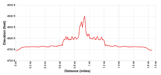
- Distance: 1.8 miles (RT)
- Elevation: 4,750-ft. at Trailhead
Maximum elevation - 4,900-ft. - Elevation Gain: 150-ft.
- Difficulty: easy
- Basecamp: Bluff / Bears Ears NM
- Region: Southeast Utah
Trail Description - Split Level Ruin
Comb Ridge is a stunning sandstone ridge of steeply tilted rock layers called a Monocline, a step-like fold in the rock strata. The ridge runs north-south for approximately 80 miles from Utah’s Abajo Mountain to Kayenta, Arizona. The jagged appearance of the ridge is similar to a rooster’s comb, hence the name.
The Lower Butler Wash Road, paralleling the base of the ridge to the east, offers access to the ridge and its drainages renowned for prehistoric sites, including ruins and rock art. Split Level Ruins is highly recommended stop along the road.
The biggest challenge when visiting the sites along Butler Wash is finding the correct trailhead. There are no signs marking turnoffs to the various drainages. When looking for trailheads your best bet is to religiously keep track of your mileage as you progress up or down the road. (See the driving directions below for more information.)
At the northwest end of the trailhead parking area for Split Level Ruins find a wide dirt track that heads west toward Butler Wash. As you approach the wash pass brown mylar stakes blocking the road to vehicular traffic.
Cross Butler Wash and then follow an old two-track dirt road heading west through scrub growth. Ahead are fine views of Comb Ridge.
At 0.4 miles follow the two-track as it curves to the right, just before reaching a cluster of cottonwoods. A brown mylar stake marks the turn. Two more mylar stakes mark where the trail crosses a wash. The first indicating where the trail drops down into the wash and the second showing where the trail climbs out of the wash
The path now heads west atop a small plateau above the north side of a canyon. At 0.5 miles the trail drops down into the canyon’s wash. Make note of this location for the return trip, it is easy to miss. This little detour circumvents the mouth of the canyon which is clogged with dense brush.
Follow the trail has it head southwest for about 200-ft. to “Y” intersection. This is the junction of two canyons. Bear right, staying on the boot beaten path traveling above the wash. You are now heading west/northwest up the canyon harboring Split Level Ruins.
At 0.7 miles reach an interesting alcove/undercut where the canyon curves to the left. Here you will find two white hand prints and faded red hand prints. Nearby are rocks used for grinding, some decorated with petroglyphs. Across the canyon is a step/ladder-like structure leading up to an empty alcove. (Please don’t use the steps. Instead access the alcove from the sides.)
When visiting the ruins in Split Level canyon please treat all the archaeology you discover with reverence and respect so that it may be enjoyed by future generations. Do not sit, climb or step on the walls of any structures or attempt to enter the structures. Leave any pot shards, corn cobs or other relics where you found them. Remember that rock art is extremely fragile and easily damaged. Never touch rock panels as the oil on your fingers can speed the erosion of the rock art. Do not vandalize the panels by taking latex mold prints or rubbings from rock art or adding modern additions. Please see the Tips for Enjoying and Preserving Archaeology Sites for more information.
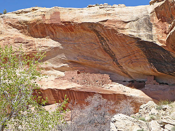
Views open to Split Level Ruins at 0.8 miles. The ruins are located in two alcoves stacked atop one another. Initially you will see the ruins located in the upper alcove, which is inaccessible. Soon the structures in the lower alcove come into view.
As you approach the ruin take the trail that travels along the cliff face on the right (north) side of the canyon. Watch for petroglyphs along the cliff wall. As you get closer to the ruins look up at the upper alcove to see three fascinating green and white circular pictographs along the alcove’s back wall (to the left of the ruins).
The boot beaten path soon curves into the lower alcove, passing behind a few large boulders and then emerges into the main part of the alcove. Here you will find ruins in various states of decay, grinding stones and faded petroglyphs/pictographs. Notice how the large boulders were incorporated into a few of the structures at the site. Also of note is one interesting rock art panel that includes red hand prints and petroglyphs of a hand with very long fingers.
When you are done investigating the site retrace your steps to the trailhead for a 1.9 mile round trip hike.
Elevation Profile
Driving Directions
The surface of Utah County Road 262, the Butler Wash Road, is packed dirt with sections of slickrock. The road can be rutted, sandy and rough in place. Under good conditions the road is passable with a 2WD vehicle if driven carefully. High clearance or 4WD is better.
From Bluff: Drive southwest on US-191 S for 4.2 miles. Where US-191 turns south continue straight ahead on US 162 for 0.9 miles and turn right on County Road 262 / Lower Butler Wash Road. The road is located between mile posts 41 and 40 and is across from the Bluff Airport Road (County Road 269A). Almost immediately reach a gate across the road, secured by a chain. Make sure you close the gate after passing through. Drive 8.3 miles to the fork in the road and bear left. At 9.6 miles reach a spur road on the left [~GPS location: 37.388846, -109.624371]. Turn left onto the spur and drive a short distance to a parking area. There is a second spur in the road to the left at 9.7 miles [~GPS location: 37.389652, -109.624219]. This road also leads to the parking area. If you reach a second “Y” intersection on the Butler Wash Road (at 10.0 miles) you have gone too far. Turn around, drive back 0.3 miles and turn right to find the trailhead for Split Level Ruin.
From Mexican Hat: Drive east on US-163 for 19.6 miles and turn left on County Road 262 / Lower Butler Wash Road. The road is located between mile posts 41 and 40 and is across from the Bluff Airport Road (County Road 269A). Almost immediately reach a gate across the road, secured by a chain. Make sure you close the gate after passing through. Drive 8.3 miles to the fork in the road and bear left. At 9.6 miles reach a spur road on the left [~GPS location: 37.388846, -109.624371]. Turn left onto the spur and drive a short distance to a parking area. There is a second spur in the road to the left at 9.7 miles [~GPS location: 37.389652, -109.624219]. This road also leads to the parking area. If you reach a second “Y” intersection on the Butler Wash Road (at 10.0 miles) you have gone too far. Turn around, drive back 0.3 miles and turn right to find the trailhead for Split Level Ruin.
Trail Resources
- Trail Photo Gallery
- Trail Maps
- Basecamp(s) Information: Bluff / Bears Ears NM
- Region Information: Southeast Utah
- Other Hiking Regions in: Utah