Cave Spring 
Distance: 0.6 miles
Needles District, Canyonlands National Park, near Canyonlands in Southeast Utah
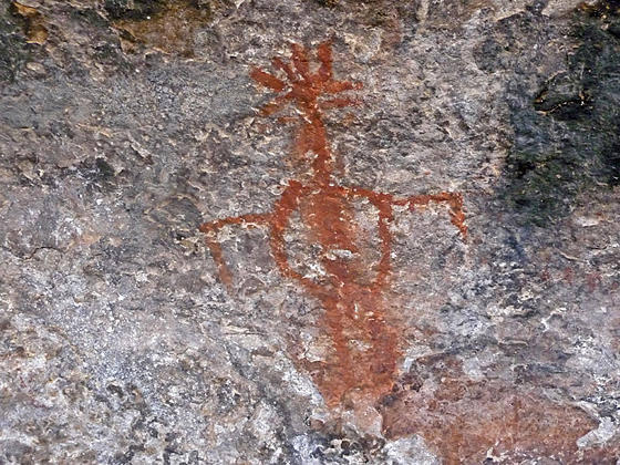
Pictograph
This short, entertaining hike visits an old cowboy camp and the Cave Spring alcove, harboring a spring and pictographs. Beyond the alcove the trail climbs atop a slickrock formation with fine views of nearby rock formation. Distant views stretch to the Abajo and La Sal Mountains.
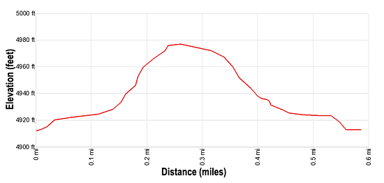
- Distance: 0.6 miles (Loop)
- Elevation: 4,910-ft. at Trailhead
Maximum elevation - 4,975-ft. - Elevation Gain: 65-ft.
- Difficulty: easy
- Basecamp: Canyonlands / Monticello
- Region: Southeast Utah
Trail Description - Cave Spring
The Cave Springs trailhead is located on the left (west) side of the trailhead parking area (see driving directions below). The trail heads west and quickly reaches a “Y” intersection. Turn left and walk the loop in a clockwise direction. In approximately 200-ft. reach a fenced alcove on your right. Here you will see the remnants of a cowboy camp. The alcove houses an old stove, tables, benches, tin bowls and cooking gear, rusted cans and other relics.
Isolated camps like this were used by cowboys employ by ranchers from the 1890’s until 1975, when cattle ranching was discontinued inside Canyonlands National Park. Evidence indicates the camp was first used by Ancestral Puebloan Indians. Nearby year-round water sources made this an excellent place for a campsite for both the Ancestral Puebloans and the cowboys.
After viewing the Cowboy Camp the trail curves to the right, passes beneath an overhang and soon reaches the Cave Spring Alcove where you will find a spring along the back wall. Several red pictographs and a panel of handprints are located on the walls near the spring. Please don’t disturb the spring, it is used by wildlife.
Beyond Cave Spring the trail soon reaches a wood ladder that climbs the cliff to a slickrock bench. Follow the bench for a short distance to a second ladder that ascends to the top of the slickrock formation. Rock cairns now mark the trail at it travels west along the slickrock and then curves to the north. Along the way enjoy with fine views of nearby rock formations in Canyonlands. In the distance are nice views of the Abajo Mountains and Six Shooter Peak. On a clear day you can see the La Sal Mountains to the northeast.
At 0.3 miles the trail descends the slickrock to the sagebrush flats and then turns right (east), passing beneath a few alcoves with interesting formations along the back walls. At 0.6 miles reach the end of the loop and the parking area.
Elevation Profile
Driving Directions
From Moab: Drive south on U.S. Highway 191 for roughly 40 miles to Utah Highway 211 (signed for Canyonlands National Park, Needles District) and turn right (west). Follow Utah Highway 211 west for 35.1 miles and turn left onto to the road signed for Salt Creek and Cave Springs. (This is the first road to the left after passing the Visitor Center and Road Side Ruin.) Drive 0.7 miles and turn left onto the Cave Spring Road. Follow the road for 1.0 mile to the Cave Springs trailhead parking area at the end of the road. The trailhead is on the left.
From Monticello: Drive north on U.S. Highway 191 for roughly 14.3 miles to Utah Highway 211 (signed for Canyonlands National Park, Needles District) and turn left (west). Follow Utah Highway 211 west for 35.1 miles and turn left onto to the road signed for Salt Creek and Cave Springs. (This is the first road to the left after passing the Visitor Center and Road Side Ruin.) Drive 0.7 miles and turn left onto the Cave Spring Road. Follow the road for 1.0 mile to the Cave Springs trailhead parking area at the end of the road. The trailhead is on the left.
From Blanding, UT: Drive north on U.S. Highway 191 for roughly 34.8 miles to Utah Highway 211 (signed for Canyonlands National Park, Needles District) and turn left (west). Follow Utah Highway 211 west for 35.1 miles and turn left onto to the road signed for Salt Creek and Cave Springs. (This is the first road to the left after passing the Visitor Center and Road Side Ruin.) Drive 0.7 miles and turn left onto the Cave Spring Road. Follow the road for 1.0 mile to the Cave Springs trailhead parking area at the end of the road. The trailhead is on the left.
Trail Resources
- Trail Photo Gallery
- Trail Maps
- Basecamp(s) Information: Canyonlands / Monticello
- Region Information: Southeast Utah
- Other Hiking Regions in: Utah