Details: Lost Canyon/Big Spring Canyon Loop 
Distance: 8.7 - 10.5 miles (loop)
Needles District, Canyonlands National Park, near Canyonlands in Southeast Utah
Hike Facts
- Distance: 8.7 - 10.5 miles (loop)
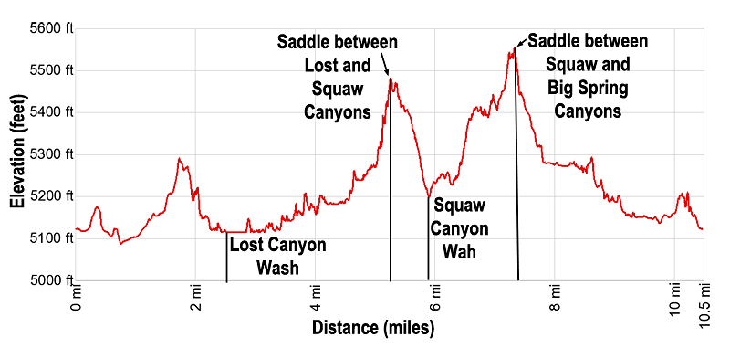
- Elevation: 5,122-ft. - 5,584-ft.
- Elevation Gain: 1,160-ft.
- Difficulty: strenuous
- Trail Highlights: See Trail Intro
- Basecamp(s): Canyonlands
- Region: Southeast Utah
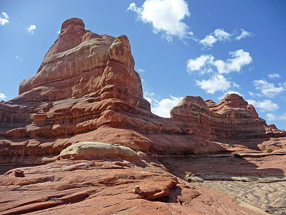
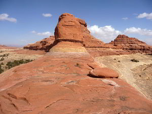
Spectacular canyon scenery awaits hikers on this varied loop hike traversing sandy washes, climbing slickrock benches and crossing steep sandstone ridges as it travels through three scenic canyons.
Trailhead to Squaw Canyon
Distance from Trailhead: 8.7 miles (loop)
Ending/Highest Elevation: 5,500-ft.
Elevation Gain: 378-ft.
The Squaw Flat trailhead is located along the south side of the Squaw Flat Campground Loop “A” road. From the trailhead, walk south for 200-ft. to a trail junction. To the left is the trail to Squaw Canyon, Lost Canyon and Peekaboo Springs. To the right is the path to Big Spring Canyon. The loop can be done in either direction. I describe the loop in a clockwise direction, going up Lost Canyon and returning via Big Spring Canyon. The route between the two canyons climbs steep grades into and out of the upper end of Squaw Canyon.
To walk the loop in the clockwise direction turn left (southeast) at the junction in the direction of Squaw and Lost Canyons. The trail travels across flat, scrub covered desert terrain for 0.2 miles to a low sandstone ridge. Rock cairns mark the trail crossing the ridge. At the top of the ridge enjoy nice views of the slickrock formations rising to the north of the campground and the La Sal Mountains to the northeast.
Beyond the ridge the trail continues across the scrub covered desert scattered with junipers to the junction with the Squaw Canyon trail, branching to the right, one mile from the trailhead. Take the left fork toward Lost Canyon and Peekaboo Springs.
Past the junction the trail follows a gently ascending traverse across scrub flats before arriving at a second sandstone ridge at 1.6 miles. Rock cairns mark the short, steep climb to the top of the ridge where views open in all directions to a world of colorful sandstone formations.
The cairned trail now curves to the left (east/southeast) as it descends along the ridge’s slickrock slopes to the bottom of a minor unnamed canyon. A metal ladder aids a portion of the descent. Carefully follow the rock cairns along this section of the trail. When following cairns it is always best to look ahead and find the next cairn before proceeding.
In the canyon the trail travels along the wash for a short distance and then proceeds over scrub covered benches to the junction with the Lost Canyon Trail at 2.5 miles. Turn right (south/southwest) on the Lost Canyon trail. The Peekaboo trail continues straight ahead (southeast). (Note: Lost Canyon campsite #1 is located a short distance beyond the junction along the Peekaboo trail.)
The Lost Canyon trail gently ascends along the canyon bottom, frequently crossing the wash and climbing the adjacent benches to cutoff meanders in the canyon’s sinuous course. At 3.3 miles pass Lost Canyon campsite #2 on you right. An undercut along the western side of the wash near the campsite may contain a nice pool of water during the spring or after a rain storm.
As you continue hiking upstream the canyon narrows and becomes more vegetated. During the spring or after a rain storm you may pass pools of water and sections of running water in the wash. Occasionally obstacles in the wash or brushy sections along well watered sections of the canyon temporarily force the trail to climb high on the adjacent benches.
Just beyond Lost Canyon campsite #3, 4.4 miles from the trailhead, the trail enters a narrow, heavily vegetated side canyon. The path exits the wash at 4.9 miles, following a cairned trail that climbs steeply up ledges on the canyon’s north wall and then ascends steep slickrock slopes to a saddle on the sandstone ridge separating Lost and Squaw Canyons. Be sure to carefully follow the rock cairns. There are quite a few twists and turns on the lower section of the route climbing out of the canyon.
From the saddle enjoy the spectacular panoramas of colorful sandstone fins, spires and hoodoos towering above the deep canyons. On a clear day wonderful vistas extend to the northeast and northwest.
After soaking in the views continue on the trail as it heads right (north), descending moderately steep slickrock slopes into Squaw Canyon. The upper section of the trail enjoys great views of the multi-hued sandstone ridges to the south/southwest.
As you descend the trail drops off the ridge and climbs down a sandstone bench with scattered junipers growing amid small pockets of soil. Soon the trail enters a side canyon, descending a rocky trail with intermittent slickrock chutes to the Squaw Canyon wash at 5.9 miles. (During the spring months this section of the Squaw Canyon wash may contain water.) Just before reaching the wash the trail passes a spur trail to Squaw Canyon campsite #2.
Cross to the northwest side of the wash and a signed trail junction. Turn left (southwest) and head up Squaw Canyon. There is also a sign pointing in the same direction toward Druid Arch. The trail to the right goes down Squaw Canyon and back to the Squaw Flat campground in 2.8 miles. (If you are feeling hot and tired this is a good place to shorten the loop. Total distance for the shorter loop is 8.7 miles.)
Squaw Canyon to Big Spring Canyon
Distance from Trailhead: 10.5 miles (loop)
Ending/Highest Elevation: 5,584-ft.
Elevation Gain: 1,160-ft.
The trail up Squaw Canyon ascends on easy grades along the bench on the northwest side of the canyon. At 6.4 miles the climb steepens as the cairned trail ascends sandstone ledges to a rocky bench. Atop the bench the path heads west into a shallow side canyon. Rock cairns mark this section of the trail. From the bench enjoy great views of the sculpted, multi-hued sandstone formations towering above both sides of Squaw Canyon. A massive fin rises above the northwest end of the side canyon.
At 6.8 miles, near the head of the side canyon, the trail makes a sharp left turn and now travels east along the bench, emerging from the side canyon at 6.9 miles. Here fine views open northeast down Squaw Canyon to the La Sal Mountains.
After enjoy the views follow the path as it curves to the right (west) and enters a second side canyon, traveling along a slickrock bench above the north side of the canyon. A short distance beyond a short detour is required to circumvent a large crack/crevasse.
Beyond the crevasse reach the junction with a trail branching left (south) toward Elephant Canyon. Our trail toward Big Spring Canyon continues straight ahead, now ascending along slickrock slopes. Ahead a massive amphitheater soars above the head of the canyon.
Near the head of the canyon rock cairns mark a turn to the right. The path now ascends a slickrock drainage and then contours along slickrock slopes before the final short, steep climb to the saddle between Squaw and Big Spring Canyons at 7.3 miles.
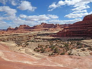
Views from this lofty spot encompass a stunning landscape of sculpted rock spires, monoliths and fins rising above sinuous canyons. To the south/southeast are superb views of Squaw Canyon. To the north views stretch across Big Spring Canyon to the formations in Chesler Park. Massive red rock mesas and Buttes, including Junction Butte and Grandview Point in the Island in the Sky district of Canyonlands National Park are seen in the distance. The huge amphitheaters and fins at the head the side canyon and Big Spring Canyon tower overhead.
From the saddle the trail descends into Big Spring Canyon, following a cairned route that leads steeply down slickrock slopes, over knobs and then down a chute. Some people are more comfortable butt scooting down the steep chute until the grade abates a bit. Be sure to turn around during the descent for great views of the rock formation rising above the head of the canyon.
Beyond the chute the path descends slickrock slopes on moderately-steep grades to a scrub covered bench studded with pinion pines and junipers. Here the grade briefly abates.
At 7.7 miles the path makes a short, steep descent into the Big Spring wash. Watch for rock cairns that soon lead out of the wash to trails traveling along the adjacent benches. As you descend the drainage widens and the grade soon abates.
At 8.1 miles the path curves to the right (northeast) as it continue descending Big Spring Canyon on easy grades, traveling along sandy, vegetated benches on the east side of the canyon. During the spring you may see some water in the wash. Along the way the path travels by some interesting freestanding mushroom shaped towers.
At 8.9 miles the trail passes Big Spring Campsite #2 on the left. Soon the canyon starts to widen and becomes noticeably drier. Reach a trail junction at 9.7 miles. Continue straight ahead on the trail to Squaw Flat. The path branching left (southwest) leads to Chesler Park and Druid Arch. A short distance beyond the junction a spur trail branching right goes to Big Spring Campsite #1.
Beyond the junction the path ascends a scrub covered bench and soon arrives at another trail junction at 10.0 miles. To the left is the trail to Squaw Flat Campground B. Turn right toward Squaw Flat Campground A. Follow the trail as it crosses a low sandstone ridge. Scenic views from the top of the ridge encompass the Needles to the southwest and the La Sal Mountains to the northeast.
The path drops off the ridge and then travels along a slickrock bench. A short, steep descent from the bench leads to a trail traveling across scrub covered flats back to the Squaw Flat trailhead at 10.5 miles.
Elevation Profile
Driving Directions
From Moab, UT: Drive south on U.S. Highway 191 for roughly 40 miles to Utah Highway 211 (signed for Canyonlands National Park, Needles District) and turn right (west). Follow Utah Highway 211 west for 37.2 miles and turn left (west), on the road signed for the Squaw Flat Campground. The turn is located 2.8 miles beyond the Visitor Center. At the first intersection (0.3 miles) continue straight ahead on the Campground Loop A road for 0.9 miles. (Do not turn right onto the Campground Loop B road.) The parking area for the Squaw Flat Trailhead is located on the left (south) side of the road.
From Monticello, UT: Drive north on U.S. Highway 191 for roughly 14.3 miles to Utah Highway 211 (signed for Canyonlands National Park, Needles District) and turn left (west). Follow Utah Highway 211 west for 37.2 miles and turn left (west), on the road signed for the Squaw Flat Campground. The turn is located 2.8 miles beyond the Visitor Center. At the first intersection (0.3 miles) continue straight ahead on the Campground Loop A road for 0.9 miles. (Do not turn right onto the Campground Loop B road.) The parking area for the Squaw Flat Trailhead is located on the left (south) side of the road.
From Blanding, UT: Drive north on U.S. Highway 191 for roughly 34.8 miles to Utah Highway 211 (signed for Canyonlands National Park, Needles District) and turn left (west). Follow Utah Highway 211 west for 37.2 miles and turn left (west), on the road signed for the Squaw Flat Campground. The turn is located 2.8 miles beyond the Visitor Center. At the first intersection (0.3 miles) continue straight ahead on the Campground Loop A road for 0.9 miles. (Do not turn right onto the Campground Loop B road.) The parking area for the Squaw Flat Trailhead is located on the left (south) side of the road.
Trail Resources
Trail Intro / Trail Photo Gallery / Trail Map
Basecamp(s) Information:
Canyonlands
Region Information:
Southeast Utah
Other Hiking Regions in:
Utah