Squaw Canyon to Big Spring Canyon Loop 
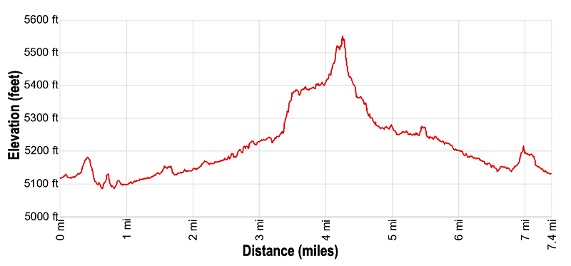
Distance: 7.4 miles
Needles District, Canyonlands National Park, near Canyonlands in Southeast Utah
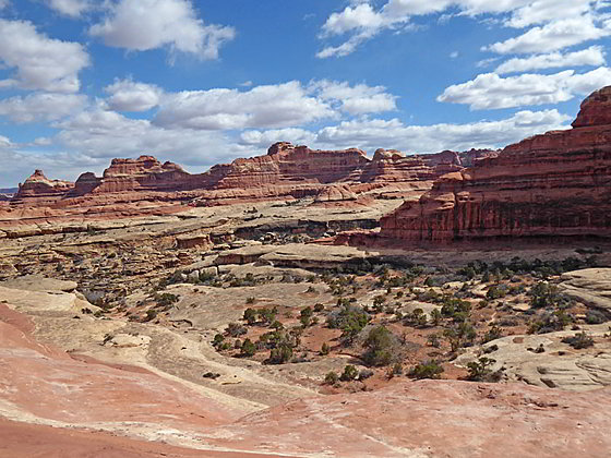
View on the climb to the saddle
This quintessential trail in the Needles District of Canyonlands National Park visits two scenic canyons linked by a high slickrock saddle featuring stunning views of a sandstone landscape of sculpted rock spires, monoliths and fins.
- Distance: 7.4 miles (RT)
- Elevation: 5,122-ft. at Trailhead
Maximum elevation - 5,550-ft. - Elevation Gain: 428-ft.
- Difficulty: moderate-strenuous
- Basecamp: Canyonlands / Monticello
- Region: Southeast Utah
Trail Description - Squaw Canyon to Big Spring Canyon Loop
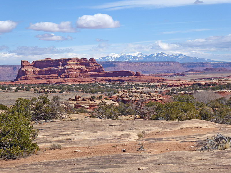
This hike is a great introduction to the Needles District of Canyonlands. The trail visits a magical landscape of multi-hued sandstone monoliths, rock spires, fins and knobs rising above two scenic canyons. From the saddle linking the canyons views stretch across the heart of Needles District to the La Sal Mountains and the massive red rock buttes and mesas to the Island in the Sky District.
Portions of this hike ascend steep slickrock slopes and traverse ledges with some minor exposure. Extreme caution is required when the slickrock is wet or icy. This trail is not recommended for people with a fear of heights or uncomfortable walking on steep slickrock friction pitches.
The trail is best done in the Spring and Fall when temperatures are milder. The hike is not recommended during the summer month when temperatures often exceed 100-degrees.
The Squaw Flat trailhead is located along the south side of the Squaw Flat Campground Loop “A” road. (See driving directions below.) From the trailhead walk 200-ft. south to a junction. To the left is the trail to Squaw Canyon, Lost Canyon and Peekaboo Springs. To the right is the path to Big Spring Canyon. The loop can be done in either direction. I describe the loop in a clockwise direction, going up Squaw Canyon and returning via Big Spring Canyon.
Turn left (southeast) at the junction toward Squaw Canyon. The packed dirt trail travels across flat, scrub covered desert terrain for 0.2 miles to a low sandstone ridge and then climbs over the ridge. Rock cairns make the trail crossing the ridge. At the top of the ridge enjoy nice views of the surrounding sandstone formations. The La Sal Mountains rise to the northeast.
Beyond the ridge the trail continues across the scrub-clad flats scattered with junipers to a junction at 1.1 miles. Here the trail to the left continues southeast toward Lost Canyon and Peekaboo Springs. We bear right (south/southwest) up Squaw Canyon, ascending on easy grades along the bench on the left (east) side of the wash.
At 1.7 miles the path crosses to the west side of the wash. Beyond this point the canyon narrows. As the trail ascends the canyon it crosses the wash several more times to avoid obstacles and cut off meanders. Along the way path passes Squaw Campsite #1 at 2.0 miles. Early in the season and after it rains there may be water along sections of the wash.
At 2.5 miles the trail rounds a bend and the canyon grows more scenic with colorful sandstone walls topped by knobs, fins and spires. Pass the junction with the trail branching left (south) toward Lost Canyon and the Squaw Campsite #2 at 2.8 miles. We continue straight ahead up Squaw Canyon, now ascending the bench above the west side of the wash.
At 3.2 miles the trail curves to the right and then soon turns to the left as it climbs steeply up ledges to a slickrock bench. Atop the bench the path heads west into a shallow side canyon. Rock cairns mark this section of the trail. From the bench enjoy great views of the sculpted, multi-hued sandstone formations towering above both sides of Squaw Canyon. A massive fin rises above the northwest end of the side canyon.
At 3.7 miles, near the head of the side canyon, the trail makes a sharp left turn and now travels east along the bench, emerging from the side canyon at 3.8 miles. Here fine views open northeast down Squaw Canyon to the La Sal Mountains.
After enjoy the views follow the path as it curves to the right (west) and enters a second side canyon and then travels along a slickrock bench above the north side of the canyon. A short distance beyond a short detour is required to circumvent a large crack/crevasse.
Beyond the crevasse reach the junction with a trail branching left (south) toward Elephant Canyon. Our trail toward Big Spring Canyon continues straight ahead, now ascending along slickrock slopes. Ahead a massive amphitheater soars above the head of the canyon.
Near the head of the canyon rock cairns mark a turn to the right. The path now ascends a slickrock drainage and then contours along slickrock slopes before the final short, steep climb to the saddle on the ridge between Squaw and Big Spring Canyons at 4.2 miles. This section of the trail requires friction pitch hiking with some mild exposure. (Good shoes with soles that grip are essential when hiking friction pitches up/down slickrock slopes.)
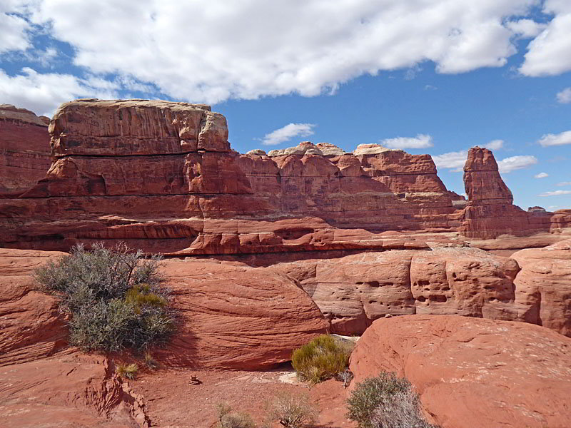
From the saddle enjoy superb views to the south/southeast of Squaw Canyon. To the north views stretch across Big Spring Canyon to the formations in Chesler Park. Junction Butte and Grandview Point in the Island in the Sky district of Canyonlands National Park are seen in the distance. The huge amphitheaters and fins at the head the side canyon and Big Spring Canyon tower overhead.
From the saddle, a cairned route leads steeply down slickrock slopes, over knobs and then down a chute. Some people are more comfortable butt scooting down the steep chute until the grade abates a bit. Be sure to turn around during the descent for great views of the rock formation rising above the head of the canyon.
Beyond the chute the path descends slickrock slopes on moderately-steep grades to a scrub covered bench studded with pinion pines and junipers. Here the grade briefly abates.
At 4.6 miles the path makes a short, steep descent into the Big Spring wash. The trail now descends the canyon on a trail that uses the wash and its adjacent benches. Pay attention to rock cairns marking this section of the trail to stay on track. As you descend the drainage widens and the grade soon abates.
At 5.0 miles the path curves to the right (northeast). The trail now descends Big Spring Canyon on easy grades, traveling along the sandy, vegetated benches on the east side of the canyon. During the spring you may see some water in the wash. Along the way the path passes some interesting freestanding mushroom shaped towers.
At 5.8 miles the trail passes Big Spring Campsite #2 on the left. Soon the canyon starts to widen and becomes noticeably drier. Reach a trail junction at 6.6 miles. Continue straight ahead toward Squaw Flat. (The trail branching left (southwest) leads to Chesler Park and Druid Arch.) A short distance beyond a spur trail to the right leads to Big Spring Campsite #1.
Beyond the junction the path ascends a scrub covered bench and soon arrives at another trail junction at 6.9 miles. To the left is the trail to Squaw Flat Campground B. Turn right toward Squaw Flat Campground A. Follow the trail as it crosses a low sandstone ridge. Scenic views atop the ridge encompass a sea of sandstone formations to the southwest and the La Sal Mountains to the northeast.
The path drops off the ridge and briefly travels along a slickrock bench. A short, steep descent from the bench then leads to a trail traveling across scrub covered flats back to the Squaw Flat trailhead at 7.4 miles.
Elevation Profile
Driving Directions
Driving Directions From Moab: Drive south on U.S. Highway 191 for roughly 40 miles to Utah Highway 211 (signed for Canyonlands National Park, Needles District) and turn right (west). Follow Utah Highway 211 west for 37.2 miles and turn left (west), on the road signed for the Squaw Flat Campground. The turn is located 2.8 miles beyond the Visitor Center. At the first intersection (0.3 miles) continue straight ahead on the Campground Loop A road for 0.9 miles. (Do not turn right onto the Campground Loop B Road.) The parking area for the Squaw Flat Trailhead is located on the left (south) side of the road.
Driving Directions From Monticello, UT: Drive north on U.S. Highway 191 for roughly 14.3 miles to Utah Highway 211 (signed for Canyonlands National Park, Needles District) and turn left (west). Follow Utah Highway 211 west for 37.2 miles and turn left (west), on the road signed for the Squaw Flat Campground. The turn is located 2.8 miles beyond the Visitor Center. At the first intersection (0.3 miles) continue straight ahead on the Campground Loop A road for 0.9 miles. (Do not turn right onto the Campground Loop B Road.) The parking area for the Squaw Flat Trailhead is located on the left (south) side of the road.
Driving Directions From Blanding, UT: Drive north on U.S. Highway 191 for roughly 34.8 miles to Utah Highway 211 (signed for Canyonlands National Park, Needles District) and turn left (west). Follow Utah Highway 211 west for 37.2 miles and turn left (west), on the road signed for the Squaw Flat Campground. The turn is located 2.8 miles beyond the Visitor Center. At the first intersection (0.3 miles) continue straight ahead on the Campground Loop A road for 0.9 miles. (Do not turn right onto the Campground Loop B Road.) The parking area for the Squaw Flat Trailhead is located on the left (south) side of the road.
Trail Resources
- Trail Photo Gallery
- Trail Maps
- Basecamp(s) Information: Canyonlands / Monticello
- Region Information: Southeast Utah
- Other Hiking Regions in: Utah