Government to Big Man Panel 
Distance: 9.4 miles (round trip)
Grand Gulch Primitive Area, BLM, Monticello, Utah office, near Grand Gulch in Southeast Utah
By: Diane Greer
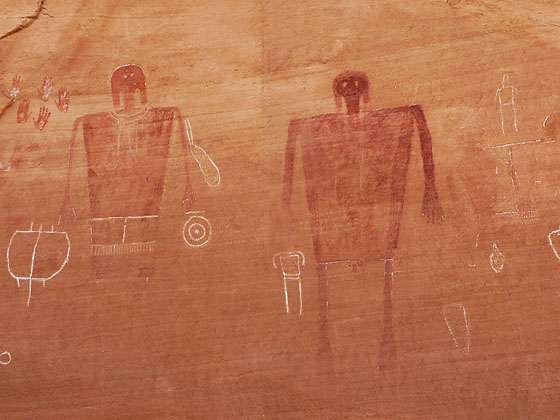
Big Man Panel
Two life-sized red and white pictographs, depicting a man and a woman, are the central focus of this fascinating rock art panel, located on a ledge high above Grand Gulch.
See Trail Detail/Full Description
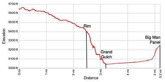
- Distance: 9.4 miles (round trip) to Big Man Panel
- Elevation: 5,650-ft. at Trailhead
5,050-ft. at Big Man Panel - Elevation Gain: -600-ft. to Big Man Panel
- Difficulty: moderate
- More Hikes in:
Grand Gulch / Bears Ears NM / Southeast Utah
Why Hike Government to Big Man Panel
This great hike leads to an amazing pictograph panel featuring two huge anthropomorphs (human-like figures), most likely a man and a woman, as well as other images. The trail travels along an old road on Cedar Mesa to the rim of Grand Gulch and then drops down to the canyon floor at Polly’s Island. In the canyon the trail heads north for 1.7 miles to a use trail that climbs steeply up the canyon’s east wall to the rock art panel.
The hike along the mesa enjoys great views of the Abajo Mountains and distant buttes to the north. From the rim fine views extend down into Grand Gulch and west across the canyon to Polly’s Island, where a small ruin is located just below the rim of this isolated sandstone butte rising in the middle of Grand Gulch.
The hike along the mesa is completely exposed, offering not shade from the hot sun or protection in the event of a lightning storm. Be sure to carry plenty of water. Before starting the hike check on current road conditions and water availability at the Kane Gulch Ranger Station.
Elevation Profile
Trail Resources
Trail Detail/Full Description / Trail Photo Gallery / Trail Map
Basecamp(s) Information:
Grand Gulch / Bears Ears NM
Region Information:
Southeast Utah
Other Hiking Regions in:
Utah