Details: Devils Staircase 
Distance: 8.0 - 14.0 miles (round trip)
Jedediah Smith Wilderness, Targhee National Forest, near Driggs in The Tetons
Hike Facts
- Distance: 8.0 - 14.0 miles (round trip)
- Elevation: 6,955-ft. - 9,700-ft.
- Elevation Gain: 2,105-ft. - 2,745-ft.
- Difficulty: moderate-strenuous
- Trail Highlights: See Trail Intro
- Basecamp(s): Driggs / Jackson Hole
- Region: The Tetons
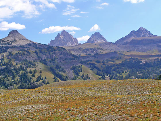
This trail on the west (back) side of the Teton Range climbs steeply to the scenic Teton Shelf with fine views of the granite cliffs towering above the shelf, the peaks rising above Alaska Basin and the summits of Grand, Middle and South Tetons.
Trailhead to Devils Staircase
Note: There are two trailheads at the South Teton Canyon parking lot, the Face Trail and the South Teton Trail #27. The Face Trail #029, located near the outhouse at the northeast end of the parking area, is signed as “Trail Not Maintained, Very Steep, Not Recommended.” We want the South Teton Trail, the broad trail on the east side of the parking area signed for the Devil’s Stairs, Alaska Basin and other destinations. See the driving directions (below) for more information.
The South Teton trail to the Devil’s Staircase heads southeast through forest and meadows on easy grades along an old Jeep road. As you head up the canyon a 10,000-ft. granite ridge dominates the views to the southwest.
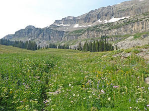
At 0.7 miles the trail crosses a good wood bridge to the west side of the South Fork of Teton Creek. Beyond the bridge the trail continues ascending on easy grades through trees and large meadows with nice views of the granite cliffs rising above both sides of the valley. In season the meadows are awash with wildflowers.
The trail now curves to the right, heading south up the canyon. A large brushy meadow, starting at 1.5 miles, offers nice views of the Wedge, a distinctive formation towering above the Teton Shelf, and Mount Jedediah Smith to the south. Look up to see interesting crags jutting from the cliffs above the trail to the west at 2.0 miles.
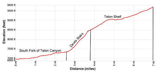
Reach the junction with the Devil’s Staircase Trail branching right at 2.7 miles. The South Teton trail continues straight ahead toward Alaska Basin (5.0 miles). We turn right on the Devil’s Staircase trail. The trail now climbs very steep switchbacks through meadows and scattered trees to the Teton Shelf, gaining over 1,000-ft in a mile. Near the top of the climb views open to the summit of Buck Mountain (11,838-ft,) rising to the southeast.
The grade abates at 3.7 miles. A brief stroll along a narrow shelf leads to a short ascent to the Teton Shelf (8,530-ft.) at 3.8 miles. Sheer granite cliffs tower 1,500-2,000-ft. above the broad grassy bench. At the head of the South Fork Canyon a massive cirque rims Alaska Basin. Mount Buck anchors the cirque, flanked by Peak 11,094 to the west. The Wall and Veil Peak rise above the cirque’s northern ridge. Mount Wister rises beyond Veil Peak. The summit of Battleship Mountain rises to the northeast
Almost immediately pass a use trail branching right. This spur trail leads to a small tarn along the base of the cliffs, a good place to get water. We continue straight ahead along the Devil’s Staircase trail that now ascends along the bench on moderate grades. During late July and early August the meadows along the bench sport an amazing display of wildflowers. The dramatic cliffs above the trail make the perfect backdrop for the lovely meadows.
Views of the Teton Range expand and evolve as you head south and then southeast along the shelf. At 4.6 miles Battleship Mountain rises across the valley to the east. The distinctive profiles of the summits of Grand Teton, Middle Teton and South Teton tower above the ridge extending south from Hurricane Pass. Nearer-at-hand, views of the Wedge continue to improve.
Cross a small stream fed by snowmelt from the cliffs above the trail at 5.0 miles. The trail now traverses a rolling landscape to the left (east) of a stream running along the base of the cliffs. At 5.4 miles the trail resumes its climb on moderate grades, reaching the junction with the Teton Crest Trail (9,700-ft.) at 6.95 miles. Total elevation gain for the full 14 mile round-trip hike is 2,745-ft.
Here Mount Meeks rises above the south end of the ridge above the Teton Shelf. Grand, Middle and South Tetons rise to the northeast beyond Alaska Basin’s cirques. Views extend northwest down the length of the Teton Shelf. To the right the Teton Crest trail heads southwest toward Mount Meek Pass and the Devil’s Canyon Shelf. To the left the Teton Crest trail drops down the Sheep Steps to Alaska Basin in 2.0 miles. From Alaska Basin it is 7.6 miles back to the South Fork trailhead.
Walk as far as time and energy permit along the Teton Shelf trail and then roam off the trail to an overlook to enjoy a picnic lunch and take in the views. Retrace your steps back to the trailhead after taking in the views. Some well-conditioned hikers turn the out-and-back hike into the loop by taking the Teton Crest trail to Alaska Basin and then returning via the South Teton Canyon Trail. The total length of this hike is 16.6 miles, beyond the reach of most day hikers.
My preference is to hike 1.2 to 2.2 miles out on the Teton Shelf and then turn around and hike back for a total round-trip hike of 10.0- to 12.0-miles. The loop option returning via the South Teton Canyon trail is beautiful but the views along the shelf trail are better. Keep an eye out for wildlife along the trail. I have been lucky enough to see a moose grazing in the brushy meadows.
Elevation Profile
Driving Directions
From Driggs, ID: At the only traffic light in Driggs, located at the corner of Main Street (ID-33) and E. Little Avenue, turn east onto E. Little Avenue toward the Grand Targhee Ski area. Follow the road, which becomes Ski Hill Road and passes through Alta, WY, for 6.1 miles and turn right on Teton Canyon Road. (The road is signed for the Treasure Mountain/Teton Canyon campgrounds.) Drive 4.6 miles on Teton Canyon Road and park at the South Teton Trailhead, the second trailhead parking area. (The first parking area is for the North Teton Creek to Table Mountain.) The trailhead is located on the east side of the parking lot.
From Jackson, WY: Head south/southwest through Jackson on US 191 S / US 26 W. At the southwest end of town turn right on WY-22 W. (A large Albertson’s Supermarket is located on the southeast corner of the intersection.) Follow WY-22 W for 31.3 miles to Driggs, ID. The route will cross Teton Pass and entering Idaho, where the road becomes ID-33 and pass through Victor.
At the only traffic light in Driggs, located at the corner of Main Street (ID-33) and E. Little Avenue, turn east onto E. Little Avenue toward the Grand Targhee Ski area. Follow the road, which becomes Ski Hill Road and passes through Alta, WY, for 6.1 miles and turn right on Teton Canyon Road. (The road is signed for the Treasure Mountain/Teton Canyon campgrounds.) Drive 4.6 miles on Teton Canyon Road and park at the South Teton Trailhead, the second trailhead parking area. (The first parking area is for the North Teton Creek to Table Mountain.) The trailhead is located on the east side of the parking lot.
Trail Resources
Trail Intro / Trail Photo Gallery / Trail Map
Basecamp(s) Information:
Driggs / Jackson Hole
Region Information:
The Tetons
Other Hiking Regions in:
Wyoming