Details: Death Canyon 
Distance: 7.8 - 12.0 miles (round trip)
Grand Teton National Park, near Grand Teton NP in The Tetons
Hike Facts
- Distance: 7.8 - 12.0 miles (round trip)
- Elevation: 6,780-ft. - 8,290-ft.
- Elevation Gain: 1,060-ft. - 2,010-ft.
- Difficulty: moderate-strenuous
- Trail Highlights: See Trail Intro
- Basecamp(s): Grand Teton NP / Jackson Hole
- Region: The Tetons
This beautiful hike up a dramatic canyon leads to the pretty, wildflower-filled meadows of the upper canyon set beneath rugged peaks. Extend the hike by walking to a viewpoint with vistas extending to the cliffs of Death Canyon Shelf and Mount Bannon.
Trailhead to the Meadows beyond the Patrol Cabin
Distance from Trailhead: 7.8 miles (round trip)
Ending/Highest Elevation: 7,840-ft.
Elevation Gain: 1,560-ft.
The Death Canyon Trail starts at the northwest end of the trailhead parking area (see directions below) and ascends northwest, passing a junction with the Valley Trail branching right. The path soon curves to the left (west) continuing its ascent on moderate grades through trees and intermittent meadows to the Phelps Lake Overlook (7,200-ft.) at 1.0 mile. The overlook is set atop a moraine created by the retreating Death Canyon Glacier, which once extended into the valley below. Here views stretch southeast across Phelps Lake to the Gros Ventre Range.
Beyond the overlook the path descends on moderately steep switchbacks through meadows and scattered trees with nice views of Prospectors Mountain rising to the west, Phelps Lakes and the peaks of the Gros Ventre. Soon the cliffs rising above the mouth of Death Canyon join the scene.
At 1.5 miles the grade abates as the path travels along talus slopes. Soon views open to a waterfall spilling down the slopes above the trail. Reach the junction with Valley Trail, branching left, at 1.7 miles. (The Valley Trail drops down to the path circling Phelps Lake in 0.15 miles after losing about 120-ft.) We continue straight ahead on the Death Canyon trail.
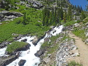
Past the junction the descent resumes on moderate grades. Soon the path enters the trees at the mouth of Death Canyon, reaching the lower point of the trail at 1.9 miles. The path now curves to the northwest, ascending on moderate grades through trees and dense shrubs along the north side of Death Canyon Creek. Openings offer views of the rugged walls rising above the narrow canyon.
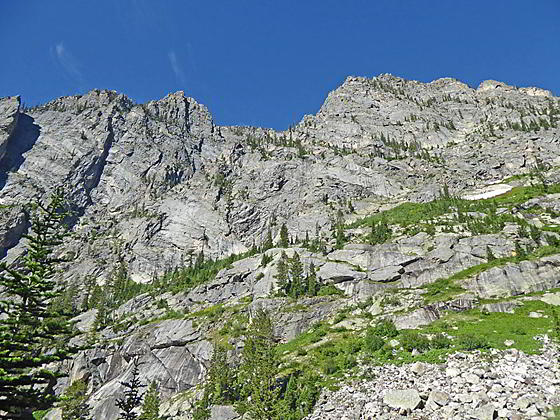
The grade steepens as the path switchbacks up rugged talus slopes high above the creek. Pockets of low-lying shrubs and groves of conifers grow along the canyon’s rugged slopes. To the south are terrific views of the rugged north facing cliffs of Prospectors Mountain. The roaring torrent of Death Canyon Creek spills down the canyon floor below the trail. As you gain elevation views open east to Sheep Mountain in the Gros Ventre.
At 3.2 miles the canyon constricts and the trail now climbs switchbacks near the raging creek. The canyon’s steep walls soar above the trail. At 3.7 miles the grade abates as the path reaches the upper canyon. Here views open to the rugged crags of peak 11094 rising along the canyon’s north wall.
The trail now ascends gently along the valley floor, traveling through groves of conifers and a small meadow along the northeast side of the Death Canyon Creek. Reach the Death Canyon Patrol Cabin and a junction at 3.9 miles. The log structure, set in a grove of conifers, was erected in 1935 by the Civilian Conservation Corps and turned into a ranger patrol cabin in 1945. The cabin is now listed on the National Register of Historic Places.
Many books including hikes up Death Canyon list the Patrol Canyon as a good turnaround point for day hikers. I strongly recommend continuing up Death Canyon for a short distance beyond the cabin to see the beautiful meadows and view the high peaks of the upper canyon before turning around.
At the junction by the Patrol Cabin, the Alaska Basin Trail to Static Peak Divide branches right (north). We continue straight ahead (northwest) up the Death Canyon trail. The path soon emerges from the trees into gorgeous, wildflower filled meadows surrounded by the rugged peaks rimming the canyon. The creek, lined with willow thickets, meanders down the canyon floor.
At 4.2 miles the trail curves to the left (west), travels through scattered trees and meadows along the north side of the creek. Open areas around the creek offers great views of the surrounding peaks. Ahead views soon open to Mount Bannon towering above Death Canyon Shelf at the head of the canyon.
The meadows end at 4.6 miles where the trail curves to the left (southwest) and crosses a wood bridge over a braided section of the creek. This is a good turn around point for day hikers, resulting in a 9.2 miles round-trip hike.
Viewpoint
Distance from Trailhead: 12.0 miles (round trip)
Ending/Highest Elevation: 8,290-ft.
Elevation Gain: 2,010-ft.
Day hikers with the time, energy and good weather will want to continue up the canyon. Be aware that over the next mile the trail travels through trees with limited views. It is not until the 5.6 mile point that the trees thin and then give way to meadows with great views of the Death Canyon Shelf area.
Past the bridge the trail continues on easy grades to a second crossing at 4.7 miles to the south side of the valley. Here the path curves to the right (west). After a short steep climb the grade abates a bit as the undulating path ascends through trees to the beginning of the Death Canyon camping zone at 4.9 miles. A short distance beyond openings briefly offer views of the rugged canyon walls before the trees close in again.
The path now ascends on variable grades before a short, steep descent leads to a crossing of a tributary at 5.3 miles. Past the crossing the trail climbs atop a knoll at 5.5 miles where views open to the crags rising to the north. A short descent from the knoll leads to a wood bridge crossing back to the north side of Death Canyon at 5.6 miles.
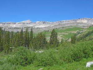
On the north side of the valley the trail ascends on moderate grades. Soon the trees thin and give way to meadows. Views open to the cliffs below Death Canyon Shelf at 5.9 miles. The valley bottom is filled with willows that obstruct the best views. I recommend climbing a short distance (about 0.1 miles) above the north side of the trail and finding a nice perch atop a rock to take in the views at the head of the canyon.
Here you will be able to see the cliffs rising above Death Canyon Shelf. The summit of Mount Bannon rises above the cliffs. To the south Prospectors Mountain and unnamed summits rim the canyon’s south wall. Rugged crags jut from the slopes above the trail to the north.
Day hikers should turn around at the viewpoint and retrace their steps to the trailhead for a 12.0 miles hike. Beyond the overlook the Death Canyon trail continues its ascent up the canyon. The path soon curves to the left (southwest) and then climbs to Fox Creek Pass, located at the south end of Death Canyon Shelf, at 9.7 miles. Here the Death Canyon Trail connects with the popular Teton Crest Trail.
Elevation Profile

Driving Directions
From Jackson: From the corner of W. Broadway and Cache Streets, at the southwest corner of the Jackson Town Square, head north on N Cache Street (US 191 N/US 89 N/ US 26 E) for 12.3 miles and then turn left onto Teton Park Road. Drive 0.7 miles on Teton Park Road and turn left onto the Moose Wilson Road. This narrow, twisty, curvy road is initially paved and then turns to dirt. Follow the Moose Wilson Road for 3.1 miles and the turn right onto the Whitegrass Ranch Road, signed for the Death Canyon Trailhead. This narrow paved road soon turns to dirt. Drive 1.6 miles to the end of the road and the Death Canyon Trailhead.
The dirt portion of the Whitegrass Ranch Road deteriorates as you near the trailhead, becoming more rutted and potholed. Hikers in low-clearance, 2WD vehicles will find a number of pull outs along the access road to park so as to avoid the worst of the ruts.
The Death Canyon trailhead parking area fills early since it is also popular with locals that use the Death Canyon trail to access Phelps Lake. Due to its length and popularity, I strongly recommend getting an early start.
From Teton Village: From the junction of the Moose Wilson Road (WY-390) and the turn off Teton Village, drive north on the Moose Wilson Road (WY-390) for 5.3 miles. You will pass through the Granite Canyon Entrance for Teton National Park (fee required). This narrow, twisty, curvy road is initially paved and then turns to dirt. At 5.2 miles turn left onto the Whitegrass Ranch Road, signed for the Death Canyon Trailhead. This narrow paved road soon turns to dirt. Drive 1.6 miles to the end of the road and the Death Canyon Trailhead.
The dirt portion of the Whitegrass Ranch Road deteriorates as you near the trailhead, becoming more rutted and potholed. Hikers in low-clearance, 2WD vehicles will find a number of pull outs along the access road to park so as to avoid the worst of the ruts.
The Death Canyon trailhead parking area fills early since it is also popular with locals that use the Death Canyon trail to access Phelps Lake. Due to its length and popularity, I strongly recommend getting an early start.
Trail Resources
Trail Intro / Trail Photo Gallery / Trail Map
Basecamp(s) Information:
Grand Teton NP / Jackson Hole
Region Information:
The Tetons
Other Hiking Regions in:
Wyoming