Details: Marion Lake via the Teton Village Tram 
Distance: 13.0 miles (round trip)
Grand Teton National Park, near Grand Teton NP in The Tetons
Hike Facts
- Distance: 13.0 miles (round trip)
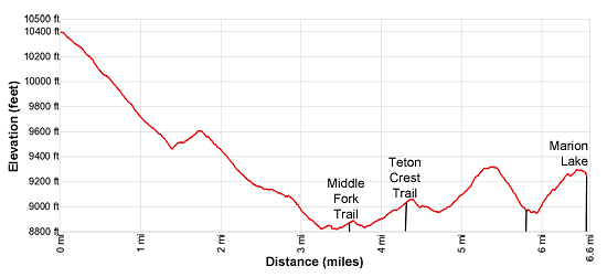
- Elevation: 10,400-ft. - 9,239-ft.
- Elevation Gain: -1,161-ft.
- Difficulty: strenuous
- Trail Highlights: See Trail Intro
- Basecamp(s): Grand Teton NP / Jackson Hole
- Region: The Tetons
Ride the Jackson Hole Aerial Trail to the start of this long, strenuous hike journeying into the Tetons backcountry. The path follows a scenic section of the Teton Crest trail to pretty Marion Lake, nestled in bench beneath the divide.
Tram to Marion Lake
Ride the Jackson Hole Aerial Tram (fee), located in Teton Village, to the start of this hike at the summit of Rendezous Mountain (10,455-ft.). (See driving directions below for more information.) The 12.0 minute ride soars 4,139-ft. vertical feet to a panoramic overlook with views of the Tetons, the Jackson Hole Valley and the surrounding mountain ranges.
From the overlook the summits of Grand Teton, Middle Teton, South Teton and Mount Wister are visible above Mount Hunt (10,783-ft.) along with unnamed summits towering above the north side of Granite Canyon. Fossil Mountain and Mount Bannon rise above the ridge above Death Canyon Shelf to the northwest. Jackson Hole, Jackson Lake and the Gros Ventre Mountains dominate the views to the east/northeast. Rendezvous Peak (10,927-ft.) towers above the valley floor to the south.
From the tram station follow the ski area service road descending on moderate grades. Reach a junction at 0.4 miles where the service roads turns left. We continue straight ahead down a broad track. At 0.7 miles a sign points right to a trail heading toward Marion Lake and Granite Canyon. This is the Rendezvous Mountain trail.
Turn right on the Rendezvous Mountain trail which descends switchbacks on moderately-steep grades through scattered trees to a granite-rimmed bowl at 1.4 miles, losing a little over 1,000-ft. from the top of the tram. Along the way pass a sign marking the boundary of Grand Teton National Park. Keep in mind you need to climb back up this hill on the return journey.
From the bottom of the bowl nice views extend north to Mount Hunt and the other summit rising above Granite Canyon. The path now climbs the ridge along the west side of the bowl, gaining a little over 200-ft in 0.3 miles.
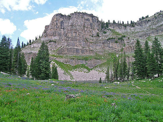
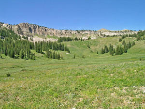
The trail now descends southwest on moderate grades through trees and intermittent meadows with nice views of the surrounding peaks. At 2.9 miles the trail curves to the northwest and the trees give way to pretty meadows with scattered trees. In season wildflowers adorn the meadows. Ahead views open to Housetop Mountain (10,537-ft.) and unnamed summits along the Continental Divide.
Reach the low point of the trail and a creek crossing at 3.2 miles. The path now ascends on moderately-easy grades to the junction with the Middle Fork trail, branching left at 3.6 miles. The Rendezvous Trail turns right and drops down to Granite Canyon. We bear left on the Middle Fork trail toward the Teton Crest and Marion Lake.
After a brief descent the trail climb through lovely meadows scattered with small copses of trees to a junction with the Teton Crest trail at 4.3 miles. The trail to the left leads to Moose Creek Divide. We turn right toward Marion Lake.
Our trail now descends to cross Middle Fork Creek at 4.6 miles and then climbs moderate to moderately-steep grades to a saddle on the ridge separating the Middle Fork and North Fork of Granite Canyon. Along the way enjoy nice views of the ridge rimming the head of the Middle Fork. I have seen moose grazing in the lush meadows along the valley floor.
As you crest the saddle views open north to Fossil Mountain and unnamed summit towering above Marion Lake (unseen). Housetop Mountain rises above the divide to the northwest.
From the saddle the path drops on moderately-steep to steep grades to the floor of the North Fork in a half mile, reaching the junction with the Granite Canyon trail at 5.8 miles. Continue straight ahead on the Teton Crest trail, which crosses a nascent creek and the climbs moderately-steep to steep grades up the north side of the valley. As you climb enjoy fine views down Granite Canyon. Rendezvous Mountain dominates the views to the southeast.
At 6.25 miles the trail tops the pretty bench cradling Marion Lake. A short climbs over a low hill leads to the southeastern shore of Marion Lake (9,239-ft.) at 6.5 miles. A granite cliff towers above the west side of the lake. The bench is clad in beautiful meadows, filled with wildflowers in late July, and clusters of trees. The small backcountry campsite is situated to the east of the lake.
Elevation Profile
Driving Directions
From Jackson, WY: From the main square at North Cache and Broadway, head west on West Broadway (US-191 S / US-26 W) for 1.4 miles and turn right on turn right on WY-22 W. (There is a large Albertson’s Supermarket on the southwest corner of the intersection.) Follow WY-22 W for 4 miles and turn right (north) on the road signed for Teton Village (WY 390 N / Moose-Wilson Road).
Travel 6.3 miles and turn left on the Teton Village Road. In 0.3 miles the road forks, bear right staying on the Teton Village Road. Take the next left and park in the large parking lot. The Gondola Station for the Jackson Hole Aerial Tram is located northwest of the parking area. See the Jackson Hole Aerial Tram site for the latest information on schedules and prices.
Trail Resources
Trail Intro / Trail Photo Gallery / Trail Map
Basecamp(s) Information:
Grand Teton NP / Jackson Hole
Region Information:
The Tetons
Other Hiking Regions in:
Wyoming