Details: Surprise and Amphitheater Lakes 
Distance: 9.8 - 10.5 miles (round trip)
Grand Teton National Park, near Grand Teton NP in The Tetons
Hike Facts
- Distance: 9.8 - 10.5 miles (round trip)
- Elevation: 6,720-ft. - 9,870-ft.
- Elevation Gain: 3,150-ft. - 3,150-ft.
- Difficulty: moderate-strenuous
- Trail Highlights: See Trail Intro
- Basecamp(s): Grand Teton NP / Jackson Hole
- Region: The Tetons
A scenic hike to two lovely lakes tucked in a rugged cirque beneath Disappointment Peak. Views from the lakes extend to high summits of the Teton Range; Middle Teton, Grand Teton, Mount Owen and Teewinot Mountain.
Trailhead to Amphitheater Lake
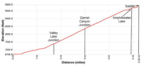
The trail to Amphitheater Lake leaves from the west end of the Lupine Meadows Trailhead (see driving directions below). Follow the trail as it heads south through trees on easy grades, crossing a bridge over a stream in Glacier Gulch at 0.6 miles. Beyond the crossing the grade steepens as the path travels through forest and brushy meadows on moderate grades. Openings offer brief glimpses of Teewinot Mountain (12,235-ft.) and Grand Teton (13,770-ft.)
After a mile the trail curves to the west. Soon good views briefly open to Teewinot Mountain and the Grand Teton towering overhead. The path now climbs a low ridge separating Glacier Gulch, to the north, from Burned Wagon Gulch, to the south. As you ascend views open to Nez Perce (11,901-ft.) rising above the south side of Garnet Canyon. Teewinot is seen through the trees to the northwest.
At 1.7 miles pass the junction with the Valley Trail, branching left and dropping down to Bradley and Taggart Lakes. Past the junction the trail climbs moderately-steep switchback up the broad ridge between Glacier Gulch and Garnet Canyon. The brushy meadows amid scattered trees offer good views of Jackson Hole to the south. Soon views open to Bradley and Taggart Lakes, nestled in forested glacial bowls to the south.
The stiff climb up the well-constructed trail offers little cover, making for a hot climb during the summer. Get an early start to ascend the switchbacks during the cool of the morning.
At 3.0 miles pass the junction with the Garnet Canyon trail branching left. The trees thicken, restricting views, as we continue climbing switchbacks up the broad ridge. At 3.9 miles, at the north end of a switchback, Jenny and Jackson Lakes are seen through the trees. A short distance beyond this point the trail starts ascending a series of short switchbacks.
The grade abates as the switchbacks end at 4.6 miles. The trail now ascends west on moderate grades through emerald green meadows set amid fir trees. Grand Teton towers above Disappointment Peak (11,618-ft.) to the west. Pyramid-shaped Mount Owen (12,928-ft.) rises to the north of the Grand. Nez Perce dominates the views to the southwest.
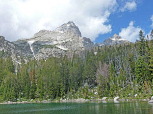
Reach the short spur trail to Surprise Lake (9,540-ft.) at 4.7 miles. The nicest views of pretty little Surprise Lake are along the eastern shore where Disappointment Peak, Grand Teton and Mount Owen fill the skyline to the west.
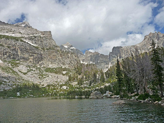
The trail now travels through trees above the north shore of Surprise Lake, passing a few campsites along the way. At 4.9 miles arrive at beautiful Amphitheater Lake (9,698-ft.). The aptly named lake lies nestled in a granite amphitheater beneath Disappointment Peak. Stunning views extend west to Middle Teton, Disappointment Peak, Grand Teton, Mt. Owen and Teewinot Mountain.
The lake is typically the end point for many hikers. I highly recommend following the trail along lake’s north shore that climbs to a saddle on the ridge rimming the north side of the cirque at 5.25 miles. The path climbs 175-ft. through stunted Whitebark pines and fir trees with fine views of the summits Middle Teton and Grand Teton rising beyond Disappointment Peak. As you crest the saddle views open to Glacier Basin where Mount Owen, East Prong and Teewinot Mountain towering above massive mounds of glacier debris deposited by the receding Teton Glacier. The glacier lies unseen beyond a protruding ridge. The rugged crags of Disappointment Peak loom overhead.
Further travel beyond the ridge should be left to well-equipped parties, skilled at crossing steep snowfields and route finding along rugged moraines. My advice is to enjoy the views from the saddle and then retrace your steps to the trailhead for a memorable 10.5 miles round-trip hike.
Note: The Amphitheater Lake trail is very busy with day hikers visiting the lakes and climbers seeking to summit the high peaks. I strongly advise getting an early start to get a parking spot in the very busy and crowded Lupine Meadows trailhead.
It is not unusual to see bears grazing amid the high brushy meadows along the trail. Plan accordingly – make noise and travel in a group.
Elevation Profile
Driving Directions
From Jackson, WY: From the main square at North Cache and Broadway, head north on North Cache Street (US-191 N / US-26 E) for 12.4 miles to Moose Junction and turn left on Teton Park Road. Follow Teton Park Road for 1.0 mile, past the main visitor center, to the entrance/fee station. Continue beyond the entry station for 6.2 miles and turn left on the road signed for Lupine Meadows. Follow the road for 1.2 miles to the large parking area at the end of the road. This is a very popular area and the parking lot fills early. Additional parking is available 0.4 miles back down the road.
From Teton Village, WY: Head out of the village and turn left on the Moose-Wilson Road. Follow the road for 1.1 miles to the park entrance/fee station. Beyond the fee station drive 6.9 miles on the narrow, winding road and turn left on Teton Park Road. Follow Teton Park Road for 0.4 miles to the park entrance/fee station. Continue beyond the entry station for 6.2 miles and turn left on the road signed for Lupine Meadows. Follow the road for 1.2 miles to the large parking area at the end of the road. This is a very popular area and the parking lot fills early. Additional parking is available 0.4 miles back down the road.
Trail Resources
Trail Intro / Trail Photo Gallery / Trail Map
Basecamp(s) Information:
Grand Teton NP / Jackson Hole
Region Information:
The Tetons
Other Hiking Regions in:
Wyoming