Details: Teton Crest 
Distance: 35.6 miles (one way)
Grand Teton National Park, near Grand Teton NP in The Tetons
Hike Facts
- Distance: 35.6 miles (one way)
- Elevation: 6,800-ft. - 10,800-ft.
- Elevation Gain: 3,600-ft. - 4,000-ft.
- Difficulty: moderate-strenuous
- Trail Highlights: See Trail Intro
- Basecamp(s): Grand Teton NP / Jackson Hole
- Region: The Tetons
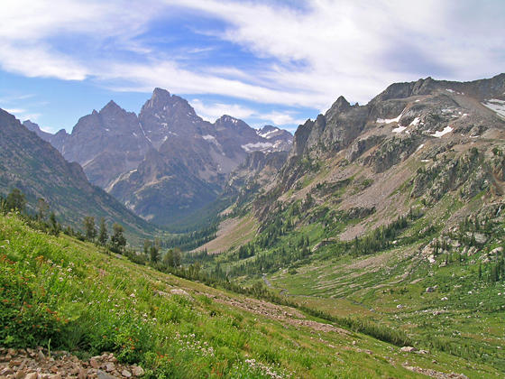
Breathtaking views of towering granite peaks, gorgeous glacier-carved valleys, lovely lakes and meadows awash in wildflowers greet hikers on this popular backpack through the heart of the Teton Range.
Tram to Marion Lake
Distance from Trailhead: 6.5 miles (one way)
Ending/Highest Elevation: 10,400-ft.
Elevation Gain: 1,400-ft.
Note: There is a lot of up and down on this segment. The elevation gain is 1,400-ft and the loss is 2,532-ft. over 6.5 miles.
Ride the Jackson Hole Aerial Tram (fee), located in Teton Village, to the start of this hike at the summit of Rendezous Mountain (10,455-ft.). The 12.0 minute ride soars 4,139-ft. vertical feet to a panoramic overlook with views of the Tetons, the Jackson Hole Valley and the surrounding mountain ranges.
From the overlook the summits of Grand Teton, Middle Teton, South Teton and Mount Wister are visible above Mount Hunt (10,783-ft.) along with the unnamed summits towering above the north side of Granite Canyon. Fossil Mountain and Mount Bannon rise above the ridge above Death Canyon Shelf to the northwest. Jackson Hole, Jackson Lake and the Gros Ventre Mountains dominate the views to the east/northeast. Rendezvous Peak (10,927-ft.) towers above the valley floor to the south.
From the tram station follow the ski area service road descending on moderate grades. Reach a junction at 0.4 miles where the service roads turns left. We continue straight ahead down a broad track. At 0.7 miles a sign points right to a trail heading toward Marion Lake and Granite Canyon. This is the Rendezvous Mountain trail.
Turn right on the Rendezvous Mountain trail which descends switchbacks on moderately-steep grades through scattered trees to a granite-rimmed bowl at 1.4 miles, losing a little over 1,000-ft. from the top of the tram. Along the way pass a sign marking the boundary of Grand Teton National Park.
From the bottom of the bowl nice views extend north to Mount Hunt and the other summit rising above Granite Canyon. The path now climbs the ridge along the west side of the bowl, gaining a little over 200-ft in 0.3 miles.
The trail now descends southwest on moderate grades through trees and intermittent meadows with nice views of the surrounding peaks. At 2.9 miles the trail curves to the northwest and the trees give way to pretty meadows with scattered trees. In season wildflowers adorn the meadows. Ahead views open to Housetop Mountain (10537-ft.) and unnamed summits along the Continental Divide.
The trail crosses a creek at 3.2 miles and then ascends on moderately-easy grades to the junction with the Middle Fork trail, branching left at 3.6 miles. The Rendezvous Trail turns right and drops down to Granite Canyon. We bear left on the Middle Fork trail toward the Teton Crest and Marion Lake.
After a brief descent the trail climb through lovely meadows scattered with small copses of trees to a junction with the Teton Crest trail at 4.3 miles. The Teton Crest trail to the left leads to Moose Creek Divide. We turn right toward Marion Lake.
The Teton Crest trail descends to cross Middle Fork Creek at 4.6 miles and then climbs moderate to moderately-steep grades to a saddle on the ridge separating the Middle Fork and North Fork of Granite Canyon. Along the way enjoy nice views of the ridge rimming the head of the Middle Fork. I have seen moose grazing in the lush meadows along the valley floor.
As you crest the saddle views open north to Fossil Mountain and unnamed summit towering above Marion Lake (unseen). Housetop Mountain rises above the divide to the northwest.
From the saddle the path drops on moderately-steep to steep grades to the floor of the North Fork in a half mile, reaching the junction with the Granite Canyon trail at 5.8 miles. Continue straight ahead on the Teton Crest trail, which crosses a nascent creek and the climbs moderately-steep to steep grades up the north side of the valley. As you climb enjoy fine views down Granite Canyon. Rendezvous Mountain dominates the views to the southeast.
At 6.25 miles the trail tops the pretty bench cradling Marion Lake. A short climbs over a low hill leads to the southeastern shore of Marion Lake (9,239-ft.) at 6.5 miles. A granite cliff towers above the west side of the lake. The bench is clad in beautiful meadows, filled with wildflowers in late July, and clusters of trees. The small backcountry campsite is situated to the east of the lake.
Marion Lake to Alaska Basin
Distance from Trailhead: 7.6 miles (one way)
Ending/Highest Elevation: 9,726-ft.
Elevation Gain: 1,455-ft.
Note: There is a lot of up and down on this segment. The elevation gain is 1,455-ft and the loss is 1,227-ft. over 7.6 miles.
The Teton Crest trail travels along the eastern shore of Marion Lake and then curves to the north, traveling through pretty meadows as it ascends to a saddle atop the Continental Divide at 7.0 miles. You are now out of the park and walking in the Jedediah Smith Wilderness in Targhee National Forest.
The trail descends across a broad bench, wandering through lovely meadows on easy grades. South Teton, Middle Teton and Grand Teton dominate the view to the northeast. Spearhead Peak rises above the plateau to the east. Fossil Mountain towers above the head of the Fox Creek Valley.
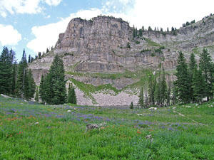
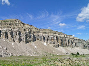
The trail soon crosses Fox Creek Pass (9,600-ft.) and then ascends to a junction with the Death Canyon Trail, branching right, at 8.5 miles. You have now crossed back into the park. Continue straight ahead on the Teton Crest Trail. Ahead are amazing views of the rugged cliffs towering above Death Canyon Shelf, a bench clad in beautiful meadows. Peaks rising along the ridge from south to north are Fossil Mountain, Mount Bannon, Mount Jedediah Smith and Mount Meeks.
After a brief ascent the trail traverses the shelf on an undulating trail, passing several nice campsites. Views stretch northeast to the high peaks of the Teton Range. To the east Prospector Mountain, Peak 10,988 and Peak 10,905 tower above Death Canyon.
At the northeast end of the shelf the trail climbs on moderately-easy grades to Meeks Pass (9,726-ft.) at 11.9 miles. Mount Meeks (10,681-ft.) rises above the pass to the west. A sign at the pass marks the boundary for Grand Teton National Park. You are now back in the Jedediah Smith Wilderness in Targhee National Forest.
Beyond the pass the path wanders across a high bench, passing the junction with the Teton Shelf Trail at 12.0 miles. Here views extend northwest to the cliffs along the Teton Shelf and the Wedge, the distinctive formation along the ridge.
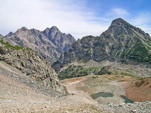
At the end of the bench the trail steeply descends the Sheep Steps to the head of Teton Canyon at 13.0 miles. In the canyon the trail ascends on easy grades, crossing the South Fork of Teton Creek before arriving at the Basin Lakes (aka Alaska Basin) and the junction with the South Fork of Teton Canyon trail at 14.1 miles. Eight scenic lakes lie nestled amid granite knolls, meadows and scattered trees in the gorgeous basin. The easiest access to the basin is via the South Fork trail. Use trails along the South Fork lead to various camping area. Please remember to choose an established site and camp at least 200-ft. away from water sources.
Alaska Basin is a great place to camp, although it can get quite crowded. Bears frequent the basin, so make sure you food is secured on a bear canister, which you must carry anyway if you are camping along the Teton Crest trail in the park. My advice is to arrive in Alaska Basin early in the afternoon to secure a good site. This will leave you time to hike the scenic South Teton trail ascending to Static Divide Pass (10,790-ft.), a saddle on the ridge to the south of Buck Mountain (11,938-ft.).
Alaska Basin to Lake Solitude
Distance from Trailhead: 11.0 miles (one way)
Ending/Highest Elevation: 10,400-ft.
Elevation Gain: 2,563-ft.
Note: There is a lot of up and down on this segment. The elevation gain is 2,563-ft and the loss is 2,994-ft. over 11.0 miles.
From the junction the Teton Crest and South Teton trails in Alaska Basin, ascends north on the Teton Crest trail, reaching the junction with the Alaska Basin Shelf trail at 14.9 miles. A short, moderately-steep descend leads to Sunset Lake at 15.3 miles. Beyond the lake the trail climbs steep to moderately-steep grades up the north side of Teton Canyon. Turn around for fine views of rugged ridge and the Wedge rising above the Teton Shelf. Mount Meeks towers above Meeks Pass. In the distance are the summits rising above Death Canyon and beyond.
Reach Hurricane Pass (10,400-ft.) at 16.8 miles. South, Middle and Grand Tetons dominate the views to the east. To the northeast are the peaks rising along Cascade Canyon. Mount Moran (12,605-ft.) in the distance.
From the pass the trail turns northeast, descending on moderately-steep switchbacks to a bench scattered with small tarns. The Schoolroom Glacier clings to the slopes to the south. Moraines dam the meltwater pond at the foot of the glacier. To the east are stunning views of Grand, Middle and South Tetons.
The steep descent soon resumes as the trail drops down a series of benches. At 18.8 miles the trail curves to the left (north) and continues down the canyon. Ahead are fine views of the peaks rimming the west side of South Fork Canyon. Near the foot of the canyon views open to a pretty waterfall tumbling down the steep slopes below Grand Teton.
Reach the Forks of Cascade Canyon at 22.4 miles. Here the South and North Fork of Cascade Canyon meet. The trail to the east heads down the main fork of Cascade Canyon to the boat dock at the foot of the Canyon. (This is a good escape route if severe weather is threatening or your party has run into difficulties.)
At the Forks of Cascade Canyon we turn left (northwest) up the North Fork of Cascade Canyon toward Lake Solitude and Paintbrush Divide. The path now climbs through trees on moderate grades, crossing a wood bridge to the east side of the canyon. As you climb the trees give way to pretty meadows with ever improving views of the glacial valley, rimmed by rugged granite peaks. Turn around to the south for breathtaking views of the Cathedral Group; Teewinot Mountain, Mount Owen and Grand Teton, towering above the foot of the valley.
At 23.3 miles the trail crosses a small wood bridge back to the west side of the North Fork of Cascade Canyon. Beyond the bridge the trail angles away from the creek, ascending on moderate to moderately-steep grades along the west side of the valley. At 23.4 miles pass a sign marking the start of the North Fork of the Cascade camping zone. Wooden stakes mark the various campsites.
As you climb the trail passes through small copses of trees, traverses rock falls and boulder fields and climbs up rock outcroppings. Above the trail to the west interesting rock formations grace the ridges extending from the Wigwam Peaks. To the south the Cathedral Group creates a stunning backdrop for the scenic valley.
Near the head of the valley views open to a pretty waterfall spilling down the rugged slopes above the trail. The falls is fed by Mica Lake, nestled in a hanging valley along the western wall. Ahead are views of the ridge and peaks rimming the head of the valley.
Soon the trail crosses the steam below the falls. The well-watered area around the steam supports a profusion of wildflowers. A short distance beyond a small sign marks the end of the camping zone (24.6 miles).
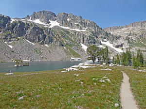
At 24.8 miles the path crosses a wood bridge over Lake Solitude’s outlet stream gushing down a steep, rocky stream bed. A short distance beyond the grade abates as the trail crests the scenic bench, ringed by a cirque of granite peaks, cradling Lake Solitude (9,035-ft.).
At 25.1 miles reach a junction with the trail to Paintbrush Divide branching right. A spur trail, to the left, leads to Lake Solitude’s eastern shore. The stunning lake is surrounded on three side by rocky meadows sprinkled with wildflowers. Peak 10,686 towers above the lake to the west while sheer cliffs rim the valley wall to the northwest. Teewinot, Owen and the Grand Teton dominate the view to the south.
Lake Solitude to the String Lake Parking Area
Distance from Trailhead: 10.5 miles (one way)
Ending/Highest Elevation: 10,715-ft.
Elevation Gain: 1,935-ft.
Note: There is a lot of up and down on this segment. The elevation gain is 1,935-ft and the loss is 4,107-ft. over 10.5 miles.
From the junction with Lake Solitude the trail curves to the right (northeast/east) as it diagonals up meadows and talus slopes toward Paintbrush Divide. The ascent enjoys terrific views of Lake Solitude, Mount Owen, Grand Teton, Middle Teton and South Teton. With binoculars or a zoom lens you should be able to see across Hurricane Pass to the high peaks towering above the Teton Shelf.
Reach wind swept Paintbrush Divide (10,715-ft.) at 27.3 miles. Woodring Mountain rises to the east. Mount Saint John and Rockchuck Mountain tower above Paintbrush Canyon to the southeast. Below the pass a small tarn lies cradled in a rocky bowl.
Descend steep switchbacks down the east side of the pass. Views soon open to Mount Moran and Thor Peak towering above Leigh Canyon to the northeast. Beyond the switchbacks the moderately-steep descent continues down the rugged canyon. Soon views open to a small pond nestled in the talus slopes below the canyon’s south ridge.
After a mile the trail splits. Bear left to reach Holly Lake and some nice campsites at 29.1 mile. The pretty lake lies beneath rugged cliffs along the south facing slopes of Mount Woodring.
Beyond Holly Lake the descent down Paintbrush Canyon continues on moderately-steep grades, traveling through trees and talus slopes. As you descend views open to Jackson Lake to the east. At 31.9 miles the grades eases. In another miles the trail curves to the right (south) and reaches the junction with the String Lake Loop trail at 34.0 miles.
Which way you go on the loop depends where you are parked. Turn left if you are parked at the end of the String Lake Road. After crossing the bridge over the Leigh Lake outlet stream turn right and travel along String Lake’s eastern shore to the first parking area (the Leigh Lake Trailhead).
Continue straight ahead on the loop if you are parked in the first parking area along the String Lake Road. This section of the loop travels through avalanches slopes beneath the east facing slopes of Woodchuck Mountain. Here views open east to the Gros Ventre Mountains and String Lake. Pass through a copse of trees and then more meadows to the foot of String Lake where the trail turns left (east). Pass a junction with the Jenny Lake Trail, to the right. Beyond the Jenny Lake Trail junction walk for 0.3 miles back to the first parking area at the foot of Jenny Lake at 35.6 miles.
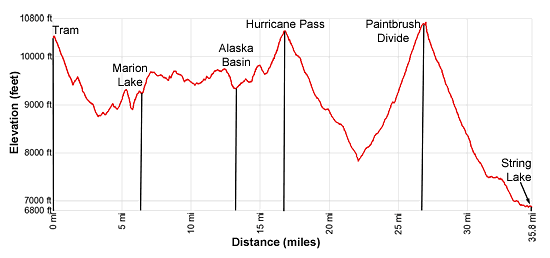
Elevation Profile
Driving Directions
To start the Backpack:
From Jackson, WY: From the main square at North Cache and Broadway, head west on West Broadway (US-191 S / US-26 W) for 1.4 miles and turn right on turn right on WY-22 W. (There is a large Albertson’s Supermarket on the southwest corner of the intersection.) Follow WY-22 W for 4 miles and turn right (north) on the road signed for Teton Village (WY 390 N / Moose-Wilson Road).
Travel 6.3 miles and turn left on the Teton Village Road. In 0.3 miles the road forks, bear right staying on the Teton Village Road. Take the next left and park in the large parking lot. The Gondola Station for the Jackson Hole Aerial Tram is located northwest of the parking area. See the Teton Village Tram site (http://www.jacksonhole.com/summer-ride-the-tram.html) for the latest information on schedules and prices.
End Point for the Backpack
From Jackson, WY: From the main square at North Cache and Broadway in Jackson Hole, WY, head north on North Cache Street (US-191 N / US-26 E) for 12.4 miles to Moose Junction and turn left on Teton Park Road. Follow Teton Park Road for 1.0 mile, past the main visitor center, to the entrance/fee station. Continue beyond the entry station for 9.8 miles to the North Jenny Lake Junction and turn left on the Jenny Lake Road.
Drive 1.5 miles on the Jenny Lake Road and then turn right onto String Lake Road. Turn right in 230-ft into the first parking lot near the foot of String Lake and park. The start of the String Lake trail is located at the south end of the parking area. This is a very small lot.
If the lot is full, continue on the String Lake Road for 0.3 miles to the parking lot at the end of the road. The Leigh Lake trailhead starts at the north end of the parking area to the left of the bathrooms. Get an early start. This is a popular area with limited parking.
From Teton Village, WY: Head out of the village and turn left on the Moose-Wilson Road. Follow the road for 1.1 miles to the park entrance/fee station. Beyond the fee station drive 6.9 miles on the narrow, winding road and turn left on Teton Park Road. Follow Teton Park Road for 0.4 miles to the park entrance/fee station. Continue beyond the entry station for 9.8 miles to the North Jenny Lake Junction and turn left on the Jenny Lake Road.
Drive 1.5 miles on the Jenny Lake Road and then turn right onto String Lake Road. Turn right in 230-ft into the first parking lot and park. The start of the String Lake trail is located at the south end of the parking area. This is a very small lot. If full, continue on the String Lake for 0.3 miles to the parking lot at the end of the road. The Leigh Lake trailhead starts at the north end of the parking area to the left of the bathrooms. This is a popular area with limited parking.
Trail Resources
Trail Intro / Trail Photo Gallery / Trail Map
Basecamp(s) Information:
Grand Teton NP / Jackson Hole
Region Information:
The Tetons
Other Hiking Regions in:
Wyoming