Backpack: Big Sandy to Skull Lake Basecamp 
Distance: 19.8 - 20.4 miles (round trip)
Bridger Wilderness, Bridger-Teton National Forest, near Big Sandy in Wyoming's Wind River Range
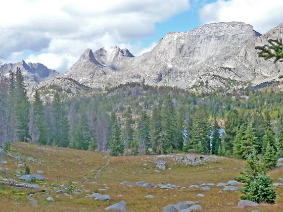
Mt Hooker, Tower Peak, Glissade Peak and Mt Bonneville on the descent to Skull Lake
Families and parties looking for an easy backpack into a basecamp with great day hiking and fishing opportunities will love the trip to the Washakie Creek and East Fork Valleys featuring splendid scenery with plenty of high peaks and lovely lakes.
- Distance: 19.8 - 20.4 miles
- Elevation: 9,085-ft. at Trailhead
9,741-ft at Dad’s Lake
9.878-ft. at Marms Lake
10,160-ft. at Shadow Lake Trail Junction
10,090-ft at Washakie Creek
10,282-ft. at Skull Lake - Difficulty: moderate
- More Hikes in:
Big Sandy / Wyoming's Wind River Range
Introduction
From the Big Sandy trailhead follow the Fremont Trail as it heads north on easy to moderate grades, paralleling the west side of the Continental Divide. Along the way the trail passes Meeks, Mirror, Dads and Marms Lakes and offers fine views of the massive cirque at the head of the East Fork Valley. Beyond Marms Lake follow the Pyramid Lake trail to a crossing of Washakie Creek. On the north side of the creek the trail climbs to Skull Lake at 10.2 miles, nestled at the foot of the East Fork Valley.
Setup a basecamp either along Washakie Creek or above the south or west shores of Skull Lake. From either location it is easy to reach Maes and Pyramid Lakes, hike to Hailey and/or Washakie Passes, travel to Shadow, Billys, Barren and Texas Lakes set amid a backdrop of the high peaks on west side of the Cirque of the Towers or wander further afield on an off-trail route that explores the beautiful and unspoiled Desolation Valley in the upper East Fork basin.
The basecamp destinations can be reachable in a long day. Alternatively, break up the trip to the basecamp with an overnight stop at Dad’s Lake. You might also want to move your basecamp part way through the trip to beautiful Shadow Lake. Keep in mind that Shadow Lake is a very popular spot that gets quite crowded during the height of the summer.
Although you can get a taste of the area on a long weekend I recommend allocating 5 to 7 days to relax, explore and fish.
Trail Detail
See the Big Sandy Trailhead to Marms Lake description for information on the first segment of this backpack.
See the Marms Lake to Skull Lake description for information on the final leg of the backpack. This description also including information on day hiking to Maes and Pyramid Lakes along with the route to Desolation valley in the upper East Fork basin.
Day Hikes:
- Washakie Pass – 8.2 miles (round-trip) from the foot of Skull Lake - The climb to Washakie Pass (11,611-ft.) features breathtaking views of the South Fork cirque. Atop the pass, views open east to sheer cliffs and high peaks towering above Macon and Washakie Lakes, nestled in the alpine basin below the pass.
- Hailey Pass -- 6.2 miles (round trip) from the foot of Skull Lake – This trail travels beneath Pyramid Peak and past the pretty Twin Lakes to Hailey Pass (11,160-ft.) where views open east to the Musembeah massif (12,593-ft.) along with Redwall Peak, Buttress Mountain and Grave Peak (12,255-ft.) rising above emerald green meadows of the Baptiste and Grave Creek Valleys. Mt Hooker’s distinctive profile towers above the pass to the northwest.
-Shadow Lake Trail -- 7.2 – 11.0 miles (round trip) from the foot of Skull Lake – This scenic hike heads east up the Washakie Creek valley on easy grades to Shadow Lake, nestled in a forested bowl beneath the west side (backside) of the Cirque of the Towers. From Shadow Lake a scenic use trail climbs to Billys, Barren and Texas Lakes set amid alpine meadows and surrounded by high peaks.
Elevation Profile
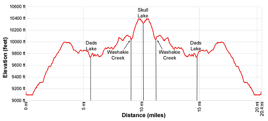
Mileage and Elevation Detail
| Miles | Elevation | Destination | |
|---|---|---|---|
| 0.0 | 9,085-ft. | Big Sandy Trailhead) | |
| 0.6 | 9,120- ft. | Junction Sedgewick Meadow / Big Sandy (bear left) ) | |
| 1.3 | 9,320-ft. | Junction Diamond Lake (bear left) ) | |
| 1.5 | 9,355-ft. | Junction Fremont Trail (bear right) ) | |
| 5.5 | 9,741-ft. | Dad’s Lake) | |
| 6.8 | 9,878-ft. | Marms Lake) | |
| 7.4 | 9,925-ft. | Junction with Pyramid Lake Trail (bear right) ) | |
| 9.0 | 10,160-ft. | Pass the Shadow Lake trail) | |
| 9.1 | 10,090-ft. | Washakie Creek Crossing) | |
| 9.9 | 10,410-ft. | Junction with Washakie Pass) | |
| 10.2 | 10,282-ft. | Skull Lake) | |
| -- Side Trip: +4.4 (RT) to Maes (10,343-ft.) and Pyramid Lakes (10,570-ft.) | |||
| -- Side Trip: +8.2 (RT) to Washakie Pass (11,611-ft.) | |||
| -- Side Trip: +6.2 (RT) to Hailey Pass (11,160-ft.) | |||
| -- Side Trip: +7.2 - 11.0 (RT) to Shadow Lake (10,287-ft.) and Texas Lakev(10,770-ft.) | |||
Trailhead Driving Directions
The Big Sandy Trailhead is located in the southern Wind River Range next to the Big Sandy River.
Directions from Pinedale: From the intersection of Pine Street (US 191) and North Tyler Ave (the Pinedale Tourism office is located on the northeast corner) in Pinedale, WY, drive south on Highway 191 for 11.7 miles and then turn left (east) on WY-353. After 15.5 miles you will notice signs referring to the road as the Big Sandy-Elkhorn Road and after 18 miles the paved road will change to a good packed dirt/gravel surface.
Shortly after the pavement ends go straight through a junction, and drive south crossing the Big Sandy River (Buckskin Crossing). Follow the road for a total of 27.3 miles. Shortly after crossing the Big Sandy River you will reach a junction with the Lander Cutoff Road (the next junction). Turn left on the Lander Cutoff Road. There is a wood sign at the intersection pointing toward the Big Sandy trailhead.
Drive 7.0 miles on the Lander Cutoff Road and then turn left on the Big Sandy Opening Road. Here you will see a sign for the Big Sandy Campground and trailhead. The road now deteriorates and narrows. Blind corners and lush foliage along the road make it hard to see ahead. Drive carefully, following the rocky, rutted road for 9.8 miles to a "Y" intersection. Bear right at the intersection to continue along the Big Sandy Opening Road (Forest Service Road 850). (The road branching to the left leads to the Big Sandy Lodge and Mud Lake.) Follow the road for 0.8 miles to the trailhead parking area, equipped with an outhouse.
Allow an hour and a half to reach the trailhead from Pinedale. The parking area is too small for the number of backpackers visiting the area during the height of the summer. If the parking area is full, find a safe place to park off the access road.
I recommend a high clearance vehicle to reach the trailhead. Passenger cars can make it OK if driven carefully. Check at the Pinedale ranger station before starting your trip to learn about current road and trail conditions. The Ranger Station is located to the east of the Ridleys Grocery Store on US 191 (Pine Street in Pinedale). The entrance to the ranger station is on the Fremont Lake Road. (You can also reach the parking area for the ranger station by driving east through the Ridley’s parking lot.)
This trailhead is remote, so be sure to have a full tank of gas. The dirt road become slippery when wet. The campground at the parking area is tiny, with only 4 sites. I would not plan on camping at the trailhead before starting your backpack.
Trail Resources
Trail Photo Gallery / Trail Map
Basecamp(s) Information:
Big Sandy
Region Information:
Wyoming's Wind River Range
Other Hiking Regions in:
Wyoming