Backpack: Texas Pass - Cirque of the Towers - Jackass Pass Loop
Segment 2: Marms Lake to Shadow Lake Trail Junction
Distance: 1.6 - 5.0 miles (one way)
Bridger Wilderness, Bridger-Teton National Forest, near Big Sandy in Wyoming's Wind River Range
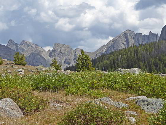
Backside of the Cirque from Washakie Creek
- Distance: 1.6 - 5.0 miles
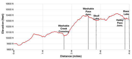
- Elevation: 0.0 miles to Junction with Pyramid Lake Trail (9,925-ft.)
1.6 miles to Junction Shadow Lake Trail (10,160-ft)
1.7 miles to Washakie Creek Crossing (10,090-ft.)
2.5 miles to Junction Washakie Pass Trail (10,410-ft.)
2.8 miles to Skull Lake (10,282-ft.)
3.8 miles to Junction Hailey Pass Trail (10,360-ft.)
4.0 miles to Mae’s Lake (10,343-ft.)
5.0 miles to Pyramid Lake (10,570-ft.) - Difficulty: moderate
- Basecamp: Big Sandy
- Region: Wyoming's Wind River Range
Marms Lake to Shadow Lake Trail Junction Description
The Pyramid Lake trail, starting just north of Marms Lake, leads to the junction of the Washakie Pass trail, Skull Lake, Mae’s Lake and Pyramid Lake near the head of the scenic East Fork Valley. Skull Lake, just 0.4 miles from the Washakie Pass junction, offers nice campsites and is a popular overnight stop for backpacking bound for Washakie Pass. Mae’s Lake, 0.2 miles beyond the Hailey Pass junction, features scenic campsites and is a good place to spend the night before heading over Hailey Pass.
Beyond Mae’s the trail climbs to beautiful Pyramid Lake, set in a bowl beneath Mount Hooker and Pyramid Peak. From Pyramid Lake a route crossing a saddle to the north of Midsummer Dome leads to the head of the main East Fork River.
A half day or more spent fishing and exploring the area is well worth the time.
Marms Lake Junction to Washakie Pass Junction
The junction of the Pyramid Lake trail with the Fremont trail is located a short distance to the north of Marms Lake. Here the Pyramid Lake Trail, signed for Shadow Lake, heads northeast. The path skirts the north side of a low knoll, crosses a small stream and then ascends on easy grades along the south side of a rocky hillside, avoiding the marshy meadows at the head of Marms Lake.
Soon the trail turns left (north) and climbs a narrow draw on moderate to moderately-steep grades, staying to the left (west) of the inlet stream for Marms Lake. At 0.7 miles the trail reaches the top of the draw and then descends on easy grades, crossing two minor streams.
Past the streams the path ascends to a bench where small ponds lie nestled amid meadows, scattered trees and rock outcroppings. Great views extend north to the cirque at the head of the East Fork Valley formed by Mount Geikie (12,378-ft.), Mount Bonneville (12,585-ft.), Tower Peak (12,330-ft.), Mount Hooker (12,504-ft.) and Pyramid Peak (12,030-ft.). Mount Washakie and Big Chief Mountain tower above the north side of the Washakie Valley.
At 1.6 miles pass the Shadow Lake trail branching right (east). Backpacks hiking the Texas Pass-Cirque of the Towers Loop should turn right here. Otherwise, continue straight ahead on the Pyramid Lake Trail, which now descend to south shore of Washakie Creek at 1.7 miles. Just before the creek pass a second trail heading right (east) toward Shadow Lake. To the east are fine views of the backside of the Cirque of the Towers including Wolf Head Peak (12,163-ft.), Overhanging Tower (12,164-ft.) and Sharks Nose (12,229-ft.).
The trail now crosses the wide creek. You will probably need to remove your boots and wade the creek. Late in the season and during periods of low water you may be able to rock-hop across and keep your feet dry. Nice campsites are located along the south side of the creek to the west of the crossing, and along the north side of the creek to the east of the crossing.
Beyond the creek the path ascends the north side of the valley on moderate grades, traveling through meadows and then a forest of spruce, fir and pine trees. As you climb openings in the trees provide ever-improving views of the backside of the Cirque of the Towers.
The trail tops out at 2.4 miles. Here views open to Washakie Pass, the saddle on the ridge between Mount Washakie (12,524-ft.) and Bernard Peak (12,193-ft.).
The path now descends to Skull Lake on moderate grades. A short distance past the high point, reach the junction with the trail to Washakie Pass at 2.5 miles. Backpackers wishing to camp at Skull Lake or Maes’s Lake should continue down the trail. Otherwise parties wishing to cross Washakie Pass should turn right (east) on the Washakie Pass Trail.
Washakie Pass Junction to Skull and Maes Lakes
The short descent to Skull Lake enjoys great views of the cirque at the head of the East Fork Valley. Reach the foot of Skull Lake (10,282-ft.) at 2.8 miles. From the lakeshore views extend to Bernard Peak and Dike Mountain (12,458-ft.) rising to the east/northeast. Mount Geikie, Ambush Peak and Raid Peak tower above the basin to the northwest. Good campsites are located above the south and west sides of the lake.
To continue to Mae’s Lake, rock-hop across Skull Lake’s outlet stream and then follow the Pyramid Lake Trail as it travels along the left (west) side of the lake on an undulating path that climbs over low knolls and dodges rock outcroppings.
Reach the head of the lake at 3.2 mile. Here the trail ascends a draw, climbing on moderate grades along the left (west) side of the inlet stream. The path tops out at 3.6 miles and then descends to Mae’s Lake. As you approach the lake reach the junction with the trail to Hailey Pass, branching right (northeast), at 3.8 miles. Backpackers planning on camping at Mae’s Lake should continue down the trail. Otherwise parties wishing to cross Hailey Pass should turn right (northeast) on the Hailey Pass trail. (LINK)
Beyond the junction the Pyramid Lake Trail descends to the foot of Mae’s Lake (10,343-ft.) at 4.0 miles. Pyramid Peak and Mt. Hooker dominate the view to the north. Hailey Pass, the notch of the ridge to the south of Pyramid Peak, is now in view. Nice campsites are found to the south of the lake.
Side Trip to Pyramid Lake
I highly recommend a side trip to Pyramid Lake, located a mile north of Mae’s Lake. To reach the lake, follow the Pyramid Lake Trail as it skirts the west side of Mae’s Lake. At the head of the lake climb the draw to the Pyramid Lake basin. Mt Hooker and Pyramid Peak form the backdrop for lovely Pyramid Lake (10,570-ft.). Glissade and Tower Peaks rise to the north.
From Pyramid Lake a route crossing a saddle to the north of Midsummer Dome leads to the head of the beautiful and unspoiled Desolation Valley in the upper East Fork basin. The route to the upper basin skirts the left (west) side of Pyramid Lake. At the inlet stream at the head of the lake turn left (west) and climb the drainage to the saddle on the ridge, passing a few ponds along the way. Here stunning views open to the upper basin. Descend from the saddle and then traverse the right (east) side of Lake 10566. From the foot of Pyramid Lake to the head of Lake 10566 is about 2.5 miles. Note: Routes are only recommended for experienced parties. Always carry a map and be sure to turn around as you hike to identify landmarks to help you find the route back to your campsite.
Return to Segment 1: Big Sandy Trailhead to Marms Lake
Go To Segment 3: Shadow Lake over Texas Pass to Cirque of the Towers
Elevation Profile
Backpack Segments
- Introduction: Texas Pass - Cirque of the Towers - Jackass Pass Loop
- Segment 1: Big Sandy Trailhead to Marms Lake
- Segment 2: Marms Lake to Shadow Lake Trail Junction
- Segment 3: Shadow Lake over Texas Pass to Cirque of the Towers
- Segment 4: Cirque of the Towers to Big Sandy Trailhead
Driving Directions to Big Sandy Trailhead
The Big Sandy Trailhead is located in the southern Wind River Range next to the Big Sandy River.
Directions from Pinedale: From the intersection of Pine Street (US 191) and North Tyler Ave (the Pinedale Tourism office is located on the northeast corner) in Pinedale, WY, drive south on Highway 191 for 11.7 miles and then turn left (east) on WY-353. After 15.5 miles you will notice signs referring to the road as the Big Sandy-Elkhorn Road and after 18 miles the paved road will change to a good packed dirt/gravel surface.
Shortly after the pavement ends go straight through a junction, and drive south crossing the Big Sandy River (Buckskin Crossing). Follow the road for a total of 27.3 miles. Shortly after crossing the Big Sandy River you will reach a junction with the Lander Cutoff Road (the next junction). Turn left on the Lander Cutoff Road. There is a wood sign at the intersection pointing toward the Big Sandy trailhead.
Drive 7.0 miles on the Lander Cutoff Road and then turn left on the Big Sandy Opening Road. Here you will see a sign for the Big Sandy Campground and trailhead. The road now deteriorates and narrows. Blind corners and lush foliage along the road make it hard to see ahead. Drive carefully, following the rocky, rutted road for 9.8 miles to a "Y" intersection. Bear right at the intersection to continue along the Big Sandy Opening Road (Forest Service Road 850). (The road branching to the left leads to the Big Sandy Lodge and Mud Lake.) Follow the road for 0.8 miles to the trailhead parking area, equipped with an outhouse.
Allow an hour and a half to reach the trailhead from Pinedale. The parking area is too small for the number of backpackers visiting the area during the height of the summer. If the parking area is full, find a safe place to park off the access road.
I recommend a high clearance vehicle to reach the trailhead. Passenger cars can make it OK if driven carefully. Check at the Pinedale ranger station before starting your trip to learn about current road and trail conditions. The Ranger Station is located to the east of the Ridleys Grocery Store on US 191 (Pine Street in Pinedale). The entrance to the ranger station is on the Fremont Lake Road. (You can also reach the parking area for the ranger station by driving east through the Ridley’s parking lot.)
This trailhead is remote, so be sure to have a full tank of gas. The dirt road become slippery when wet. The campground at the parking area is tiny, with only 4 sites. I would not plan on camping at the trailhead before starting your backpack.
Trail Resources
- Backpack Intro
- Segment Photo Gallery
- Segment Map
- Trailhead(s) Information: Big Sandy
- Region Information: Wyoming's Wind River Range
- Other Hiking Regions in: Wyoming