Details: Whiskey Mountain 
Distance: 6.8 - 9.2 miles (round trip)
Fitzpatrick Wilderness, Shoshone National Forest, near Dubois in Wyoming's Wind River Range
Hike Facts
- Distance: 6.8 - 9.2 miles (round trip)
- Elevation: 7,595-ft. - 10,960-ft.
- Elevation Gain: 10,960-ft.
- Difficulty: moderate-strenuous
- Trail Highlights: See Trail Intro
- Basecamp(s): Dubois
- Region: Wyoming's Wind River Range
Far reaching views, extending to the Tetons, the peaks gracing the southern end of the Absaroka Range and the summits of the northern Wind River Range, are the rewards of the hike to the saddle between Whiskey Mountain’s twin summits.
Whiskey Mountain
The trailhead for Whiskey Mountain, shared by the Lake Louise and Glacier trails, starts at the southwest end of the Trail Lake parking area. (See trailhead directions below.) The path heads west across dry sage-covered flats and then starts climbing moderate to moderately-steep switchbacks up the south facing slopes of Whisky Mountain. There is little to no shade along the open slopes scattered with sage and junipers, making this segment of the walk very hot during the height of the summer. An early start is strongly advised.
After a half mile pass a signed junction where the Glacier Trail branches left (south). (This is also the trail to Lake Louise.) At 0.6 miles a sign marks the boundary of the Fitzpatrick Wilderness. Views now extend south/southwest up the East Torrey Creek Valley to Torrey Peak. Soon pyramid-shaped Peak 11,695 and Arrow Mountain join the scene. Above you are the rugged cliffs and outcroppings along the southern slopes of Whiskey Mountain.
As the trail gains elevation pine trees appear along the slopes. Unfortunately the pine bark beetle infestation is killing some of the older trees.
As you climb great views open to high meadows along the west facing slopes of Arrow Mountain. Look carefully and you will see the Old Glacier Trail, still used by outfitters, crossing the meadows. The saddle, to the left of peak 11,695, is the high point (10,895-ft.) on the first segment of the Glacier Trail.
At 2.0 miles the path crosses and old rock slide and then enters a forest. On a hot day the shade is a welcome relief. The grade abates a bit as the trail travels through conifers and intermittent meadows. Wildflowers grow amid the meadows.
The ascent soon steepens as the trail crests a minor ridge at 2.75 miles. Atop the broad ridge the path travels through tree-fringed meadows on easy grades. The respite is brief. At 2.9 miles the ascent resumes on moderate to moderately-steep grades through meadows and clusters of trees. A few small springs support a profusion of wildflowers during the height of the summer. Open areas offer great views of meadow clad slopes of Arrow Mountain and Peak 11,695.
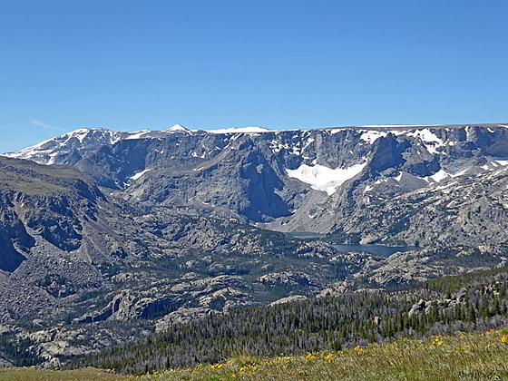
At 3.2 miles the path crosses a few seasonal streams that support a variety of wildflowers. A short distance beyond the path travels along the south edge of a bench with terrific views of Arrow Mountain and peaks rising above the East Torrey Creek valley to the south. Soon views open southwest to Hidden Lake nestled beneath Middle Mountain and the stunning, glacier-clad cliffs beneath the Shale Mountain and Ram Flat Plateaus.
At 3.4 miles reach a junction. Here the trail to Ross Lake branches left (southwest) and descends through meadows toward the lake. We bear right (northwest) on a narrow trail ascending on moderately-steep grades through vast alpine meadows, sprinkled with tiny wildflowers, along Whiskey Mountain’s southern slopes. The trail soon fades and then disappears. To stay on track, look for wood posts and rock cairns marking the route. The route keeps to the left side of the meadows near the edge of the ridge.
As the route gains elevation grand views slowly unfold and evolve to the southwest. Downs Mountain and Peak 13,202 tower above Ram Flat and the Shale Mountain plateaus. Soon Ross Lake is seen cradled in a rocky bowl beneath the cliffs. The large expanse of snow to the north of Down Mountain is the Continental Glacier. To the south are more fine views of Arrow Mountain and Peak 11,695. Nearer-at-hand, tiny flowers and colorful lichens adorn the meadows.
At 4.0 miles the grade moderates as the trail curves to the right. Soon views open straight ahead to a rounded, rocky mound. This is the lower (11,098-ft.) of Whiskey Mountain’s two summits. Our goal, the saddle between the two summits, is to the right of the mound.
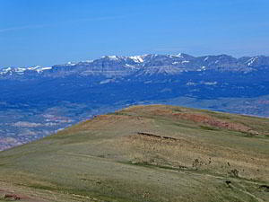
Reach the saddle (10,960-ft.) between Whiskey Summit 11,098-ft. (left) and 11,157-ft. (right) at 4.6 miles. Here panoramic views stretch in all directions. To the northwest the Teton’s jagged summits punctuate the horizon along with Breccia Peak, Pinnacle Buttes and the high volcanic cliffs of the Brooks Lake area. The Absaroka Range fills the skyline to the north. The northern peaks of the Wind River Range dominate the view to the south.
To summit Whiskey Mountain, ascend east from the saddle. Soon you may intercept a trail climbing on easy to moderate grades toward the summit. It soon fades. The way is obvious. Reach the summit after hiking an addition 0.6 miles and gaining 197-ft. (Total distance to the summit is 10.4 miles round-trip.) Views here extend to the colorful badlands to the east of Dubois and the same views seen from the saddle. Unless tagging the summit is important, I would recommend enjoying the views at the saddle and then retracing your steps to the trailhead for a scenic 9.2 mile (round trip) hike.
Elevation Profile

Driving Directions
From Dubois: From the corner of N 1st Street and US 26 in Dubois, drive 3.7 miles east on US 26 / US 287 and then turn right onto Whiskey Basin/Trail Lake Road. The turn is a short distance beyond the bridge crossing Jakeys Fork. Almost immediately turn left to stay on Trail Lake Road (aka Forest Service #411). (The turn to the right leads to the Fish Hatchery.) Follow the road for 9.1 miles to its end at the Trail Lake parking area. Here you will find the Glacier, Whisky Mountain, Lake Louise and Bomber Basin trailhead.
Note: Before reaching the end of the road there are left turns leading to a parking area for horse trailers and an overflow parking area.
Trail Resources
Trail Intro / Trail Photo Gallery / Trail Map
Basecamp(s) Information:
Dubois
Region Information:
Wyoming's Wind River Range
Other Hiking Regions in:
Wyoming