Details: West Maroon Pass 
Distance: 3.4 - 13.0 miles (round trip)
Maroon Bells-Snowmass Wilderness, White River National Forest, near Aspen in Central Colorado
By: Diane Greer
Hike Facts
- Distance: 3.4 - 13.0 miles (round trip)
- Elevation: 9,580-ft. - 12,500-ft.
- Elevation Gain: 496-ft. - 2,920-ft.
- Difficulty: strenuous
- Trail Highlights: See Trail Intro
- Basecamp(s): Aspen
- Region: Central Colorado
Imposing peaks, pretty waterfalls, stunning lakes, a huge alpine basin and panoramic views of the Maroon Bells, Pyramid Peak and Treasure Mountain from a 12,500-ft. pass are the scenic rewards on this 13-mile (RT) hike to West Maroon Pass.
Trailhead to Crater Lake
Distance from Trailhead: 3.4 miles (round trip)
Ending/Highest Elevation: 10,076-ft.
Elevation Gain: 496-ft.
Few trails can surpass the stunning views from the start of the West Maroon Pass hike at the foot of Maroon Lake. Mirrored in the lake’s waters are the iconic Maroon Bells (14,156-ft. and 14,014-ft.), towering above the head of the valley. Pyramid Peak’s (14,018-ft.) jagged crags rise to the south while the crimson spires of the Sievers Mountains form the backdrop for beautiful aspen groves to the north.
Follow the Maroon-Snowmass trail along Maroon Lake’s north (right) shore to a junction at the "Deadly Bell's Kiosk" near the head of the lake. Progress will be slow along this section of the trail as the gorgeous scenery invites frequent stops.
At the junction the Scenic Loop Trail branches left. We turn right to stay on the Maroon-Snowmass trail, which ascends a wide rocky path through Aspen and spruce trees along the northwest side of the valley. Openings in the trees offer views of rugged Pyramid Peak rising to the south.
About a mile from the start the moderately steep trail climbs an ancient rock slide forming a natural dam that created Crater Lake. As you reach the top of the slide enjoy wonderful views of the Maroon Bells and the Sleeping Sexton, located on the ridge extending north from North Maroon Peak.
From the top of the slide the trail descends gently toward Crater Lake. Slightly before reaching Crater Lake arrive at a junction at 1.7 miles. Continue straight ahead (south) on the West Maroon trail toward Crater Lake and West Maroon Pass. The Maroon-Snowmass trail to the right (west) leads to Buckskin Pass.
Crater Lake to West Maroon Pass
Distance from Trailhead: 13.0 miles (round trip)
Ending/Highest Elevation: 12,500-ft.
Elevation Gain: 2,920-ft.
After descending to the foot of Crater Lake the trail traverses the lake’s right (west) shore. Along the way enjoy wonderful views of the Maroon Bells. (Backpackers will find designated campsites among the trees on the west side of the lake.)
At the head of the lake vistas open up the valley. Watch for waterfalls cascading down the valley's west wall along this section of the trail.
The trail now follows a gentle grade through meadows, willow thickets and trees and then climbs steeply over a rockslide spilling from the eastern flanks of Maroon Peak. Be sure to turn around at the top of the slide and enjoy great views down the valley.
Beyond the slide the trail negotiates a narrow corridor between the creek and talus fields, passing through willows tickets and conifer stands. As the corridor constricts, the trail crosses a few talus fields before being forced to cross to the east side of the creek at 3.6 miles. Early in the season you will need to wade the creek. As the snow runoff subsides you should be able to rock hop across the braided channel without getting your feet wet.
On the east side of the creek the ascent steepens as the path bashes its way through a large thicket of willows and then continues climbing through a landscape of scrub growth interspersed with conifer stands, some of which harbor nice campsites. Depending on the time of year you might see waterfalls spilling down the valley's east wall along this segment of the trail.
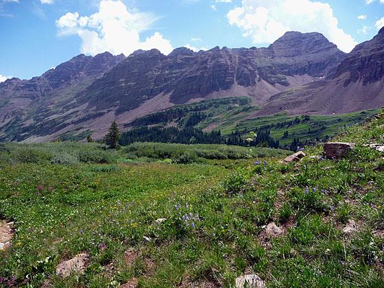
At 4.5-miles the trail crosses back to the west side of the creek and continues its ascent. Soon the last of the trees give way to meadows interspersed with thickets of scrub willows. The grade now steepens as you approach the head of the valley, a large basin rimmed with maroon cliffs and clad in emerald green meadows sprinkled with wildflowers. Be sure to turn around as you climb and take in the wonderful views of the Pyramid massif towering above the eastern side of the valley.
The trail through the basin’s meadows veers right (west) as it negotiates the rolling landscape. Near the head of the basin the path crests a rise and heads southwest toward a low point on the ridge. As you near the ridge the way to the pass becomes apparent. The final slog through meadows on the stiff ascent to the pass gains 800-ft. in 0.7 miles.
From the top of the pass views extend west to Treasure Mountain. Below are the vast meadows of Purity Basin. To the northeast the Maroon Bells and Pyramid massifs fill the skyline. Belleview Mountain rises along the rugged ridge extending northwest from the pass.
The pass is the turnaround point for most day hikers. Backpackers use the trail as either the first or last leg of the popular 26.6-mile Four Pass Loop, a 3-5 day backpacking trip climbing four passes over 12,000-ft. in the Maroon-Snowmass Wilderness.
Note to Backpackers: Beyond the designated camping sites a Crater Lake camping came be found in the conifer stands along the east and west side of the West Maroon Valley. If you are doing the Four Pass Loop it is best to camp before West Maroon Pass or after Frigid Air Pass. Camping is very difficult in the Purity Basin between the two passes.
With proper planning it is possible to cross West Maroon Pass on a day hike and end up at the East Fork trailhead in Schofield Park, 14 miles from Crested Butte. (For more information see the West Maroon Pass from Crested Butte trail description.) You need to spot a car at the Schofield Park trailhead, arrange a ride (Dolly's Mountain Shutte: (970) 349-2620) or try to hitch your way back to Crested Butte (not recommended on the infrequently traveled road).
Some folks make this into a two day trip by staying in Crested Butte overnight and then arranging transportation to the East Maroon trailhead for a 16-mile one-way hike back to the East Maroon Trailhead. You then need to catch the shuttle bus back to Aspen Highlands.
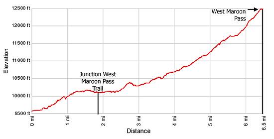
Elevation Profile
Buy the BookThis opinionated guide includes all the hikes in the Aspen, Buena Vista, Crested Butte, Marble and Leadville sections of the website plus info on local services and nearby attractions. | |
Driving Directions
Driving Directions from Aspen:
From Aspen: The Maroon Bells has limited accessibility by car. From June 9th through October 8th the Maroon Creek Road is restricted to vehicles from 8:00 a.m. to 5:00 p.m. beyond the T-Lazy 7 Ranch, unless you have campground reservations or you are overnight backpacking.
A shuttle bus, which leaves every 20 minutes, departs from the Aspen Highlands ski area. There is paid parking at Aspen Highlands or you can take the free Castle Maroon Bus from the Rubey Park Transit Center in downtown Aspen to Aspen Highlands. Dogs are allowed on the bus. Bus tickets that cover the bus and admission to the Maroon Bells Scenic area are sold at Four-Mountain Sports in Aspen Highlands. Check the White River National Forest website for the latest information before setting out on your trip.
Please note the Maroon Bells Scenic Area is a recreation fee area. The Interagency, Senior & Golden Access Passes are honored. Fees apply at all times. Self-pay stations are available during off hours.
If you are driving to the Maroon Bells Scenic Area or Aspen Highlands for the shuttle bus from downtown Aspen, follow Hwy 82 heading west to the roundabout just outside of town. Exit the roundabout at the Maroon Creek Road. In approximately one mile reach Aspen Highlands, turn left here for the shuttle.
If arriving during non-bus hours or heading to the backpacker's overnight parking area, continue another 4 miles to the Maroon Bells Scenic Area Welcome Station. The use fee will be collected here, or in the fee tube immediately behind the station if unmanned. Continue another 5 miles to the parking lot at Maroon Lake. Parking is VERY limited in both the day use and overnight lots.
Trail Resources
Trail Intro / Trail Photo Gallery / Trail Map
Basecamp(s) Information:
Aspen
Region Information:
Central Colorado
Other Hiking Regions in:
Colorado