Best Hikes in Grand Staircase-Escalante National Monument, Utah
Location: South Central Utah
On Utah Scenic Byway 12, 269 miles southwest of Grand Junction, CO, 300 miles northeast of Las Vegas, NV and 312 miles south of Salt Lake City, UT.
By: Diane Greer
Escalante Hiking Trails
Distance: 5.3 - 7.2 miles (Round Trip)
Difficulty: easy-moderate
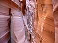
Beautiful Zebra Canyon, a narrow, convoluted slot streaked with pink and white stripes, will delight hikers of all ages. Combine the hike with nearby Tunnel Slot, a long narrow slot, for a great day hike down the Hole in the Rock Road.
Distance: 5.0 - 14.0 miles (Round Trip)
Difficulty: moderate
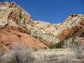
This beautiful hike, one of my favorites in the Escalante area, travels through a gorgeous canyon beneath towering white Navajo and red Wingate sandstone walls.
Distance: 8.8 - 10.4 miles (Round Trip)
Difficulty: moderate-strenuous
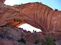
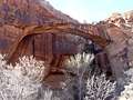
This scenic hike visits an interesting arch set high atop the north wall of Phipps Wash. An optional extension travels to Maverick Bridge.
Distance: 5.8 miles (Round Trip)
Difficulty: easy
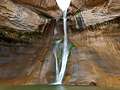
This good introductory hike to the Escalante National Monument travels up a scenic canyon and leads to the base of lower Calf Creek Falls, a beautiful 126-ft. tall cascade.
Distance: 4.0 - 14.0 miles (Round Trip)
Difficulty: moderate
A scenic canyon with an interesting natural bridge, an arch, rock art and a small ruin make for a nice day hike in the Grand Staircase-Escalante National Monument.
View Hikes by Area:
South Central UtahEscalanteBryceCapitol Reef