Best Hikes in Driggs, ID
Location: Wyoming's Teton Range
Driggs Hiking Trails
Distance: 13.0 miles (Round Trip)
Difficulty: strenuous
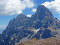
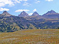
My favorite trail on the west side of the Tetons features jaw-dropping views of Grand, Middle and South Tetons towering above Cascade Canyon. The long, strenuous trail ascends Table Mountain where views extend from Mount Moran in the north to Mount Bannon in the south.
Distance: 7.2 - 15.6 miles (Round Trip)
Difficulty: moderate-strenuous
Lovely forests and meadows filled with wildflowers along with views of peaks rimming South Leigh Canyon, Fred’s Mountain and the summit of the Grand Teton, are the rewards of this hike up a pretty canyon. Parties looking for an easier hike can turn around at the meadows, located at 3.6 miles.
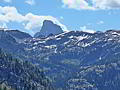
South Teton Trail to Mirror Lake in Alaska Basin ![]()
Distance: 5.4 - 15.8 miles (Round Trip)
Difficulty: moderate-strenuous
Wildflowers and great views of the peaks and cliffs rimming the South Fork Teton Canyon are the highlights of this long hike, best done as a backpack, climbing to beautiful Alaska Basin. Day hikers will find a scenic turn around point in the meadows below the basin.
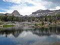
Green Lakes and Granite Basin Lakes Loop ![]()
Distance: 10.2 - 14.2 miles (Loop)
Difficulty: strenuous
Ascend through forest and meadows to the Green Lakes Basin at the head of North Leigh Canyon, tucked between Green Mountain and the Continental Divide. Extend the hike by crossing the divide to Granite Basin Lakes, nestled at the head of South Leigh Canyon.
Distance: 8.0 - 14.0 miles (Round Trip)
Difficulty: moderate-strenuous
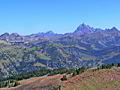
This trail on the west (back) side of the Teton Range climbs steeply to the scenic Teton Shelf with fine views of the granite cliffs towering above the shelf, the peaks rising above Alaska Basin and the summits of Grand, Middle and South Tetons.
Distance: 5.6 miles (Round Trip)
Difficulty: moderate
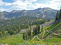
This popular, family friendly hike ascends lovely meadows filled with beautiful wildflowers in the pretty Coal Creek Valley. The path leads to Mesquite Divide, a saddle with views of Grand Teton, Rendezvous Peak and the high ridge to the south of Moose Lakes.
Distance: 7.2 - 8.8 miles (Round Trip)
Difficulty: strenuous
Wildflowers and far reaching views of the high peaks in the Tetons, Gros Ventre, Snake River and Big Hole Ranges are the highlights of this scenic trail ascending the beautiful meadows of the Coal Creek Valley before climbing to the summit of Taylor Mountain.
Distance: 6.8 - 8.2 miles (Round Trip)
Difficulty: strenuous
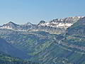
Great views of the Tetons and the peaks rimming the North and South Fork of Teton Canyon are the highlights of this off-the-beaten path trail climbing steeply up the north slopes of the North Fork to the ridge crest. Extend the hike by following a use trail along the panoramic ridge.
View Hikes by Area:
Wyoming's Teton RangeGrand Teton NPJacksonDriggsTogwotee Pass