Best Hikes in Lake City, Colorado
Location: Southwest Colorado
On CO-149, 55 miles southwest of Gunnison and 119 miles northwest of Alamosa.
By: Diane Greer
Lake City is a great basecamp to enjoy the excellent hiking trails in nearby Uncompahgre and Gunnison National Forests and the Gunnison BLM district. View Lake City Info
Introduction
Lake City (8,663-ft.) is a remote little Victorian town situated at the confluence of the Lake Fork of the Gunnison River and Henson Creek and surrounded by the Uncompahgre and Gunnison National Forests and the Gunnison BLM district. The town is located along CO-149, 55 miles south of Gunnison and 74 miles north of South Fork.
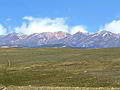
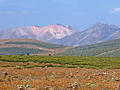
With close to one thousand square miles of public land nearby there is no shortage of excellent hiking opportunities. Trails climb the area’s five 14,000-ft. peaks, wander through wildflower-filled meadows and traverse vast expanses of alpine tundra. Since this remote corner of the state is still relatively unknown hikers can enjoy a degree of solitude not possible in other areas of the state.
Lake City Hiking Trails
Distance: 2.3 - 5.4 miles (Round Trip)
Difficulty: strenuous
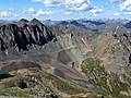
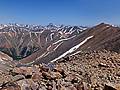
This terrific hike wanders through beautiful American Basin, visits scenic Sloan Lake and then ascends to the summit of Handies Peak (14,048-ft.) with spectacular panoramic views of the San Juan Mountains.
Distance: 7.8 miles (Round Trip)
Difficulty: strenuous-difficult
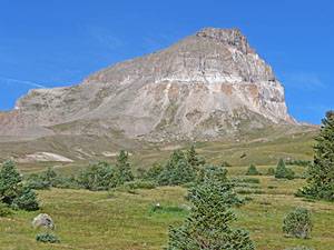
Stunning panoramic views are the rewards for hiking to the top Uncompahgre Peak (14,309-ft.), the sixth highest fourteener in Colorado and the highest point in the San Juan Mountains.
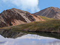
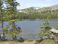
Cataract Lake (aka Cataract Gulch) ![]()
Distance: 4.2 - 10.0 miles (Round Trip)
Difficulty: moderate-strenuous
Beginning in dense woods the trail passes cascades and waterfalls along Cataract Creek, travels through beautiful alpine meadows and visits a scenic alpine lake on its way to the Continental Divide.
Spring Creek Pass East to Snow Mesa ![]()
Distance: 6.4 - 10.0 miles (Round Trip)
Difficulty: moderate-strenuous
Hikers ascending from Spring Creek Pass to the beautiful, tundra-clad plateau of Snow Mesa are rewarded with glorious views of the San Juan Mountains to the west/southwest of the Lake City area. Extend the hike by climbing Baldy Cinco or walking to the ponds at the east end of the mesa.
Distance: 9.0 - 11.8 miles (Round Trip)
Difficulty: strenuous-difficult
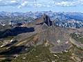
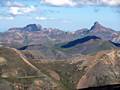
A great hike leads to the top of two of the easiest fourteeners to climb in Colorado, Redcloud (14,034 ft.) and Sunshine (14,001 ft.) peaks. From the summits a sea of peaks and ridges extend in all directions, encompassing large swaths of the San Juan Mountains.
Distance: 8.2 miles (Round Trip)
Difficulty: moderate-strenuous
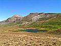
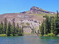
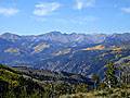
A stiff ascent through aspen groves, forest and meadows leads to pretty Crystal Lake set against the eastern slopes of Crystal Peak. Fine views encompass the vast tundra-clad plateaus to the east and the high peaks towering above Henson Creek to the south.
Distance: 5.0 miles (Round Trip)
Difficulty: moderate-strenuous
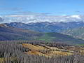
This great half day hike ascending Mesa Seco features splendid views of the San Juan Range rising to the west of the Lake City area along with the Slumgullion Earthflow, a huge, slow-moving landside that broke off the west side of mesa.
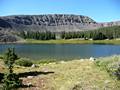
Spring Creek Pass West to Jarosa Mesa ![]()
Distance: 8.8 miles (Round Trip)
Difficulty: moderate
Hike a section of the Continental Divide/Colorado Trail from Spring Creek Pass to Jarosa Mesa for great views of the San Juan Range, including Uncompahgre Peak, Matterhorn Peak, Red Mountain, Redcloud Peak and Sunshine Peak.
Distance: 7.6 miles (Round Trip)
Difficulty: moderate-strenuous
This gorgeous hike travels up a seldom visited valley to a scenic lake tucked in a high basin. Here you will experience a level of solitude not found on hikes to the nearby 14ers. Extend the hike by climbing to a saddle overlooking Lee Smelter Gulch to the north.
Distance: 8.0 miles (Round Trip)
Difficulty: strenuous-difficult
The top of Handies Peak offers breathtaking views of the San Juan Mountains. This alternative route to the summit is longer and more strenuous but less traveled than the more popular trail to Handies Peak via American Basin.
Distance: 14.0 miles (Round Trip)
Difficulty: strenuous
Picturesque groves of mature aspen and beautiful views of the Lake Fork Valley and Uncompahgre Peak are a few of the visual delights on this scenic trail following the Devil's Creek drainage to Devil's Lake, lying beneath the western flanks of the Calf Creek Plateau.
Distance: 7.8 miles (Round Trip)
Difficulty: strenuous
A stiff climb leads to a scenic bench and a pretty lake high above the east side of the Lake City.
Distance: 7.8 - 9.6 miles (Round Trip)
Difficulty: moderate
An interesting hike through forest and meadows to a scenic lake basin nestled beneath the eastern escarpment of the Calf Creek Plateau (12,644-ft.) in the Powderhorn Wilderness.
View Hikes by Area:
Southwest ColoradoOurayTellurideSilvertonLake City
| Support our Site |
Around Town
In the late 1800’s Lake City served as a supply hub and smelting center for miners in the nearby San Juan Mountains. In its heyday the town saw the construction of more than 500 structures. Mining activity and the population of the town and Hinsdale County peaked around 1900. Over the next century mining activity waned and the town went through a period of decline.
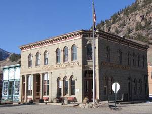
Today the charming Victorian town, a designated national historic district, is a hub for outdoor enthusiasts exploring the area’s stunning mountain terrain. Over 200 of Lake City’s original Victorian structures, including commercial buildings, churches, homes, cabins and public buildings, still stand, many restored to their former glory.
Highly recommended is an evening stroll along the town’s wooden sidewalks and backstreets to see the restored structures from the 1870’s and 1880’s. Also of interested are the nicely preserved circa 1930-1950 motor court cabins. A pamphlet with a map of the self-guided tour of the historic district is available at the Lake City Visitor Center and the Hinsdale County Museum, at the corner of Second and Silver Street. The museum, run by the Hinsdale County Historic Society and chronicling the area’s history, is also worth a visit.
Other short walks around Lake City include the Henson Creek trail and the River Access trail system. A pamphlet and map describing the walking trails is available at the Visitor Center.
For a glimpse of mining life take a tour of the Hard Tack Mine. The underground mine tour describes the tools and techniques used by hard rock miners and includes exhibits explaining local mining history and equipment along with a rock gallery showcasing the mine’s huge collection of rocks and minerals. The Hard Tack is located on County Road 20 (the Henson Creek Road) toward Engineer’s Pass, just 2.5 miles outside of town.
The Ute-Ulay Mine/Henson Ghost Town, located 3.5 miles out County Road 20, features a shelf-guided walking tour of the 12-acre property. The walk takes visitors by mining structures, a boarding house and an interesting dam. Signs along the way describe the history of the area.
If your dogs are tired from hiking take a drive along the Silver Thread Scenic Byway. The route heads south from Lake City on CO-149 to Windy Point, located just before Slumgullion Pass. From this vantage point panoramic views encompass four 14,000-ft. peaks, Redcloud Peak (14,034 ft.), Sunshine Peak (14,001 ft.), Uncompahgre Peak (14,309-ft.), and Wetterhorn Peak (14,015-ft.), towering above the town to the northwest. Below is Lake San Cristobal and to the north the Slumgullion Earthflow, comprised of two major earthflows. The first flow occurred about 700 years ago when a huge mass of volcanic rock slumped down the valley, damming the Lake Fork of the Gunnison River and creating Lake San Cristobal. The second slide, visible from Windy Point, started 300 years ago and is still moving down the hillside. The bizarre angle of the trees growing along the hillside illustrates the continued movement of the slide.
The byway continues over Slumgullion Pass heading south to Creede, along the way passing through incredibly beautiful landscape. A few miles north of Creede is the turnoff to the Rio Grande Reservoir. The reservoir is stocked with fish and open to boats.
Creede, located near the headwaters of the Rio Grande, is a nicely preserved rustic mining town. The historic structures along the town’s main drag, Historic Street, are now home to a few restaurants and shops. Beyond Creede the road parallels the Rio Grande beneath towering cliffs, ending in South Fork.
The byway also heads north from Lake City, again following CO-149 to Blue Mesa Lake and the Curecanti National Recreation Area, located on Highway 50 to the west of Gunnison. There are a number of short hikes in Curecanti, including the Dillon Pinnacles, Pine Creek and Never Sink, that are good rainy day destinations. Stop at the Elk Creek Visitor Center along Highway 50 for more information.
Just two miles south of town on US-149 is the turnoff for County Road 30 (CR 30) leading to Lake San Cristobal. This beautiful lake is a great place for fishing, boating, kayaking and canoeing. The Red Gulch Day Use area at the south end of the lake includes picnic facilities. The county-owned Wupperman Campground is located on the east side of the lake.
Four wheel drive enthusiasts will want to check out the Alpine Loop National Backcountry Byway. The byway is composed of several jeep roads that link Lake City with Ouray and Silverton to the west. The byway’s network of roads traverse stunning scenery, visit ghost towns and cross passes up to 12,880-ft. Check with the Lake City Visitor Center at 800 Gunnison Avenue for information on road conditions and technical skills required to navigate the route and the areas other 4WD roads.
Food, Lodging and Services
For a small town Lake City has a nice selection of accommodations, restaurants and retail shops. Accommodations include B&B’s, small motels, lodges and cabins in town and at Lake San Cristobal. There are also a variety of homes and apartments available as vacation rentals.
People who prefer camping will find five campgrounds in the Uncompahgre and Gunnison National Forests near Lake City. There is also the county-owned Wupperman Campground at Lake San Cristobal, located on the east side of the lake. For a list of other public camping facilities got to the Lake City website. There are also a number of private campgrounds and RV parks in the area.
Your first stop in town should be the Visitor Center on 800 Gunnison Avenue, where you can pick up a map, learn about current conditions and get advice on recreation activities and nearby attractions. For groceries the only game in town is the Country Store Grocery at 916 N State Highway 149, which carries the basics needed to assemble a meal.
A wonderful selection of baked goods and fresh bread is available at the Lake City Bakery, at 922 N Highway 149. The Chillin Internet Coffee Shop and Cafe is the best place in town for a caffeine injection. For a complete list of local retail shops and services visit the Lake City Chamber of Commerce.