Best Hikes in Eastern Switzerland
Featured Hikes
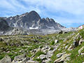
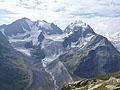
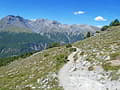
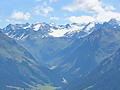
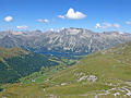
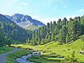
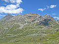
Fluela – Schwarzhorn - Durrboden ![]()
Distance: 6.4 - 8.1 miles (One Way)
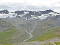
This epic hike summits the Schwarzhorn, crosses two panoramic passes and visits four scenic valleys in route to Durrboden. Highlights include the high peaks towering above the Lower Engadine, the cirque at the head of the Grialetsch Valley and the summits rimming the Dischma, Funtauna and Tschuvel Valleys.
Distance: 11.0 miles (One Way)
This terrific hike crosses two panoramic passes, Sertig Pass and Scaletta Pass, and travels through five scenic valleys. Along the way hikers enjoy splendid views of Piz Kesch, Piz Vadret, the Ducan Ridge, the Schwarzhorn and the Chuealphorn, to name a few.
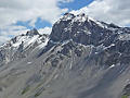
Distance: 5.0 miles (Round Trip)
Breathtaking views of the summits towering above the Upper Engadine and Bernina Valleys reward hikers completing the very steep climb to the summit of Piz Languard. This summit is one of the easier 3,000-meter peaks to scale, with a good, albeit rugged, trail going to the top.
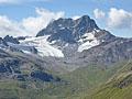
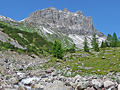
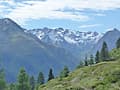
Fluela Pass to the Schwarzhorn ![]()
Distance: 4.6 miles (Round Trip)
Hike to the summit of the Schwarzhorn for splendid, panoramic views of the high peaks in the northeast Graubunden area and beyond. The Schwarzhorn is considered to be one of the easier 3,000-meter peaks to ascend in the Swiss Alps.
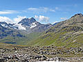
Fuorcla Surlej to Pontresina via Coaz Hut ![]()
Distance: 3.0 - 12.3 miles (One Way)
Glorious, panoramic views of Piz Bernina and Piz Roseg from Fuorcla Surlej, front row seats to an incredible spectacle of rock and ice from Coaz Hut and a lovely walk through the beautiful meadows and forests of Val Roseg make this one of my favorite hikes in the St. Moritz area.
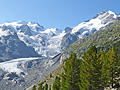
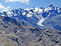
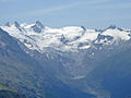
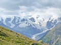
Morteratsch Glacier and Boval Hut ![]()
Distance: 6.7 - 8.0 miles (Round Trip)
The hike to the Boval Hut enjoys breathtaking views of the dramatic glacial cirque at the head of the Morteratsch Valley, dominated by the Piz Palu and Bernina massifs along with the Morteratsch and Pers glaciers.
Distance: 7.3 - 9.2 miles (Loop)
This loop hike ascends thorough lovely meadows to the overlook at Mout da l’Hom and then the summit of Piz Clunas with panoramic views of the high peaks towering above the Lower Engadine Valley and beyond.
Distance: 6.8 - 10.4 miles (One Way)
Panoramic views of rugged peaks, two beautiful valleys and a chance to see wildlife are the scenic rewards of this great hike, one of the best in the Swiss National Park, visiting Val Minger and Val Plavna.
Distance: 7.0 - 8.0 miles (One Way)
The Munt la Schera trail, in the Biosfera Val Mustair and the Swiss National Park, ascends through scenic meadows sprinkled with wildflowers to the broad summit of Munt la Schera where panoramic views extending to the summits in the Swiss National Park, Italy’s Stelvio National Park and beyond.
Distance: 8.4 miles (Round Trip)
Ascend a bucolic valley and then scree-covered slopes to scenic Sertig Pass with terrific views of the cirque rimming the Tschuvel Valley. Along the way enjoy fine views of the summits rimming the Ducan and Chuealp valleys including the Mittaghorn, Chuealphorn and Bocktenhorn.
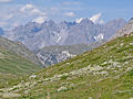
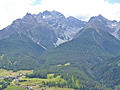
Guarda to Ardez via Furcletta Pass ![]()
Distance: 9.0 - 13.5 miles (One Way)
This long, demanding hike visits three scenic valleys and crosses a panoramic pass with splendid views of the high peaks of the Silveretta and Engadine Dolomite Alps.
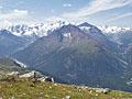
Muottas Muragl to Alp Languard ![]()
Distance: 4.0 - 6.0 miles (One Way)
A short hike that is long on panoramic views of the high peak towering above the Roseg, Morteratsch and Upper Engadine valleys. Extend the hike with a high traverse beneath the ridge anchored by Piz Muragl and Piz Languard for great views of the Bernina massif.
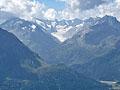
Davos Panoramaweg - Gotschnagrat to Schatzalp ![]()
Distance: 4.7 - 11.5 miles (One Way)
The Davos Panoramaweg, a classic high traverse above the west side of the Davos Valley, features great views of the high peaks and glacier clad summits towering above the Davos, Klosters, Fluela, Dischma and Sertig valleys.

Distance: 3.0 - 8.3 miles (One Way)
This quintessential Engadine hike is renowned for the dramatic views of glacier-clad Piz Bernina and Piz Roseg towering above Val Roseg. Lovely meadows, pretty larch forests and a rushing river add to the scenic delights on the descent to the valley floor and then Pontresina.
Distance: 2.5 - 8.9 miles (Round Trip)
An easy to moderate walk up the beautiful, pristine Fex Valley visits charming villages set amid lovely meadows. Along the way enjoy wonderful views of the high peaks rising above the northwest side of the Upper Engadine Valley and the glacier-clad cirque at the head of the valley.

Distance: 7.1 - 10.0 miles (One Way)
The hike to Val Fedoz, a secluded hanging valley, travels through lovely meadow with wonderful views of the cirque at the head of the valley and the surrounding peaks.
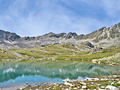
Distance: 12.0 - 12.7 miles (Round Trip)
This trail ascends the Zeznina Valley to the gorgeous Macun Lakes in the Swiss National Park. The glacial lake basin lies nestled beneath a rugged cirque high above the Lower Engadine Valley. Extend the hike with a challenging climb to the Baselgia Ridge and a very steep descent to Zernez.
Distance: 4.5 miles (Round Trip)
The Segantini Hut, high above Pontresina in the Bernina Valley, offers birds-eye-views of the summits soaring above the Roseg, Morteratsch and Upper Engadine Valleys.
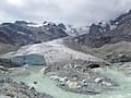
Distance: 3.6 - 5.0 miles (Round Trip)
Learn about how receding glaciers change a landscape on this hike to the Morteratsch Glacier. After an easy stroll up the valley floor, the path turns rugged, climbing to a spectacular viewpoint of the glacial tongue framed by the soaring peaks of the Bernina range.
Panorama Trail - Muottas Muragl to Alp Languard ![]()
Distance: 4.3 miles (One Way)
The Panorama Trail, an easy traverse between Muottas Muragl and Alp Languard, features nearly nonstop views of the Upper Engadine and Bernina Valleys. Highlights include alpine meadows, glacier-clad peaks, and broad panoramas of the Albula and Bernina Alps.
Wagerhus - Jorifluelafurgga - Berghaus Vereina ![]()
Distance: 6.0 miles (One Way)
Stunning views of the Joriseen lakes, the Fluela Wisshorn and Jori Glacier await hikers climbing to Jorifluelafurgga. From the pass the trail descends to a beautiful lake basin and then drops down the lovely, untamed Jori Valley, ringed by high peaks, to the Berghaus Vereina.
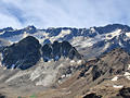
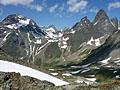
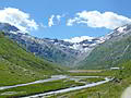
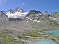
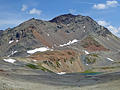
Durrboden to Fuorcla da Grialetsch and Fuorcla Radont ![]()
Distance: 4.8 - 7.7 miles (Round Trip)
Two scenic passes and views of the high peaks towering above four beautiful valleys are the highlights of this trail climbing from Durrboden to Fuorcla da Grialetsch and Fuorcla Radont. Along the way the trail passes by pretty tarns and enjoys fine views of the Scaletta and Grialetsch Glaciers.
Distance: 6.4 - 7.6 miles (Round Trip)
Skip the crowds on this great hike that travels through Alp Munt, visits lovely Lake Sgrischus and then climbs to a panoramic overlook atop Piz Chuern with views of the Corvatsch massif and the high peaks towering above the Fex, Fedoz and Upper Engadine valleys.
Julier Pass to Fuorcla Grevasalvas to Maloja ![]()
Distance: 5.2 - 8.4 miles (One Way)
Two pretty lakes, a panoramic pass and lovely views of the Albula and Bernina Alps are the scenic rewards of this hike crossing the rugged range between Julier Pass and the Upper Engadine Lakes plateau.
Val Sesvenna and Fuorcla Sesvenna ![]()
Distance: 8.6 - 10.2 miles (Round Trip)
Ascend the Sesvenna Valley to a rocky, meadow-clad bowl accompanied by fine views of the peaks and summits rising to the west. Extend the hike with a very steep climb to Sesvenna Pass with stunning vistas of the rugged Sesvenna cirque and the summits towering above the S-charl Valley, the Swiss-Italian border and beyond.
Alp Languard to Fuorcla Pischa ![]()
Distance: 6.7 miles (One Way)
Get off the beaten path with this scenic hike climbing to Fuorcla Pischa, a high pass at the head of Val Languard. The hike enjoys great views of the glacier clad Bernina massif, Piz Languard and the stark basin, sprinkled with tarns, below Pischa Pass.
Davos Alpentour – Glaris to Schatzalp ![]()
Distance: 10.8 miles (One Way)
This lovely walk traverses above or near the timberline along the west side of the Davos Valley with fine views of the peaks towering above the east side of the valley and the summits rimming the ridge to the west. Alternative destinations allow hikers to easily shorten the walk.
Distance: 7.2 - 7.7 miles (One Way)
Get off the beaten path with this great hike ascending the Ducan Valley to Fanezfurgga Pass. Highlights include the Ducan Ridge, Ducan Glacier and the Chrachenhorn towering above the head of the Ducan valley. Finish the hike by descending the pretty Oberalp Valley to Monstein.
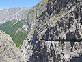
Distance: 12.4 miles (Round Trip)
This trail, popular with hikers and mountain bikers, ascends through forest and then the meadows of Alp Dadaint before traveling through the dramatic Uina Gorge, a narrow chasm between two sheer rock walls.

Distance: 5.6 - 11.6 miles (Round Trip)
Val Trupchun is one of the best wildlife viewing areas in the Swiss National Park, offering hikers the chance to observe red deer, ibex, chamois, and marmots in a pretty valley to the east of S-chanf.
Distance: 6.8 - 9.4 miles (One Way)
This scenic traverse along the north side of the Lower Engadine Valley combines great views of the valley's high peaks with lovely rambles through pretty villages with traditional Engadine homes decorated with sgraffiti.
Distance: 6.8 - 8.4 miles (One Way)
Forested slopes, expansive meadows and the pretty Clemgia River, meandering down a scenic valley beneath rugged peaks and rounded mountains, are the hallmarks of this hike up the S-charl Valley to Fuorcla Funtana da S-charl, a broad pass overlooking the S-charl and Mustair Valleys. End the hike by descending into the Mustair Valley to Ofenpass (Pass dal Fuorn in Romansh).
Rinerhorn (Jatzmeder) to Sertig ![]()
Distance: 4.5 miles (One Way)
This beautiful half-day hike, through meadows and forests, showcases the high peaks rising above the Landwasser Valley and the summits soaring above the head of the scenic Sertig Valley, including the Mittaghorn, Plattenflue and Piz Ducan.
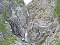
Distance: 1.8 miles (Round Trip)
Easy hike up the lovely Sertig Valley beside a rushing stream to the dramatic Ducan Waterfall tumbling down a rugged chasm in three stages.
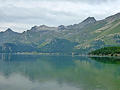
Lakes Trail: Silvaplana to Maloja ![]()
Distance: 3.3 - 7.9 miles (One Way)
This delightful walk traverses the eastern shores of Lake Silvaplana (Silvaplanersee) and Lake Sils (Silsersee) with lovely views stretching across the lakes to the high peaks towering above the Upper Engadine Valley.
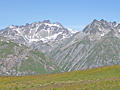
Distance: 5.2 miles (Round Trip)
The trail to Scaletta Pass ascends through pastures, rocky meadows and then scree covered slopes with ever evolving views of high summits surrounding the photogenic valley. Highlights include the glacier-clad Scalettahorn, the Fluela Schwarzhorn massif and the peaks towering above Fuorcla da Grialetsch.
Alp Languard to Chamanna Paradis and Lake Languard ![]()
Distance: 2.3 - 4.3 miles (Loop)
A short but rewarding climb to Paradis Hut delivers panoramic views of the Bernina peaks, Albula Alps, and surrounding valleys in just over a mile. Extend the day by hiking to Lej Languard, a tranquil lake nestled beneath rugged peaks at the head of the Languard Valley.
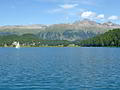
Distance: 2.8 miles (Loop)
The short, easy walk around Lake St. Moritz features fine views of St. Moritz and some of the high peaks rising above the Upper Engadine and Bernina Valleys.

St. Moritz to Lake Staz to Celerina (or Pontresina) ![]()
Distance: 4.0 - 8.4 miles (Round Trip)
The short, easy hike to lovely Lake Staz (Stazersee / Lej da Staz) offers mountain views, a restaurant, picnic spots, a playground, and swimming in warmer months. The path is suitable for everyone with connecting trails allowing hikers to easily visit Celerina or Pontresina.
| Support our Site |
The Region, the Hikes & the Base Camps
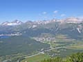
This area including the Engadine and Davos, offers a multitude of great hiking trails from easy walks along beautiful lakes to moderate jaunts between the rustic villages. Strenuous hikes climb over scenic passes with stunning views of glacier-clad peaks and travel up tranquil valleys amid rugged peaks. Home to the country’s only national park near Scuol along with the jet-set ski-resorts of St. Moritz and Davos, this area offers a little something for everyone.
Base Camp Information:
St MoritzScuolDavos