Best Hikes in Ouray, Colorado
Location: Southwest Colorado
On Highway 550, 35 miles south of Montrose, CO and 70 miles north of Durango, CO.
By: Diane Greer
Ouray's close proximity to some of the regions great hikes makes the pretty little Victorian town a perfect base camp for outdoor enthusiasts... View Ouray Info
Introduction
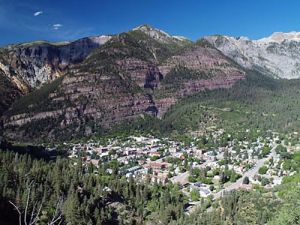
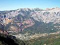
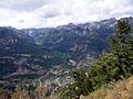
Ouray (7,746-ft.) is a pretty little Victorian mountain town nestled beneath a dramatic granite amphitheater and surrounded by 12,000-ft. plus peaks. A variety of accommodations and services along with its close proximity to some of the regions great hikes makes the town a perfect base camp for outdoor enthusiasts.
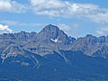
The town is located in the heart of the Uncompahgre National Forest in southwest Colorado, 35 miles south of Montrose and 70 miles north of Durango, CO on Highway 550. Distinctive Mt. Sneffels (14,150-ft.), rising to the west of town, is the center piece of the 16,500-acre Mt. Sneffels Wilderness. Northeast of Ouray is the 99,000-acre Uncompaghre Wilderness, home to two 14ers, Wetterhorn Peak (14,015-ft.) and Uncompahgre Peak (14,309-ft.) along with numerous peaks over 13,000-ft.
Ouray Hiking Trails
Distance: 7.8 - 8.2 miles (Round Trip)
Difficulty: strenuous
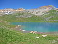
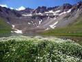
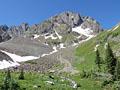
This wonderful hike visits two gorgeous lake basins, traverses wildflower-filled meadows and passes numerous waterfalls. Dramatic peaks punctuate the ridge forming the backdrop for upper Ice Lake, nestled in an alpine wonderland that invites exploration.
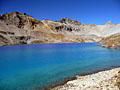
Blue Lakes and Blue Lakes Pass ![]()
Distance: 6.3 - 11.0 miles (Round Trip)
Difficulty: moderate-strenuous
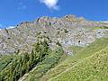
This popular hike visits three scenic lakes nestled in beautiful glacial basins set amid rugged ridges and peaks. Beyond the lakes the trail climbs to a dramatic pass on a ridge south of Mt. Sneffels (14,150-ft).
Bear Creek National Recreation Trail ![]()
Distance: 4.4 - 8.0 miles (Round Trip)
Difficulty: moderate-strenuous
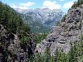
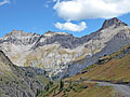
A dramatic trail carved into a steep cliff face high above Bear Creek is just one of the highlights of this hike up a beautiful canyon to two scenic mine sites.
Distance: 7.0 - 8.9 miles (Round Trip)
Difficulty: strenuous
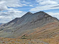
This little known hike climbs steeply through forest and beautiful alpine meadows to a stunning glacial lake set amid a backdrop of rugged 13,000-ft. peaks. Panoramic views from nearby Columbine Pass encompassing Bridal Veil Basin and the Sneffels Range.
Distance: 5.0 - 7.0 miles (Round Trip)
Difficulty: moderate
This scenic hike climbs to two pretty lakes in gorgeous Porphyry Basin. Along the way the trail travels through wildflower-filled meadows and passes waterfalls, interesting rock formations and mining ruins. The lovely alpine meadows of the upper basin offer several options for off-trail exploration.
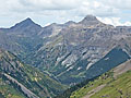
Distance: 6.2 - 11.0 miles (Round Trip)
Difficulty: moderate-strenuous
View of Dunsinane Mountain, Precipice Peak, Redcliff Peak and Coxcomb Peak accompany hikers on this long hike up the scenic Middle Fork Cimarron Valley. A final steep climb leads to Middle Fork Pass with spectacular views of Uncompahgre, Wetterhorn and Matterhorn Peaks.
Distance: 5.8 - 9.0 miles (Round Trip)
Difficulty: moderate
This trail wanders through wildflower-filled meadows and then climbs a gorgeous alpine basin to West Fork Pass. From the pass the trail drops into scenic Wetterhorn Basin with view of Wetterhorn Peak (14,015-ft.).
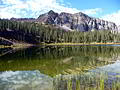
Distance: 11.0 - 11.8 miles (Round Trip)
Difficulty: moderate
A scenic hike to a pretty lake nestled beneath North Twilight Peak (13,075). The hike can be extended by hiking to the saddle beyond the lake and/or scrambling to the top of North Twilight.
Distance: 5.2 - 7.0 miles (Round Trip)
Difficulty: moderate
This pretty trail travels along an old mining road through three wildflower-filled basins accompanied by grand views of the Red Mountains towering above the west side of the Million Dollar Highway. Ruins of the Barstow and Greyhound mines add interest to the walk.
Distance: 5.6 miles (Round Trip)
Difficulty: strenuous
Terrific views of the high peaks towering above the Million Dollar Highway and Yankee Boy Basin are the rewards of this steep climb to a scenic pass to the south of Hayden Mountain.
Bridge of Heaven (via the Horsethief Trail) ![]()
Distance: 8.0 miles (Round Trip)
Difficulty: strenuous
This well-engineered trail ascends 3,000-ft. to a knife-edge ridge with spectacular panoramic views.
Distance: 6.8 - 8.2 miles (Round Trip)
Difficulty: moderate
This is a good hike for people looking for solitude and dramatic, up-close views of Mt. Sneffels. Don’t let the crowded parking lot deter you. Most hikers are headed for the Blue Lakes basin. You will have the Blaine Basin trail mostly to yourself.
Distance: 5.0 - 6.6 miles (Round Trip)
Difficulty: strenuous
Great views of the peaks rising above Ironton Park are the rewards for this stiff climb up the east facing slopes of Hayden Mountain. A traverse below the Hayden Ridge then leads to a route ascending to Peak 12,578 with terrific views of Yankee Boy Basin.
Distance: 5.8 - 7.6 miles (Round Trip)
Difficulty: moderate-strenuous
Ascend a scenic jeep road into the heart of Governor Basin, explore the Mountain Top mine ruins and then follow a route to an overlook with impressive views of the high peaks of Yankee Boy Basin.
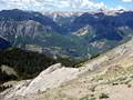
Distance: 5.2 miles (Round Trip)
Difficulty: moderate-strenuous
This nice half-day hike climbs on moderate to moderately-steep grades to a 12,450-ft. pass with panoramic views of the surrounding valleys and high peaks.
Colorado Trail: Little Molas Lake to Lime Creek ![]()
Distance: 7.4 - 10.1 miles (Round Trip)
Difficulty: moderate
A moderately easy hike along a segment of the Colorado Trail featuring panoramic views from the high meadows above the West Lime Creek valley.
Distance: 5.9 miles (Loop)
Difficulty: moderate
Ouray’s scenic Perimeter Trail circumnavigates the town, traversing cliffs, canyons and forested hillsides. Points of interest along the trail include Cascade Falls, the Baby Bath Tubs, the Amphitheater, the Uncompahgre River and Canyon Creek.
Distance: 3.5 - 4.2 miles (Round Trip)
Difficulty: easy
This short, easy loop hike explores the basin below a huge amphitheatre of eroded cliffs rising above the eastern side of Ouray and features scenic viewpoints to appreciate the formation along with the peaks rising to the south and west of town.
Distance: 6.0 - 7.0 miles (Round Trip)
Difficulty: strenuous
Nice views of Hayden Mountain, Whitehouse Mountain and the Uncompahgre River Gorge are the highlights of this hike up pretty Oak Creek Canyon to an overlook on the southern flank of Twin Peaks.
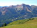
Distance: 6.8 - 7.9 miles (Round Trip)
Difficulty: moderate
The moderate hike to Baldy Peak features great views and an interesting perspective of the high peaks of the Ouray Region.
Distance: 5.6 miles (Round Trip)
Difficulty: moderate-strenuous
Hikers completing the stiff climb to an overlook 3,000-ft. above Ouray are rewarded with panoramic views of Ouray, the amphitheatre and the sea of peaks and ridges rising to the east of town.
Upper Cascade Falls / Chief Ouray Mine ![]()
Distance: 4.4 - 5.9 miles (Round Trip)
Difficulty: moderate-strenuous
This great half day hike climbing high above the eastern side of Ouray features fabulous views of the Uncompahgre Valley, Cascade Falls and the Amphitheatre.
View Hikes by Area:
Southwest ColoradoOurayTellurideSilvertonLake City
| Support our Site |
Around Town
During the day Ouray (pronounced “you-ray” by the locals) is a popular stop for sightseers driving the San Juan Skyway, a stunning 233-mile loop that crosses four high passes and connects Ouray to Silverton, Durango, Cortez, and Telluride (going clockwise around the loop). The Skyway’s steady stream of tourists helps support a good selection of restaurants, bars and breweries along with a range of accommodations that includes condos, cabins and vacations rentals, B&B’s, hotels/motels and campground/RV parks.
By 4pm the day trippers plying the scenic byways disappear and the town takes on a more laid back, family atmosphere. Be sure to spend at least one of your evenings strolling Ouray’s back streets admiring the beautifully restored Victorian architecture. The entire town is listed on the National Register of Historic Districts and most of its structures, built between 1880 and 1900 during the area’s mining boom, are still standing.
My favorite place in town is Ouray's Hot Springs. After a hard day of hiking nothing is better than soaking in the pools fed by natural hot springs while admiring the red sandstone and granite cliffs towering above town. The facility is configured into different pools ranging in temperature from 96-105 degrees and includes a cooler lap swimming section, diving area and kiddie wading pool. The adjacent park is a nice place for a picnic. The Ouray Visitor Center is located next to the facility.
A short walk in town to the end of east 8th Avenue will take you to the base of Cascade Falls, the lowest segment of a series of seven waterfalls draining snowmelt from the peaks above town. Box Canyon Waterfalls and Park, located on CR 361 off Highway 550 just south of Ouray, is an interesting geological formation featuring a 285-ft. waterfall plummeting through a narrow box canyon. It is worth the entrance fee and the hour or so spent viewing the formation and walking the three interpretive trails. Another nice walk is the Uncompahgre River trail, which starts on the west side of town just north of the Hot Springs and meanders along the river to Ouray's northern border.
The Ouray Perimeter Trail is a good option for visitors looking for a longer walk. The 5.9 mile trail, which can be accessed from several spots around town, visits Cascade Falls, the Baby Bathtubs and crosses over Canyon Creek’s spectacular gorge. Along the way enjoy great views of Mt. Abrams, Hayden Mountain, Whitehouse Mountain, Twin Peaks and the Amphitheater. An optional detour includes a visit to Box Canyon Park. A map and additional information about the Perimeter Trail is available at the Ouray Visitor Center.
Nearby Attractions
There is plenty to do around Ouray if you decide to take a day off from hiking. Most people drive the Million Dollar Highway, the 24 mile section of the San Juan Skyway between Ouray and Silverton. The route travels by jaw dropping scenery littered with mining relics and climbs over 11,018-ft. Red Mountain Pass. A full day needs to be allocated to drive the entire San Juan Skyway. This trip is better done as part of an extended trip with overnight stops in Silverton and Telluride.
Another interesting diversion is a trip to one of the area's ghost towns. A few are accessible with a passenger vehicle but most require a 4WD (tours are available). The Ouray Visitor Center located by the Hot Springs has a complete list of the options along with directions and recommendations.
Those with a 4WD and taste for adventure may want to drive the area’s famous backcountry roads. Yankee Boy Basin, to the southwest of town, provides opportunities to visit several ghost towns, view beautiful Twin Falls and, during late July/early August, see spectacular displays of wildflowers. The Alpine Loop is another popular route leading over 12,000-ft passes to the Lake City and back. Be sure to check with the local tourism office about road conditions and the skill level required to drive each of the routes.
A tour of the Bachelors Syracuse Mine is a good option for a rainy day. (See also Old Hundred Gold Mine Tour outside of Silverton.) A guide with experience working the mine takes visitors 1,800 feet horizontally into Gold Hill to a work area used to extract the silver and other minerals. The tour includes a complete presentation of the equipment and techniques used to extract the ore.
Food, Lodging and Services
Just about all the basic services you need are found along Main Street, a six block section of Highway 550 running through the center of town. The Ouray Visitor Center, open 7 days a week during the summer, is located at 1230 Main Street, next to the Hot Springs Pool. The Ouray Visitor website includes lists of area accommodations, restaurants, bars and breweries.
The Ouray Grocery, a small grocery at 621 Main Street, offers the basics for making a meal. Those looking for a wider selection should travel 11 miles north to the Ridgway Mountain Market (490 Sherman St, Ridgway) or purchase groceries in Montrose or Durango. Coffee along with a great selection of chocolates is available at Mouse's Chocolates and Coffee (520 Main Street). Ouray Mountain Sports (732 Main St.) stocks clothing and gear for climbers and hikers. A surprisingly good selection of maps, guides and leisure reading material can be found at Buckskin Booksellers at 505 Main St.