Togwotee Pass Information
Location:
On U.S. Highway 287 and U.S. Highway 26, 25 miles east of Moran Junction and 30 miles northwest of Dubois.
Introduction
Togwotee Pass is located on the Continental Divide in the southern Absaroka Mountains, between Moran Junction, Wyoming (in the Jackson Hole Valley) and Dubois, Wyoming. U.S. Highway 287 and U.S. Highway 26 cross the pass, which is located 25 miles east of Moran Junction and 30 miles northwest of Dubois.
All Togwotee Pass Hikes
Best Togwotee Pass Hikes
Jade Lakes, Upper Brooks and Rainbow Lake ![]()
Distance: 5.5 - 8.3 miles (Round Trip)
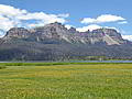
Multi-hued volcanic cliffs towering over 1,000-ft. above a quintet of pretty lakes are the stars of the show on these scenic hikes in the Brooks Lake area in the southern Absaroka Range, located to the east of the Tetons.
Distance: 5.5 miles (Round Trip)
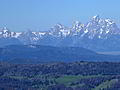
An unsigned trail leads to a route climbing to Breccia Peak where stunning views encompass the Tetons, the southern Absaroka Mountains and the Wind River Range. Closer at hand are terrific views of the North Breccia Cliffs and the Cub Creek drainage.
Distance: 5.2 miles (Round Trip)
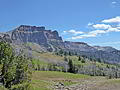
This short trail leads to the beautiful meadows of Bonneville Pass with nice views of Pinnacle Buttes and the volcanic peaks and cliffs rising above the Brooks Lake area and the Dunoir Valley, located to the northeast of the Tetons.
Distance: 5.6 - 9.5 miles (Round Trip)
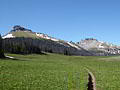
Solitude, lovely meadows and great views of the volcanic formation around the Togwotee Pass area are the highlights of this hike through in the southern Absaroka Mountains, located to the northeast of the Tetons.
View Hikes by Area:
Grand Teton NPJackson HoleDriggsTogwotee Pass
Back to All Togwotee Pass Hikes