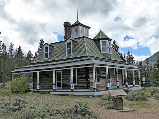
Dexter's Cabin
This easy hike traversing the south shore of Twin Lakes leads to Interlaken, an interesting historic site once home to a popular luxury resort during the late 1800’s. From the resort and trail along the lake enjoy fine views of Twin Lakes, Mt. Elbert (14,433-ft.) and the surrounding peaks.
- Distance: 4.7 miles (RT)
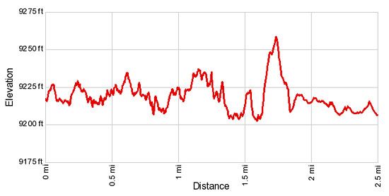
- Elevation: 9,230-ft. at Trailhead
Maximum elevation - 9,272-ft. - Elevation Gain: 42-ft.
- Difficulty: easy
- Basecamp: Buena Vista / Leadville
- Region: Central Colorado
Trail Description - Interlaken
During its heyday in the late 1800’s, the Interlaken Hotel complex was a popular resort for the wealthy. Visitor’s rode the train to a nearby station and then took a short carriage ride to the luxury summer retreat on the south side of Twin Lakes.
Today a section of the Colorado Trail, starting at the southeast end of the larger of the Twin Lakes, leads to the resort’s restored buildings, offering an opportunity for hikers to explore an interesting chapter of the area’s local history.
James Dexter, who purchased the hotel and grounds in 1883, enlarged and upgraded the facility to include a log tavern, pool hall, a dance hall, guest rooms with panoramic views, stables, a barn, an ice house and a six-sided privy that accommodated 6 guests in separate rooms. Dexter’s cabin, constructed in the mid-1890’s, is the most interesting structure on the property. The house, surrounded by open verandas, features imported wood trim, gabled dormer windows, a mansard roof and is topped with a glass enclosed cupola with views in all directions.
The resort operated for 25 year before it fell out of favor and closed in the early twentieth century. Contributing to the downfall was the transformation of Twin Lakes, a pair of glacial lakes, into a large reservoir. The reservoir’s dam, built in 1896, raised the level of the lakes, flooding the only road to the facility.
In 1970 plans to expand the reservoir and build a higher dam threatened to submerge some of resort’s structures. Thankfully the site had been placed on the National Register of Historic Places. After the completion of the dam several of the structures, including the hotel and Dexter's cabin, were saved from the rising waters by moving them 150-ft. to higher ground.
In 2004 local volunteers started a four-year effort to stabilize and restore the resort's structures. Today visitors are allowed to explore the site and wander by the preserved buildings, including the hotel, cabin, granaries and six-sided privy. Dexter's Cabin is open, permitting hikers to see the restored interior and view the lake from the cupola. The stable, which contain the remains of some old carriages and other relics, is also open.
The hike to Interlaken starts at the southeast end of the largest of the Twin Lakes. (See driving directions.) From the parking area the Colorado Trail heads west on easy grades through trees on an undulating path along the south side of the largest (lower) Twin Lake. Openings in the trees offer fine views of the lake, Mt. Elbert (14,433-ft.) towering above the north side of the valley and the peaks rising to the east.
At 1.3 miles reach a junction. Here the Colorado Trail East, which travels along the eastern side of the Collegiate Peaks, branches to the left (south/southeast). We continue straight ahead on the Colorado Trail West.
At 1.5 miles the trail briefly turns to the right (north) as it climbs a hill. Here nice views open to the peaks rising to the east. Soon the trail turns left (west), crests the hill and then drops down to cross a stream on a wood bridge at 1.9 miles.
Beyond the bridge the trail travels on mostly level grades, reaching Dexter's Cabin at 2.2 miles. The log structure with a mansard roof, dormer windows and a cupola, sits in a meadow with wonderful views of the lake and surrounding peaks. An information board outside the cabin offers a brief history of the site.
Enter the cabin through the front door facing the lake. (Be sure to latch the door when you leave.) The restored interior features walnut woodwork and beautiful wood floors. In its day the house was outfitted with beautiful bird's-eye maple furniture, lavish rugs and high-end decorations. Climb the steps to see the second floor rooms and then ascend the steep, narrow stairs to the cupola (watch your head) for birds-eye views of the lake.
The stable are also open for exploration. Go around the back of the structure and enter through the sliding door. A few old carriages and other relics are now stored in the stable.
When you are done visiting Dexter's Cabin and the stables explore the rest of the site. It is amazing how many buildings still stand. One of my favorites is the privy with doors on each of the structures six sides leading to private rooms.
As you wander around the resort be sure to walk to the meadows to the west of the resort for great views of Mt. Hope (13,953-ft.) and Rinker Peak (13,783-ft.) to the southwest. The Colorado Trail west continues beyond the resort along the south side of the second lake and eventually climbs Hope Pass.
When you are done exploring the historic resort retrace your steps to the trailhead. Total round trip hiking distance, including roaming around the site, is 4.7 miles. Even though the trail is relatively flat, there are quite a few ups and downs that add up to almost 760-ft. of elevation gain (round trip).
This is a good hike for families and parties looking for an easy half day walk. It is also a good option when bad weather precludes walking in the high country.
Elevation Profile
Driving Directions
Driving Direction from Buena Vista: From the traffic light at the intersection of US 24 and Country Road 306 in downtown Buena Vista, head north on US 24 W for 19.2 miles and turn left (west) on CO 82 W. Drive 0.8 miles on CO 82, past Lost Canyon Road and turn left (south) on CR 25, a dirt road across from a log structure. Follow CR 25 for 0.5 miles to an intersection south of the Twin Lakes dam. Turn left at the intersection and continue along CR 25. Follow CR 25 for 0.1 miles and turn right at the second dirt road. Follow this road for 0.3 miles to the Colorado Trail parking area on the left side of the road. (Beyond the parking area the road drops down to the lakeshore.)
Note: Passenger cars, under good conditions, can make it all the way to the trailhead. Otherwise, park at the wide area on the road just south of the dam and then walk to the trailhead.
From Leadville: From the intersection at 6th Street and Harrison (US 24), head east on US 24 E for 15 miles and turn right (west) on CO 82 W. Drive 0.8 miles on CO 82, past Lost Canyon Road and turn left (south) on CR 25, a dirt road across from a log structure. Follow CR 25 for 0.5 miles to an intersection south of the Twin Lakes dam. Turn left at the intersection and continue along CR 25. Follow CR 25 for 0.1 miles and turn right at the second dirt road. Follow this road for 0.3 miles to the Colorado Trail parking area on the left side of the road. (Beyond the parking area the road drops down to the lakeshore.)
Note: Passenger cars, under good conditions, can make it all the way to the trailhead. Otherwise, park at the wide area on the road just south of the dam and then walk to the trailhead.
Trail Resources
- Trail Photo Gallery
- Trail Maps
- Basecamp(s) Information: Buena Vista / Leadville
- Region Information: Central Colorado
- Other Hiking Regions in: Colorado