Details: See Forever - Bear Creek Loop 
Distance: 5.5 - 8.4 miles (loop)
Uncompahgre National Forest, near Telluride in Southwest Colorado
Hike Facts
- Distance: 5.5 - 8.4 miles (loop)
- Elevation: 10,540-ft. - 12,100-ft.
- Elevation Gain: 1,560-ft.
- Difficulty: strenuous
- Trail Highlights: See Trail Intro
- Basecamp(s): Telluride
- Region: Southwest Colorado
This interesting loop hike features panoramic views of Telluride, Bear Creek Canyon and the distant peaks of the Lizard Head Wilderness.
Trailhead to the junction with the Wasatch Connector Trail
Distance from Trailhead: 5.5 miles (round trip)
Ending/Highest Elevation: 12,100-ft.
Elevation Gain: 1,560-ft.
While the trail can be hiked in either direction, I recommend starting at the St. Sophia gondola station at 10,540-ft. and hiking in a counter-clockwise direction (see driving directions). This starting point limits the elevation gain to 1,540-ft. versus the alternative start at Bear Creek that involves a 3,280-ft gain.
Telluride’s free gondola links the town of Telluride with the Mountain Village, located south of town behind the San Sophia ridge. The St. Sophia station is an intermediate stop on the gondola, providing access to hiking, biking and ski trails.
Exit the gondola station and walk south for 0.4-miles, following a gravel ski access road uphill to a snowmaking pond. The start of the See Forever trail is marked by a Forest Service sign on the left side of the road just past the south end of the pond.
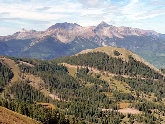
The trail traverses a tree covered hillside to the See Forever ski run, where a series of steep steps climb the western side of the run to a junction with the Lookout ski trail that heads downhill to Telluride. While climbing the steps enjoy wonderful views of the peaks and ridges rising to the north and northeast of Telluride. To the west are distance views of the San Miguel Mountains and the Lizard Head Wilderness.
At the junction the hiking trail crosses to the eastern side of the ski slope where a sign with a photograph identifies the peaks to the north/northeast. After taking in the views follow the trail, now on the eastern side of the See Forever run, as it continues its steep ascent.
At 1.2 miles signs for the See Forever hiking trail direct you to follow a gravel ski road, which switchbacks steeply up the ridge. The views of Lizard Head and the peaks to the north of Telluride help you ignore that you are walking through a ski area on a road.
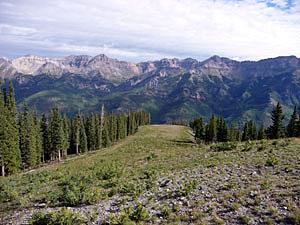
At 1.8 miles the grade abates a bit. Be sure to watch for the trail signs directing you to stay right at the intersection of two ski roads. (The road to the left heads to the top of a ski lift). A short distance beyond the intersection views open to the east (your left) to the cliffs lining the eastern wall of Bear Creek canyon.
Continue following the road as it climbs the ridge to meet the Wasatch Connector trail, which branches left from the road at 2.75 miles. At this point it is worth following the ski road for a short distance to a crest on the ridge. This section of the trail enjoys wonderful 360-degree views of the surrounding area. The 14,000-ft. peaks of the Lizard Head Wilderness dominate the skyline to the west. To the north the peaks and ridges of the Sneffels range tower above Telluride. To the east are the sculpted and highly eroded walls of the Bear Creek drainage while to the southeast Wasatch Mountain and the San Joaquin Ridge rise above the East Fork of the Bear Creek basin. Directly to the south a steep road climbs over 300-ft in 0.3-miles to the top of Gold Hill.
Wasatch Connector Trail to the junction with the Wasatch Trail
Distance from Trailhead: 1.5 miles (one way)
Ending/Highest Elevation: 11,530-ft.
Elevation Gain: -570-ft.
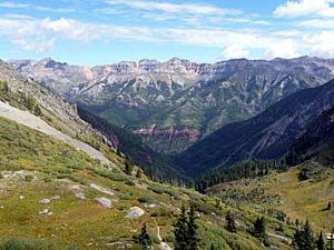
If you wish to do the loop hike after soaking in the scenery, head back to the Wasatch Connector and follow the trail as it traverses the Revelation ski bowl below Gold Hill. At 3.1 miles the trail crosses a minor ridge, leaving the ski area behind, and starts a steep descent on a rocky trail that loses 570 feet in a little over a mile. Views of Bear Creek canyon, the East Fork/Wasatch basin and the Telluride valley make it hard to keep your eyes on the narrow trail.
The connector trail ends at Bear Creek and the Wasatch trail at 4.2 miles> Here a sign points back to the ski area and across the basin to the upper portion of the Wasatch trail, which crosses the creek and ascends a grassy hillside on the other side of the drainage.
Wasatch and Bear Creek Trails back to Telluride
Distance from Trailhead: 8.4 miles (loop)
Ending/Highest Elevation: 8,820-ft.
Elevation Gain: -2,710-ft.
Look for a sign that simply says “trail” pointing north (downhill) on the west side of Bear Creek. This is the section of the Wasatch trail we will descend to meet the Bear Creek trail, which will take us back to Telluride.
At the trail junction Bear Creek drops steeply down a rocky gorge. To circumvent the gorge, the narrow Wasatch trail contours north along the hillside, staying high above the creek for 0.75 miles, then drops steeply down to the creek on switchbacks, losing 500-ft in about 0.5 miles. The trail meets the creek just above the junction with the East Fork Bear Creek trail. (The East Fork Bear Creek trail climbs the eastern side of the East Fork to meet the Wasatch trail in 0.9 miles in the upper East Fork/Wasatch basin.)
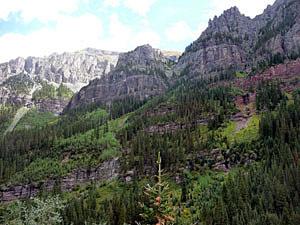
Continue following the Wasatch trail downhill. In a short distance you will pass the remnants of the Nellie mine on your left. Beyond the mine the trail descends a steep gully, then traverses the western canyon wall high above the creek. This scenic section of the trail offers great views of the cliffs towering above the canyon.
The final leg of the Wasatch trail drops steeply on switchbacks through groves of aspen and mixed conifers to the junction with the Bear Creek trail at 6.4 miles. While descending the final set of switchbacks look up canyon for nice views of beautiful Bear Creek Falls. (A 0.6 miles round-trip detour leads from the trail junction to a viewpoint near the base of the falls.)
The rest of the 2.0-mile walk is a breeze, following a wide dirt track descending the western side of the Bear Creek drainage back to Telluride at 8.4 miles. See the Bear Creek trail description for more information.
Note: The loop hike loses 3,280-ft in elevation from the start of the Wasatch Connector trail at 12,100-ft. to the beginning of the Bear Creek trail at 8,800-ft.
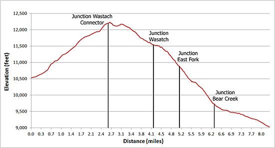
Elevation Profile
| Buy the BookThis opinionated guide includes all the hikes in the Ouray, Telluride, Silverton and Lake City sections of the website plus info on local services and nearby attractions. |

Driving Directions
Directions to the St. Sophia Gondola Station from Telluride: In Telluride walk to the gondola located on San Juan Avenue between S. Aspen and S. Oak Street, 3 blocks south of Colorado Avenue (main street). Take the free gondola to the St. Sophia station. From the gondola station, walk south on the Nature Trail for about 200 yards to the log cabin. Continue on the adjacent road (Basin Road/Trail) for approximately 300 yards as it proceeds south past the Village Trailhead sign to the snowmaking pond and See Forever Trailhead sign on the left.
Directions to the Bear Creek Trail from Telluride: From Telluride's main street (Colorado Avenue), turn south onto Pine Street and walk 4 blocks. After crossing the river the street turns into a dirt road that becomes the Bear Creek Trail.
Note: Parking in Telluride can be difficult. Parking is by permit only on many of the streets in the residential section of town and is limited to two-hour parking along Colorado Avenue and its adjacent side streets. Free day-use parking is available in Carhenge Lot, just off West Pacific Avenue at the west end of town near the base of Lift 7, or at the south end of Mahoney Drive near the west entrance to town. A free shuttle bus called the Galloping Goose runs between the parking lots and various stops in downtown Telluride.
There is also free parking in the mountain village. From there you can take the free gondola to/from the St. Sophia Gondola Station and town.
Trail Resources
Trail Intro / Trail Photo Gallery / Trail Map
Basecamp(s) Information:
Telluride
Region Information:
Southwest Colorado
Other Hiking Regions in:
Colorado