Details: Phipps Arch 
Distance: 8.8 - 10.4 miles (round trip)
Grand Staircase–Escalante National Monument, near Escalante in South Central Utah
By: Diane Greer
Hike Facts
- Distance: 8.8 - 10.4 miles (round trip)
- Elevation: 5,710-ft. - 5,570-ft.
- Elevation Gain: -140-ft.
- Difficulty: moderate-strenuous
- Trail Highlights: See Trail Intro
- Basecamp(s): Escalante
- Region: South Central Utah
This scenic hike visits an interesting arch set high atop the north wall of Phipps Wash. An optional extension travels to Maverick Bridge.
To Phipps Arch
Distance from Trailhead: 8.8 miles (round trip)
Ending/Highest Elevation: 5,570-ft.
Elevation Gain: 475-ft.
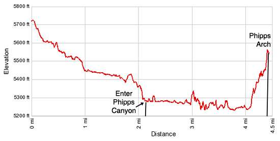
Note: The elevation gain and loss is more than indicated in the trail statistics. The trailhead is at 5,710-ft. The low point of the hike is at 5,235-ft. From that point the trail climbs to Phipps Arch at 5,570-ft.
This is an unmarked route. The last time I hiked the trail all the rock cairns marking the bypass trails and route up to the arch had been knocked down/removed. Hikers should be comfortable with route finding and climbing up and down steep slickrock friction pitches. There is a shorter approach to the arch via the Escalante River that is not as scenic and requires getting your feet wet. (A description of the shorter hike can be found at the end of this trail guide.)
This description starts from a pullout on Utah 12 that is 11.4 miles east of Escalante, Utah. See the driving directions (below) for information on finding the pull out as well as starting the hike from the Old Sheffield Road.
From the pullout on the north side of Utah 12, carefully cross the highway and head south/southeast down a shallow canyon, nothing more than a draw at this point, that is a tributary of Phipps Wash. There is no trail here, simply follow the easiest path down the drainage across slickrock and sandy surfaces. Along the way you will plod through areas of soft sand. Where possible, walk along the exposed slickrock.
At 0.4 miles bypass a pour-off on the left (east). Rock cairns may mark the route. The route briefly traverses the slickrock slopes along the east side of the drainage before dropping back down to the wash. Make note of where you re-enter the wash so you can find the route on the return trip.
As you descend enjoy nice views of the multihued sandstone formations rising to the south/southwest of the wash. Closer at hand pass potholes carved in the wash by erosion forces.
Bypass a second pour-off on the right at 1.0 miles. Detour around the third pour-off on the left. Plunge pools beneath both pour-offs may hold water early in the season or after it rains.
Reach the top of the final pour-off, with a 75-ft. drop off, at 1.8 miles. Bypass this obstacle by ascending the slickrock slopes to the right (west) and then traversing a slickrock bench along the west side of the nascent canyon for 0.2 miles before dropping back into the wash. The descent back to the wash makes use of a sand dune along the west side of the canyon. Parts of this route may be marked by cairns.
Shortly after regaining the wash reach the confluence of the tributary canyon with Phipps Wash. Turn left (east) at the confluence and head down Phipps Wash.
Phipps is quite scenic with high sandstone walls stained with desert varnish towering above the wide, sandy wash. As you travel down the wash try to avoid the deep sand, walking where ever possible on exposed slickrock or packed sand paths. Along sections of the wash you will have no choice but to plod through the deep, soft sand.
At 2.6 miles the canyon curves to the north. Here both sides of the wash are flanked by richly hued sandstone walls.
The canyon constricts at 2.9 miles and soon pockets of water appear in the wash. The moisture supports a profusion of cottonwoods, junipers, willows, grasses and scrub growth. Follow the boot beaten paths that weave through the vegetation, crossing back and forth across the wash to find the path of least resistance down canyon.
At 3.5 miles a large alcove opens along the right (east) canyon wall. This is a good landmark to gauge your progress. Over the next three-tenths of a mile you will pass bays along the east and west canyon walls.
At 3.9 miles pass a short side canyon coming in from the west. Just beyond a major side canyon opens to the east at 4.0 miles. As the trail crosses to the right (east) side of Phipps wash, look for rock cairns marking a boot beaten path heading east into the side canyon. You may need to backtrack a bit to find the route. This is the trail to Phipps Arch.
In less than a tenth of a mile a boot beaten trail starts ascending steeply up the north wall of the side canyon. Rock cairns may mark the route as it climbs slickrock slopes and ledges. Otherwise you need to use your judgment. In places the boot beaten path simple ends. This is a good indication that you need to climb up to the next bench and then hunt around for the continuation of the boot beaten route.
Near the end of the climb the route turns left (north) into a short, sandy draw. Toward the head of the draw watch for cairns marking where the route climbs up a steep friction pitch on slickrock along the left side of the draw. If not cairns are present pick your own route out of the draw. At the top of the climb the route turns left and Phipps Arch springs into view. From the wash to the arch the trail gains about 335-ft. in just over 0.3 miles.
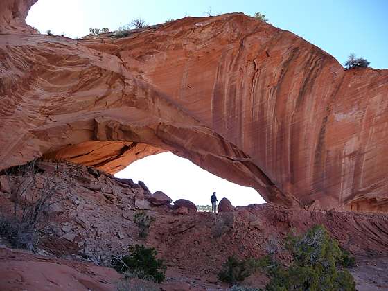
Phipps Arch which is 85-ft. wide and 26-ft. high, stands atop the canyon’s north wall surrounded by sandstone knobs. The arch was formed when the erosive forces of ice, wind, and water cut through the narrow sandstone ridge.
Take time to explore around the arch and enjoy the great views that extend west to the high sandstone plateaus around Escalante. Looking down enjoy a bird’s eye view of the multihued walls lining Phipps Canyon.
When you are done investigating the arch and enjoying the view, carefully retrace your steps to the canyon floor. You now have a few options. One is simply to return the way you came. The second is to continue down Phipps Wash to Maverick Bridge.
To Maverick Bridge
Distance from Trailhead: 10.4 miles (round trip)
Ending/Highest Elevation: 5,310-ft.
Elevation Gain: 475-ft.
To reach Maverick Bridge walk down the wash for a half mile and turn left (west) into the west trending side canyon. Walk up the canyon’s sandy wash. Soon you will see a boot beaten path ascending the bench to the left (southwest). Follow the path for a short distance to Maverick Bridge, a small narrow sandstone bridge that extends 15-ft. across the wash. Total walking distance from the wash below Phipps Arch is 0.8 miles.
Phipps Arch from the Escalante River Trailhead on Highway 12
Distance from Trailhead: 5.0 miles (round trip)
Ending/Highest Elevation: 5,570-ft.
Elevation Gain: 390-ft.
This 5.0 miles round-trip hike starts at the Escalante River Bridge trailhead on Highway 12, located 14.4 miles east of Escalante. (Turn left (west) into the signed trailhead parking lot.) From the trailhead, follow the signed trail 1.5 miles down the Escalante River to Phipps Wash, which enters on the right. (The path will cross the river a few times in-route to Phipps Canyon.)
The trail to Maverick Bridge is located in a small side canyon approximately 0.5 miles up the canyon on the right (west). The route to Phipps Arch is approximately 1.0 miles up Phipps Wash on the left (east). To reach the arch follow the trail that ascends steeply up the north wall of the side canyon, climbing slickrock slopes and ledges. Some rock cairns may mark the route. See the description above for more information on the hike up to the arch.
Elevation Profile
Driving Directions
From Escalante:
Option 1: From the intersection of Main Street and Center Street in downtown Escalante, drive east/southeast on Utah 12 E (Main Street) for 11.4 miles to a dirt/gravel pullout on the left (north) side of the road. Park here. The turnout is located 0.9 miles past the Old Sheffield Road, a short distance west of milepost 71. (Right after passing the Old Sheffield Road Utah 12 makes a sharp left turn and descends a steep hill via switchbacks. The pullout is located a short distance beyond the end of the switchbacks.) Note: I typically drive past the pullout and find a safe place to turn around further east along Highway 12 before driving back to and parking at the pullout.
Option 2: Drive 10.0 miles east of Escalante on Utah 12 E. Turn right (south) onto the Old Sheffield Road (103). The road is located just beyond mile posts 70 and just before Utah 12 makes a sharp left turn. (This dirt road connects with Hwy 12 approximately 0.5 mile past the Head of the Rocks Overlook.) There are several possible places to start the hike off of the Sheffield Road. A good place is 0.75 mile south of Hwy 12 at a dispersed camping site on the left (east) side of the road. At this point it is possible to drop down off the rim and descend slickrock slopes to the head of Phipps Wash.
From Boulder:
Option 1: From the intersection of the Burr Trail Road and Utah 12 (near the Burr Trail Grill), head south on Utah 12 W for 15.5 miles to a dirt/gravel pullout on the right (north) side of the road. Park here. The pullout is located a short distance to the west of milepost 71.
Option 2: From the intersection of the Burr Trail Road and Utah 12 (near the Burr Trail Grill), head south on Utah 12 W for 16.4 miles and turn left on the Old Sheffield Road (103). The road is located a short distance before milepost 70, just after Utah 12 ascends a steep hill via a switchback and then turns sharply to the right. There are several possible places to start the hike off of the Sheffield Road. A good place is 0.75 mile south of Hwy 12 at a dispersed camping site on the left (east) side of the road. At this point it is possible to drop down off of the rim and descend slickrock slopes to the head of Phipps Wash.
Trail Resources
Trail Intro / Trail Photo Gallery / Trail Map
Basecamp(s) Information:
Escalante
Region Information:
South Central Utah
Other Hiking Regions in:
Utah